Burns, Wyoming
| Burns, Wyoming | |
|---|---|
| Town | |
 Location in Laramie County and the state of Wyoming. | |
 Burns, Wyoming Location in the United States | |
| Coordinates: 41°11′31″N 104°21′29″W / 41.19194°N 104.35806°WCoordinates: 41°11′31″N 104°21′29″W / 41.19194°N 104.35806°W | |
| Country | United States |
| State | Wyoming |
| County | Laramie |
| Government | |
| • Type | Mayor and Council |
| • Mayor | Ralph Bartels |
| Area[1] | |
| • Total | 3.05 sq mi (7.90 km2) |
| • Land | 3.05 sq mi (7.90 km2) |
| • Water | 0 sq mi (0 km2) |
| Elevation | 5,518 ft (1,682 m) |
| Population (2010)[2] | |
| • Total | 301 |
| • Estimate (2014[3]) | 305 |
| • Density | 98.7/sq mi (38.1/km2) |
| Time zone | Mountain (MST) (UTC-7) |
| • Summer (DST) | MDT (UTC-6) |
| ZIP code | 82053 |
| Area code(s) | prefix 547 |
| FIPS code | 56-11265[4] |
| GNIS feature ID | 1609075[5] |
| Website | www.burnswy.com |
Burns is a town in Laramie County, Wyoming, United States. It is part of the Cheyenne, Wyoming Metropolitan Statistical Area. The population was 301 at the 2010 census.[6]
Geography
Burns is located at 41°11′31″N 104°21′29″W / 41.19194°N 104.35806°W (41.191962, -104.358163),[7] about 25 miles (40 km) east of Cheyenne.
According to the United States Census Bureau, the town has a total area of 3.05 square miles (7.90 km2), all of it land.[1]
Demographics
| Historical population | |||
|---|---|---|---|
| Census | Pop. | %± | |
| 1920 | 300 | — | |
| 1930 | 216 | −28.0% | |
| 1940 | 253 | 17.1% | |
| 1950 | 216 | −14.6% | |
| 1960 | 225 | 4.2% | |
| 1970 | 185 | −17.8% | |
| 1980 | 268 | 44.9% | |
| 1990 | 254 | −5.2% | |
| 2000 | 285 | 12.2% | |
| 2010 | 301 | 5.6% | |
| Est. 2015 | 304 | [8] | 1.0% |
2010 census
As of the census[2] of 2010, there were 301 people, 118 households, and 83 families residing in the town. The population density was 98.7 inhabitants per square mile (38.1/km2). There were 138 housing units at an average density of 45.2 per square mile (17.5/km2). The racial makeup of the town was 94.7% White, 1.0% African American, 1.3% Native American, 1.0% from other races, and 2.0% from two or more races. Hispanic or Latino of any race were 3.7% of the population.
There were 118 households of which 30.5% had children under the age of 18 living with them, 58.5% were married couples living together, 6.8% had a female householder with no husband present, 5.1% had a male householder with no wife present, and 29.7% were non-families. 23.7% of all households were made up of individuals and 12.7% had someone living alone who was 65 years of age or older. The average household size was 2.55 and the average family size was 3.04.
The median age in the town was 41.6 years. 26.9% of residents were under the age of 18; 6.9% were between the ages of 18 and 24; 19.9% were from 25 to 44; 27.5% were from 45 to 64; and 18.6% were 65 years of age or older. The gender makeup of the town was 47.5% male and 52.5% female.
2000 census
As of the census[4] of 2000, there were 285 people, 112 households, and 76 families residing in the town. The population density was 93.2 people per square mile (36.0/km²). There were 117 housing units at an average density of 38.3 per square mile (14.8/km²). The racial makeup of the town was 96.14% White, 0.70% Native American, 1.75% from other races, and 1.40% from two or more races. Hispanic or Latino of any race were 2.11% of the population.
There were 112 households out of which 35.7% had children under the age of 18 living with them, 58.0% were married couples living together, 6.3% had a female householder with no husband present, and 32.1% were non-families. 25.0% of all households were made up of individuals and 12.5% had someone living alone who was 65 years of age or older. The average household size was 2.54 and the average family size was 3.13.
In the town the population was spread out with 30.5% under the age of 18, 4.9% from 18 to 24, 25.6% from 25 to 44, 24.6% from 45 to 64, and 14.4% who were 65 years of age or older. The median age was 37 years. For every 100 females there were 88.7 males. For every 100 females age 18 and over, there were 90.4 males.
The median income for a household in the town was $31,875, and the median income for a family was $33,333. Males had a median income of $23,929 versus $19,286 for females. The per capita income for the town was $15,460. About 7.3% of families and 14.7% of the population were below the poverty line, including 26.0% of those under the age of eighteen and 12.8% of those sixty five or over.
Education
Public education in the town of Burns is provided by Laramie County School District #2. Schools serving the town include Burns Elementary School (grades K-6) and Burns Junior/Senior High School (grades 7-12).
History
Burns was conceived and marketed as a German-Lutheran settlement named New Berlin[10] and initially platted as the Town of Luther in 1907[11] [Retrieved 6/18/2016] The original name was given by settlers of German Ancestry in honor of Martin Luther.
Burns was the center of the Golden Prairie District promoted by the J. Ross Carpenter's Federal Land & Securities Co. formed in 1905.[12]
See also
References
- 1 2 "US Gazetteer files 2010". United States Census Bureau. Archived from the original on 2012-01-24. Retrieved 2012-12-14.
- 1 2 "American FactFinder". United States Census Bureau. Retrieved 2012-12-14.
- ↑ "Population Estimates". United States Census Bureau. Retrieved 2015-11-09.
- 1 2 "American FactFinder". United States Census Bureau. Archived from the original on 2013-09-11. Retrieved 2008-01-31.
- ↑ "US Board on Geographic Names". United States Geological Survey. 2007-10-25. Retrieved 2008-01-31.
- ↑ "Profile of General Population and Housing Characteristics: 2010 Demographic Profile Data (DP-1): Burns town, Wyoming". U.S. Census Bureau, American Factfinder. Archived from the original on September 11, 2013. Retrieved April 2, 2012.
- ↑ "US Gazetteer files: 2010, 2000, and 1990". United States Census Bureau. 2011-02-12. Retrieved 2011-04-23.
- ↑ "Annual Estimates of the Resident Population for Incorporated Places: April 1, 2010 to July 1, 2015". Retrieved July 2, 2016.
- ↑ "Census of Population and Housing". Census.gov. Archived from the original on May 11, 2015. Retrieved June 4, 2015.
- ↑ "Wyoming Places / Burns (Laramie)". wyomingplaces.pbworks.com. Retrieved 2016-09-22.
- ↑ https://maps.laramiecounty.com/mapserver/plats/BNS%2001.pdf
- ↑ http://www.wyomingtalesandtrails.com/lincburns.html
External links
Municipalities and communities of Laramie County, Wyoming, United States | ||
|---|---|---|
| City | 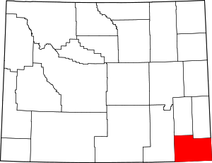 | |
| Towns | ||
| CDPs | ||
| Unincorporated communities | ||