Pine Bluffs, Wyoming
| Pine Bluffs, Wyoming | |
|---|---|
| Town | |
 Location in Laramie County and the state of Wyoming. | |
 Pine Bluffs, Wyoming Location in the United States | |
| Coordinates: 41°10′46″N 104°4′7″W / 41.17944°N 104.06861°WCoordinates: 41°10′46″N 104°4′7″W / 41.17944°N 104.06861°W | |
| Country | United States |
| State | Wyoming |
| County | Laramie |
| Area[1] | |
| • Total | 3.22 sq mi (8.34 km2) |
| • Land | 3.22 sq mi (8.34 km2) |
| • Water | 0 sq mi (0 km2) |
| Elevation | 5,049 ft (1,539 m) |
| Population (2010)[2] | |
| • Total | 1,129 |
| • Estimate (2012[3]) | 1,147 |
| • Density | 350.6/sq mi (135.4/km2) |
| Time zone | Mountain (MST) (UTC-7) |
| • Summer (DST) | MDT (UTC-6) |
| ZIP code | 82082 |
| Area code(s) | 307 |
| FIPS code | 56-61435[4] |
| GNIS feature ID | 1609139[5] |
Pine Bluffs is a town in eastern Laramie County, Wyoming, United States. It is located on the county's border with Nebraska. It is part of the Cheyenne, Wyoming, Metropolitan Statistical Area. The population was 1,129 at the 2010 census.[6] It was first known as Rock Ranch, but the name was changed by railroad officials for the pines on the nearby bluffs.
History
.jpg)
In 1868 Pine Bluffs consisted of a tent, a slab shack with a stone chimney, and a square shed of canvas-covered poles. Cattle herds moved up the Texas Trail which ran through Pine Bluffs and became the largest cattle shipping point on the Union Pacific Railroad around 1884. A few years later, in 1898, C.W. Johnson opened up one of Pine Bluffs' oldest stores. It was a proven success from the beginning, and remained opened until the latter half of the 20th century. By the early 1900s Pine Bluffs was known as the best lighted city of it size in the entire United States. The Pine Bluffs Lighting Company was organized in September 1909. This company used gas produced by a new process, giving the light more brilliance.
Along with a growing town economy, agricultural endeavors were also booming around Pine Bluffs. In 1909 the local farmers got a chance to show off their hard work and dedication to the land. A unique but successful fair called the "Harvest Festival" was put on to showcase the vegetable and dry-farming section variety in the town. The main feature of the fair was the Grain Palace. Built entirely of different grain crops, this magnificent building covered 24 by 36 feet (7.3 by 11.0 m) and 14 feet (4.3 m) to the eaves. The Grain Palace was filled with exhibits of area artwork made from home-grown products.
Before the cowboys and cattle arrived, the area was home to numerous Indian tribes. Artifacts from these early inhabitants are being uncovered at the Archaeological Dig Site during summer months.
In July 2016, Pine Bluffs was battered by a severe hailstorm, causing widespread damage. The Wyoming National Guard was called in to deal with the damage.[7]
Geography
According to the United States Census Bureau, the town has a total area of 3.22 square miles (8.34 km2), all of it land.[1]
Pine Bluffs experiences a semi-arid climate (Köppen climate classification BSk).
| Climate data for Pine Bluffs | |||||||||||||
|---|---|---|---|---|---|---|---|---|---|---|---|---|---|
| Month | Jan | Feb | Mar | Apr | May | Jun | Jul | Aug | Sep | Oct | Nov | Dec | Year |
| Record high °F (°C) | 70 (21) |
75 (24) |
85 (29) |
86 (30) |
97 (36) |
105 (41) |
109 (43) |
104 (40) |
101 (38) |
91 (33) |
78 (26) |
74 (23) |
109 (43) |
| Average high °F (°C) | 39 (4) |
43 (6) |
49 (9) |
58 (14) |
68 (20) |
80 (27) |
87 (31) |
85 (29) |
75 (24) |
63 (17) |
48 (9) |
40 (4) |
61.3 (16.2) |
| Average low °F (°C) | 12 (−11) |
16 (−9) |
23 (−5) |
30 (−1) |
40 (4) |
49 (9) |
54 (12) |
53 (12) |
43 (6) |
32 (0) |
20 (−7) |
13 (−11) |
32.1 (−0.1) |
| Record low °F (°C) | −34 (−37) |
−31 (−35) |
−21 (−29) |
−3 (−19) |
18 (−8) |
26 (−3) |
32 (0) |
34 (1) |
6 (−14) |
−4 (−20) |
−17 (−27) |
−38 (−39) |
−38 (−39) |
| Average precipitation inches (mm) | 0.44 (11.2) |
0.28 (7.1) |
1.12 (28.4) |
1.59 (40.4) |
2.44 (62) |
2.26 (57.4) |
2.51 (63.8) |
2.05 (52.1) |
1.28 (32.5) |
0.67 (17) |
0.55 (14) |
0.40 (10.2) |
15.59 (396) |
| Source: Weather.com[8] | |||||||||||||
Demographics
| Historical population | |||
|---|---|---|---|
| Census | Pop. | %± | |
| 1910 | 246 | — | |
| 1920 | 618 | 151.2% | |
| 1930 | 670 | 8.4% | |
| 1940 | 771 | 15.1% | |
| 1950 | 846 | 9.7% | |
| 1960 | 1,121 | 32.5% | |
| 1970 | 937 | −16.4% | |
| 1980 | 1,077 | 14.9% | |
| 1990 | 1,054 | −2.1% | |
| 2000 | 1,153 | 9.4% | |
| 2010 | 1,129 | −2.1% | |
| Est. 2015 | 1,146 | [9] | 1.5% |
2010 census
As of the census[2] of 2010, there were 1,129 people, 476 households, and 314 families residing in the town. The population density was 350.6 inhabitants per square mile (135.4/km2). There were 532 housing units at an average density of 165.2 per square mile (63.8/km2). The racial makeup of the town was 94.2% White, 0.2% African American, 0.9% Native American, 0.4% Asian, 2.3% from other races, and 2.0% from two or more races. Hispanic or Latino of any race were 11.1% of the population.
There were 476 households of which 31.5% had children under the age of 18 living with them, 52.9% were married couples living together, 8.0% had a female householder with no husband present, 5.0% had a male householder with no wife present, and 34.0% were non-families. 30.0% of all households were made up of individuals and 11.6% had someone living alone who was 65 years of age or older. The average household size was 2.35 and the average family size was 2.92.
The median age in the town was 42.6 years. 25.2% of residents were under the age of 18; 6.2% were between the ages of 18 and 24; 21.7% were from 25 to 44; 28.7% were from 45 to 64; and 18.2% were 65 years of age or older. The gender makeup of the town was 51.0% male and 49.0% female.
2000 census
As of the census[4] of 2000, there were 1,153 people, 482 households, and 332 families residing in the town. The population density was 357.4 people per square mile (137.8/km²). There were 517 housing units at an average density of 160.3 per square mile (61.8/km²). The racial makeup of the town was 95.92% White, 0.17% African American, 0.69% Native American, 0.17% Asian, 1.82% from other races, and 1.21% from two or more races. Hispanic or Latino of any race were 6.85% of the population.
There were 482 households out of which 30.1% had children under the age of 18 living with them, 55.2% were married couples living together, 9.8% had a female householder with no husband present, and 31.1% were non-families. 28.2% of all households were made up of individuals and 14.9% had someone living alone who was 65 years of age or older. The average household size was 2.38 and the average family size was 2.90.
In the town the population was spread out with 27.3% under the age of 18, 5.6% from 18 to 24, 23.2% from 25 to 44, 25.0% from 45 to 64, and 18.9% who were 65 years of age or older. The median age was 41 years. For every 100 females there were 95.1 males. For every 100 females age 18 and over, there were 87.9 males.
The median income for a household in the town was $33,152, and the median income for a family was $40,417. Males had a median income of $30,078 versus $20,500 for females. The per capita income for the town was $15,525. About 7.3% of families and 10.1% of the population were below the poverty line, including 15.2% of those under age 18 and 8.3% of those age 65 or over.
Education
Public education in the town of Pine Bluffs is provided by Laramie County School District #2. Schools serving the town include Pine Bluffs Elementary School (grades K-6) and Pine Bluffs Junior/Senior High School (grades 7-12).
References
- 1 2 "US Gazetteer files 2010". United States Census Bureau. Archived from the original on 24 January 2012. Retrieved 14 December 2012.
- 1 2 "American FactFinder". United States Census Bureau. Retrieved 14 December 2012.
- ↑ "Population Estimates". United States Census Bureau. Archived from the original on 17 June 2013. Retrieved 1 June 2013.
- 1 2 "American FactFinder". United States Census Bureau. Retrieved 2008-01-31.
- ↑ "US Board on Geographic Names". United States Geological Survey. 2007-10-25. Retrieved 2008-01-31.
- ↑ "Profile of General Population and Housing Characteristics: 2010 Demographic Profile Data (DP-1): Pine Bluffs town, Wyoming". U.S. Census Bureau, American Factfinder. Retrieved 2 April 2012.
- ↑ http://www.wyomingnews.com/news/golf-ball-sized-hail-pounds-pine-bluffs/article_1f700bf8-5552-11e6-851d-f7ac7126e75d.html
- ↑ Weather.com—. Retrieved 30 July 2010.
- ↑ "Annual Estimates of the Resident Population for Incorporated Places: April 1, 2010 to July 1, 2015". Retrieved July 2, 2016.
- ↑ "Census of Population and Housing". Census.gov. Archived from the original on 11 May 2015. Retrieved June 4, 2015.
External links
Municipalities and communities of Laramie County, Wyoming, United States | ||
|---|---|---|
| City | 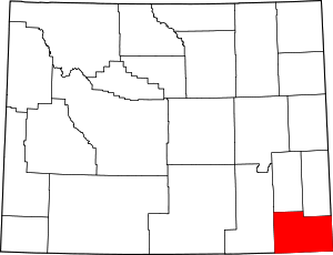 | |
| Towns | ||
| CDPs | ||
| Unincorporated communities | ||