Buariki (Aranuka)
 Map of Aranuka | |||||
 | |||||
| Geography | |||||
|---|---|---|---|---|---|
| Location | Pacific Ocean | ||||
| Coordinates | 0°09′N 173°35′E / 0.150°N 173.583°E | ||||
| Archipelago | Gilbert Islands | ||||
| Area | 13.228 km2 (5.107 sq mi) | ||||
| Highest elevation | 3 m (10 ft) | ||||
| Administration | |||||
| Demographics | |||||
| Population | 1,057 (2010 Census) | ||||
| Pop. density | 79.9 /km2 (206.9 /sq mi) | ||||
| Ethnic groups | I-Kiribati 99.6% | ||||
| Additional information | |||||
| |||||
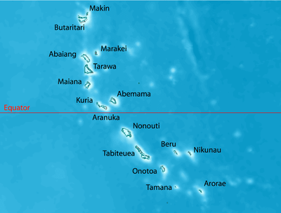
Buariki is the largest island in the Aranuka atoll of the Gilbert Islands in the Republic of Kiribati. Together with Takaeang the two large islands form the triangle shape of the atoll with Buariki forming the base.[1]
Villages
- Baurua
- Buariki
Air transportation
The humble Aranuka Airport is located about one kilometre north of Buariki village.
See also
References
- ↑ "10. Aranuka" (PDF). Office of Te Beretitent - Republic of Kiribati Island Report Series. 2012. Retrieved 28 April 2015.
| Gilbert Islands |  | |
|---|---|---|
| Phoenix Islands | ||
| Line Islands | ||
| West of Gilberts | ||
| Reefs | ||
| ||
This article is issued from Wikipedia - version of the 11/11/2016. The text is available under the Creative Commons Attribution/Share Alike but additional terms may apply for the media files.