Starbuck Island
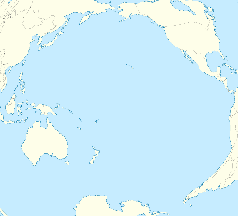

Starbuck Island (or Volunteer Island) is an uninhabited coral atoll in the central Pacific, and is part of the Central Line Islands of Kiribati. Former names include "Barren Island", "Coral Queen Island", "Hero Island", "Low Island", and "Starve Island".
Geography, flora and fauna
Located at 5°38′30″S 155°52′40″W / 5.64167°S 155.87778°WCoordinates: 5°38′30″S 155°52′40″W / 5.64167°S 155.87778°W, and measuring 8.9 kilometres (5.5 miles) east-to-west and 3.5 kilometres (2.2 miles) north-to-south, Starbuck Island has a land area of 1,620 hectares (4,003 acres).[1] It is a low, dry, coral limestone island with a steep beach backed by a 6–8-metre-high (20–26 ft) bank composed of large coral fragments. Several hypersaline lagoons form on the island's eastern side. These occasionally dry up, and are said to be dangerous to approach: one worker during the island's guano-mining days sank up to his neck in salty mud before being rescued.[2]
There is no freshwater on the island, which is one of the drier atolls in the Line Island group. Annual yearly rainfall averages approximately 800 mm (31.5 in).[1]
Little vegetation exists on Starbuck; stunted Sida fallax scrub and low herbs and grasses predominate, with a few Cordia subcordata bushes and bunch grass rounding out the flora. Recent photos showed a few palm trees growing near the center of the island.[3]
The island boasts a large colony of sooty terns, estimated at 1.5 million pairs, together with Polynesian rats, feral cats, green turtles, and around fifteen other species of seabirds.[1] Other accounts estimate the sooty tern population to be as high as three to six million birds.[4]
The island was noted for the unbearable screaming of seabirds, extreme heat and blinding sunlight.
History
Starbuck Island was first sighted in 1823 by Valentine Starbuck, American-born master of the British whaling ship L'Aigle on which young king and queen of Hawaii, travelled to England in 1823–1824,[5] However it had probably been sighted previously that same year by his cousin and fellow-whaler Capt. Obed Starbuck.[6] Starbuck Island was charted in 1825 by Captain The 7th Lord Byron (a cousin of the famous poet). Byron, commanding the British warship HMS Blonde, was returning to London from a special mission to Honolulu to repatriate the remains of the Hawaiian royal couple, King Kamehameha II and Queen Kamāmalu who had died of measles while trying to visit King George IV. Lord Byron discovered and charted Malden Island, which he named after his surveying officer, Mauke, and Starbuck Island.[7]
It was claimed by the United States under the 1856 Guano Act, but controlled by Britain after 1866, when possession was taken by Commodore Swinburn of HMS Mutine. Starbuck Island was mined for phosphate between 1870 and 1893. Because of its low profile (at its highest point, the island rises to about 5 meters) and the dangerous surrounding reefs, a number of ships were wrecked at Starbuck Island in the late 19th century, including the French transport Euryale on March 10, 1870. The captain of this ship, the future contre-admiral Albert Des Portes, who stayed 35 days with his crew on the atoll before being rescued and coming back to France with all the members, finally found the right geographical location of the island. In August 7, 1896 the Norwegian ship "Seladon" was wrecked against the barrier. The crew went into the lifeboats and drifted for 30 days until they landed on the island of Niulakita, Tuvalu. For 10 months they lived together with a few natives until they were picked up by a ship and rescued.[8]
The island formed a part of the British Gilbert and Ellice Islands Colony prior to the independence of Kiribati in 1979. American claims to the atoll were formally vacated in the Treaty of Tarawa, signed that same year.[9]
Starbuck Island has been designated as the Starbuck Island Wildlife Sanctuary.[10] In 2014 the Kiribati government established a 12-nautical-mile fishing exclusion zone around each of the southern Line Islands: Caroline (commonly called Millennium), Flint, Vostok, Malden, and Starbuck).[11]
Photo gallery
 Starbuck as seen from space
 Map of Starbuck Island
 Ruined wall from 19th-century guano settlement on Starbuck Island
 Sooty tern colony on Starbuck Island
 Largely barren interior of Starbuck Island
 Bidens Kiribatiensis on Starbuck Island
See also
References
- 1 2 3 http://www.unep-wcmc.org/sites/wetlands/starbuck.htm. Retrieved on 7 July 2008.
- ↑ http://www.janeresture.com/kiribati_line/starbuck.htm. Retrieved on 7 July 2008.
- ↑ http://www.theoceanadventure.com/NemoIE03/DAY18Nemo.html. Retrieved 10 July 2008.
- ↑ World Wildlife Fund (2001). "Central Polynesian tropical moist forests". WildWorld Ecoregion Profile. National Geographic Society. Archived from the original on 2010-03-08. Retrieved 10 July 2008.
- ↑ Bryan, p. 128
- ↑ Dunmore, pp. 237-8
- ↑ Dunmore, p 46
- ↑ Wincent Rege, Malvin Rege & Eli Rege (2012). The wreck of the Seladon: A true survival on an island story. CreateSpace. ISBN 978-1470002459.
- ↑ "Treaty of friendship between the United States of America and the Republic of Kiribati". Retrieved 2013-06-08.
Advise and consent to ratification by the Senate June 21, 1983;
- ↑ Edward R. Lovell, Taratau Kirata & Tooti Tekinaiti (September 2002). "Status report for Kiribati's coral reefs" (PDF). Centre IRD de Nouméa. Retrieved 15 May 2015.
- ↑ Warne, Kennedy (September 2014). "A World Apart – The Southern Line Islands". National Geographic. Retrieved 15 May 2015.
Sources
- Bloxam, Andrew (1925), Diary of Andrew Bloxam: naturalist of the "Blonde" on her trip from England to the Hawaiian islands, 1824-25 Volume 10 of Bernice P. Bishop Museum special publication
- Bryan, Jr., Edwin H. (1942); American Polynesia and the Hawaiian Chain, Honolulu, Hawaii: Tongg Publishing Company
- Dunmore, John (1992); Who's Who in Pacific Navigation, Australia:Melbourne University Press, ISBN 0-522-84488-X
- Quanchi, Max & Robson, John, (2005); Historical Dictionary of the Discovery and Exploration of the Pacific Islands, USA: Scarecrow Press, ISBN 0-8108-5395-7
External links
- National Geographic - Southern Line Islands Expedition, 2014
- Starbuck Island
- Starbuck Island Interior photo
- Looking For Nemo Expedition
| Gilbert Islands |  | |
|---|---|---|
| Phoenix Islands | ||
| Line Islands | ||
| West of Gilberts | ||
| Reefs | ||
| ||