Arorae
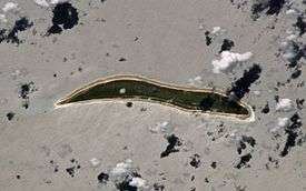
Arorae (previously known as Arorai, Arurai, Hope Island or Hurd) is an atoll in Kiribati located near the equator. Arorae is the southern-most island in the Gilbert Islands group.[1] It houses almost 1300 people on 9.5 square km.
Geography
The atoll's area is 9.5 km2 (3.7 sq mi) The atoll is a low and flat coralline island with an elongated shape. It is 9 km in length and 1 km wide. Because it is a small atoll, there is no lagoon.
The population of Arorae in the 2010 census was 1,279, most of whom are Protestants.[1]
There are only two villages on the island, Tamaroa, the northern village and Roreti (a local transliteration of "Royalist"), the southern village. The government station is located between the two villages at Taribo. There are churches at Tamaroa and Roreti. These churches were built from pure limestone rock hacked from the island base itself in the early 1870s during the initial establishment of Christianity on the island by the London Missionary Society, which later became the Kiribati Protestant Church (KPC).[1]
- Tamaroa (population 426, 2010 census)
- Roreti (population 853, 2010 census)
Culture
Arorae culture has been influenced by Samoa more than most of the other atolls in the Gilbert Islands (Kiribati). This is because Samoan missionaries settled there and converted the island's residents to the Protestant Church. The Samoan presence in Arorae shaped their style of dancing, making Arorae known for the "taubati", a dance using claps, slaps, and stomps as visual percussion to accompany local songs.
Because it is a more remote outer-island within the Gilbert line of the Republic of Kiribati, it is known for maintaining a more traditional culture held together mostly under the authority of "unimwane" (village elders).
Arorae fishermen are skilled at catching large tuna and shark using hand lines. Arorae fisherman usually save the dorsal shark fin to export for shark fin soup; however, the island has a strict law against cutting the dorsal fin of any shark without taking the entire shark ashore for food.[1]
At the northern tip of Arorae is a set of stones (circa 1000 - 1500 AD) that mark out the initial directions for voyages to the other islands - Tamana, Nikunau, Beru and Onotoa. These stones are no longer visible from the sea, but are still called "Te Atibu ni Borau" or "navigational stones". Close to the navigational stones is the "migratory" beach, which disappears and reappears at certain times of the year.[1]
History
Arorae Post Office opened around 1923.[2]
Transportation
By air
Arorae Island Airport, featuring Air Kiribati scheduled service on Thursdays, is located in the north of the island, north of the village of Tamaroa.
References
- 1 2 3 4 5 "18. Arorae" (PDF). Office of Te Beretitent - Republic of Kiribati Island Report Series. 2012. Retrieved 28 April 2015.
- ↑ Premier Postal History. "Post Office List". Premier Postal Auctions. Retrieved 5 July 2013.
External links
- http://www.panoramio.com/photo/32000187
- Exhibit: The Alfred Agate Collection: The United States Exploring Expedition, 1838-1842 from the Navy Art Gallery
| Gilbert Islands |  | |
|---|---|---|
| Phoenix Islands | ||
| Line Islands | ||
| West of Gilberts | ||
| Reefs | ||
| ||
Coordinates: 2°38′37″S 176°49′54″E / 2.64361°S 176.83167°E