Brown City, Michigan
| Brown City, Michigan | |
|---|---|
| City | |
 Location of Brown City, Michigan | |
| Coordinates: 43°12′43″N 82°59′19″W / 43.21194°N 82.98861°W | |
| Country | United States |
| State | Michigan |
| Counties | Lapeer, Sanilac |
| Area[1] | |
| • Total | 1.09 sq mi (2.82 km2) |
| • Land | 1.09 sq mi (2.82 km2) |
| • Water | 0 sq mi (0 km2) |
| Elevation | 823 ft (251 m) |
| Population (2010)[2] | |
| • Total | 1,325 |
| • Estimate (2012[3]) | 1,300 |
| • Density | 1,215.6/sq mi (469.3/km2) |
| Time zone | Eastern (EST) (UTC-5) |
| • Summer (DST) | EDT (UTC-4) |
| ZIP code | 48416 |
| Area code(s) | 810 |
| FIPS code | 26-11180[4] |
| GNIS feature ID | 0622071[5] |
| Website | Brown City Official Website |
Brown City is a city in Lapeer and Sanilac counties in the U.S. state of Michigan. The population was 1,325 at the 2010 census. The city is located almost exclusively in Sanilac County, with only a small portion of the city extending into Lapeer County.
History
Brown City was established in 1879. It was incorporated as a village in 1887 and as a city in 1907.[6]
Geography
According to the United States Census Bureau, the city has a total area of 1.09 square miles (2.82 km2), all land.[1]
Demographics
| Historical population | |||
|---|---|---|---|
| Census | Pop. | %± | |
| 1890 | 437 | — | |
| 1900 | 603 | 38.0% | |
| 1910 | 690 | 14.4% | |
| 1920 | 828 | 20.0% | |
| 1930 | 785 | −5.2% | |
| 1940 | 838 | 6.8% | |
| 1950 | 878 | 4.8% | |
| 1960 | 993 | 13.1% | |
| 1970 | 1,142 | 15.0% | |
| 1980 | 1,163 | 1.8% | |
| 1990 | 1,244 | 7.0% | |
| 2000 | 1,334 | 7.2% | |
| 2010 | 1,325 | −0.7% | |
| Est. 2015 | 1,274 | [7] | −3.8% |
2010 census
As of the census[2] of 2010, there were 1,325 people, 524 households, and 350 families residing in the city. The population density was 1,215.6 inhabitants per square mile (469.3/km2). There were 587 housing units at an average density of 538.5 per square mile (207.9/km2). The racial makeup of the city was 97.2% White, 0.1% African American, 0.2% Native American, 0.1% Asian, 0.5% from other races, and 2.0% from two or more races. Hispanic or Latino of any race were 2.3% of the population.
There were 524 households of which 35.5% had children under the age of 18 living with them, 46.0% were married couples living together, 16.8% had a female householder with no husband present, 4.0% had a male householder with no wife present, and 33.2% were non-families. 27.5% of all households were made up of individuals and 11.8% had someone living alone who was 65 years of age or older. The average household size was 2.49 and the average family size was 3.07.
The median age in the city was 37.3 years. 27.8% of residents were under the age of 18; 8.4% were between the ages of 18 and 24; 24.6% were from 25 to 44; 24.5% were from 45 to 64; and 14.9% were 65 years of age or older. The gender makeup of the city was 46.3% male and 53.7% female.
2000 census
As of the census[4] of 2000, there were 1,334 people, 520 households, and 361 families residing in the city. The population density was 1,247.3 per square mile (481.4/km²). There were 562 housing units at an average density of 525.5 per square mile (202.8/km²). The racial makeup of the city was 97.90% White, 0.07% African American, 0.22% Native American, 0.60% from other races, and 1.20% from two or more races. Hispanic or Latino of any race were 3.30% of the population.
There were 520 households out of which 34.8% had children under the age of 18 living with them, 54.2% were married couples living together, 12.1% had a female householder with no husband present, and 30.4% were non-families. 26.7% of all households were made up of individuals and 13.5% had someone living alone who was 65 years of age or older. The average household size was 2.55 and the average family size was 3.08.
In the city the population was spread out with 28.6% under the age of 18, 9.4% from 18 to 24, 29.2% from 25 to 44, 19.1% from 45 to 64, and 13.6% who were 65 years of age or older. The median age was 33 years. For every 100 females there were 89.8 males. For every 100 females age 18 and over, there were 89.6 males.
The median income for a household in the city was $33,906, and the median income for a family was $40,000. Males had a median income of $36,750 versus $20,938 for females. The per capita income for the city was $15,929. About 9.0% of families and 11.7% of the population were below the poverty line, including 11.9% of those under age 18 and 11.9% of those age 65 or over.
References
Notes
- 1 2 "US Gazetteer files 2010". United States Census Bureau. Archived from the original on 2012-07-14. Retrieved 2012-11-25.
- 1 2 "American FactFinder". United States Census Bureau. Retrieved 2012-11-25.
- ↑ "Population Estimates". United States Census Bureau. Archived from the original on 2013-06-17. Retrieved 2013-06-03.
- 1 2 "American FactFinder". United States Census Bureau. Archived from the original on 2013-09-11. Retrieved 2008-01-31.
- ↑ U.S. Geological Survey Geographic Names Information System: Brown City, Michigan
- ↑ Romig 1986, p. 82.
- ↑ "Annual Estimates of the Resident Population for Incorporated Places: April 1, 2010 to July 1, 2015". Retrieved July 2, 2016.
- ↑ "Census of Population and Housing". Census.gov. Archived from the original on May 11, 2015. Retrieved June 4, 2015.
Sources
- Romig, Walter (October 1, 1986) [1973]. Michigan Place Names: The History of the Founding and the Naming of More Than Five Thousand Past and Present Michigan Communities. Great Lakes Books Series (Paperback). Detroit, Michigan: Wayne State University Press. ISBN 0-8143-1838-X. ISBN 978-0814318386.
External links
Municipalities and communities of Lapeer County, Michigan, United States | ||
|---|---|---|
| Cities | 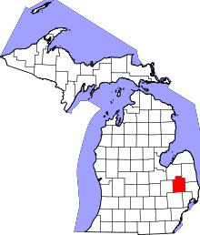 | |
| Villages | ||
| Townships | ||
| CDPs | ||
| Other unincorporated communities | ||
| Footnotes | ‡This populated place also has portions in an adjacent county or counties | |
Municipalities and communities of Sanilac County, Michigan, United States | ||
|---|---|---|
| Cities |  | |
| Villages | ||
| Townships | ||
| CDP | ||
| Other unincorporated communities | ||
| Footnotes | ‡This populated place also has portions in an adjacent county or counties | |
Coordinates: 43°12′44″N 82°59′23″W / 43.21222°N 82.98972°W