Brooklyn Heights
| Brooklyn Heights | |
|---|---|
| Neighborhood of Brooklyn | |
|
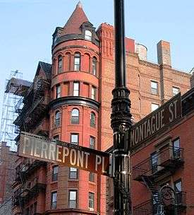
62 Montague Street between Pierrepont Place and Hicks Street in Brooklyn Heights (2006) | |
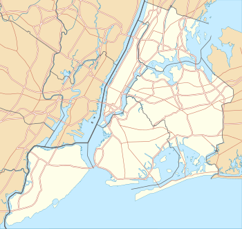 Brooklyn Heights  Brooklyn Heights  Brooklyn Heights Location in New York City | |
| Coordinates: 40°41′44″N 73°59′42″W / 40.69556°N 73.99500°WCoordinates: 40°41′44″N 73°59′42″W / 40.69556°N 73.99500°W | |
| Country |
|
| State |
|
| City | New York City |
| Borough | Brooklyn |
| Languages[1] | |
| Area | |
| • Total | 0.320 sq mi (0.83 km2) |
| Population (2010) | |
| • Total | 20,256 |
| • Density | 63,000/sq mi (24,000/km2) |
| Demographics 2010[2] | |
| • White | 77% |
| • Black | 7% |
| • Hispanic (of any race) | 8% |
| • Asian | 5% |
| • Other | 3% |
| ZIP Codes | 11201 |
| Median household income | $119,999[3] |
Brooklyn Heights is an affluent residential neighborhood within the New York City borough of Brooklyn. Originally referred to as Brooklyn Village, it has been a prominent area of Brooklyn since 1834. The neighborhood is noted for its low-rise architecture and its many brownstone rowhouses, most of them built prior to the Civil War. It also has an abundance of notable churches and other religious institutions. Brooklyn's first art gallery, the Brooklyn Arts Gallery, was opened in Brooklyn Heights in 1958.[4] In 1965, a large part of Brooklyn Heights was protected from unchecked development by the creation of the Brooklyn Heights Historic District, the first such district in New York City. The district was added to the National Register of Historic Places in 1966.
Directly across the East River from Manhattan and connected to it by subways and regular ferry service, Brooklyn Heights is also easily accessible from Downtown Brooklyn. The neighborhood stretches from Old Fulton Street near the Brooklyn Bridge south to Atlantic Avenue and from the Brooklyn-Queens Expressway to Court Street and Cadman Plaza West.[5] Adjacent neighborhoods are Dumbo, Downtown Brooklyn, Cobble Hill, and Boerum Hill. Columbia Heights, an upscale six-block-long street next to the Brooklyn Heights Promenade,[6] is sometimes considered to be its own neighborhood.
As of 2000, Brooklyn Heights had a population of 22,594 people. The neighborhood is part of Brooklyn Community Board 2,[7] and is served by the 84th Precinct of the New York City Police Department at 301 Gold Street in nearby Downtown Brooklyn.[8] Fire services from the Fire Department of New York City come from Engine Company 205 and Ladder Company 118 at 74 Middagh Street, Engine Company 207 and Ladder Company 110 at 172 Tillary Street, and Engine Company 224 at 274 Hicks Street.[9]
History
Early settlement
Brooklyn Heights occupies a palisade that rises sharply from the river's edge and gradually recedes on the landward side. Before the Dutch settled on Long Island in the middle of the seventeenth century, this promontory was called Ihpetonga ("the high sandy bank") by the native Lenape American Indians.[10]
Ferries across the East River were running as early as 1642, serving the farms in the area. The most significant of the ferries went between the current Fulton Street and Peck Slip in Manhattan, and was run by Cornelius Dirksen. The ferry service helped the lowland area to thrive, with both farms and some factories along the water, but the higher ground was sparsely used.[5]
The area was heavily fortified prior to the Battle of Long Island in the American Revolutionary War, After British troops landed on Long Island and advanced towards Continental Army lines, General George Washington withdrew his troops here after heavy losses, but was able to make a skillful retreat across the East River to Manhattan without the loss of any troops or his remaining supplies.

After the War, the 160-acre tract of land belonging to John Rapeljie, who was a Loyalist, was confiscated and sold to the Sands brothers, who tried to develop the part of the land on the palisade as a community they called "Olympia", but failed to make it come about, partly because of the difficulty of building there. They later sold part of their land to John Jackson, who created the Vinegar Hill community, much of which later became the Brooklyn Navy Yard.[11]
Development
Brooklyn Heights began to develop once Robert Fulton's New York and Brooklyn Steam Ferry Boat Company began regularly scheduled steam ferry service in 1814, with the financial backing of Hezekiah Beers Pierrepont, one of the area's major landowners.[12] Pierrepont had accumulated 60 acres of land, including 800 feet which directly overlooked the harbor, all of which he planned to sub-divide. Since his intention was to sell to merchants and bankers who lived in Manhattan, he needed easy access between Brooklyn Heights and New York City, which Fulton's company provided.[13]
Thanks to the influence of Pierrepont and other landowners, Brooklyn received a charter from the state as a village in 1816, which led to streets being laid out in a regular grid pattern, sidewalks being laid, water pumps being installed and the institution of a watch.[13] After 1823, farms begin to be sub-divided into 25-by-100-foot (7.6 by 30.5 m) lots, which were advertised as suitable for a "country retreat" for Manhattanites, leading to a building boom that resulted in Brooklyn Heights becoming the "first commuter suburb,"[5][14] since it was easier and faster to get to Manhattan by ferry than it was to commute from upper Manhattan by ground transportation.[12] A resident of the Heights could leave the office at three o'clock, have dinner at home at four o'clock, and still have time for a "leisurely drive to the outskirts of town", a "middle class paradise."[15] The community's development was helped by the yellow fever epidemic of 1822, when many of the rich from the city abandoned it for an area that was advertised as "elevated and perfectly healthy at all seasons ... a select neighborhood and circle of society."[13]
Where there had been only seven houses in the Heights in 1807,[12] by 1860 there were over six hundred of them,[16] and by 1890 the area was almost completely developed.[12] The buildings were designed in a wide variety of styles; development started in the northern part, and moved southward, so the architecture general changes in that direction as the preferred style of the time changed over the decades.[9] Throughout the 19th century, Brooklyn Heights remained an elegant neighborhood,[5] and became Brooklyn's cultural and financial center.[9] Its development gave rise to offshoots such as Cobble Hill and, later, Carroll Gardens.[17]
Prior to the Civil War, Brooklyn Heights was a locus of the Abolitionist movement, due to the speeches and activities of Henry Ward Beecher, the pastor of Plymouth Church, now the Plymouth Church of the Pilgrims. Beecher was a nationally-known figure famous on the lecture circuit for his novel oratorical style, in which he employed humor, dialect, and slang. Under Beecher, who preached at the church for over 40 years, Plymouth Church was known as the "Grand Central Station of the Underground Railroad" for the number of slaves it was said had passed through on their way to freedom in Canada. To dramatize the plight of those held in captivity, Beecher once brought a female slave to the church and held an auction, with the highest bidder purchasing not the slave, but her freedom. Beecher also raised money to buy other slaves out of captivity, and shipped rifles to abolitionists in Kansas and Nebraska in crates labelled "Bibles", which gave the rifles the nickname "Beecher's Bibles".[9]

20th century
The completion of the Brooklyn Bridge in 1883, the Brooklyn end of which was near Brooklyn Heights' eastern boundary, began the process of making the neighborhood more accessible from places such as Manhattan. The Interborough Rapid Transit Company (IRT)'s Lexington Avenue subway line, which reached Brooklyn Heights in 1908, was an even more powerful catalyst in the neighborhood's development. The resulting ease of transportation into the neighborhood and the perceived loss of the specialness and "quality" began to drive out the merchants and patricians who lived there; in time their mansions were divided to become apartment houses and boarding houses. Artists began to move in to the neighborhood, as well as writers, and a number of large hotels – the St. George (1885), the Margaret (1889), the Bossert (1909), Leverich Towers (1928), and the Pierrepont (1928), among others[9][12] – were constructed. By the beginning of the Depression, most of the middle class had left the area. Boarding houses had become rooming houses, and the neighborhood began to have the appearance of a slum.[5][9]
During the 1940s and '50s, the building of the Brooklyn-Queens Expressway (BQE) badly affected the neighborhood, as it took away the neighborhood's northwest corner, destroying whole rows of brownstones.[9] At about the same time, plans began to be developed by New York's "master builder", Robert Moses, wielding the Housing Act of 1949,[16] to replace brownstone row houses which were the typical building form in the neighborhood with large luxury apartment buildings.[5] A prominent example of the intended outcome is the Cadman Plaza development of housing cooperatives in the northern part of the neighborhood, located on the site where the Brooklyn Bridge trolley terminal once stood.[9] In 1959, the North Heights Community Group was formed to oppose destroying cheap low-rise housing in order to build the high-rise Cadman Plaza towers. Architect Percival Goodman presented an alternate plan to maintain all sound structures, which garnered 25,000 supporters. In early 1961, a compromise proposal came from City Hall calling for two 22 story towers with over 1,200 luxury and middle income units. The Brooklyn Heights Association fully supported the compromise plan despite strong opposition from the preservation community, including the North Heights Community Group. As a result, 1,200 residents were removed from their houses and apartments in late 1961/early 1962 as construction began on the modified plan.[18][19]
One positive development came about when community groups – prominently the Brooklyn Heights Association, founded in 1910[9] – joined with Moses in the creation of the Brooklyn Heights Promenade, also called the Esplanade, which was cantilevered over the BQE. It became a favorite spot among locals, offering magnificent vistas of the Statue of Liberty, the Manhattan skyline across the East River, the Brooklyn Bridge, the Manhattan Bridge, and spectacular fireworks displays over the East River. Moses originally proposed to build the BQE through the heart of Brooklyn Heights. Opposition to this plan led to the re-routing of the expressway to the side of the bluff, allowing creation of the Promenade.[20]
By the mid-1950s, a new generation of property owners had begun moving into the Heights, pioneering the "Brownstone Revival" by buying and renovating pre-Civil War period houses, which became part of the preservationist movement which culminated in the passage in 1965 of the Landmarks Preservation Law.[21] In 1965, community groups which later became the Brooklyn Heights Association, succeeded in having the neighborhood designated the Brooklyn Heights Historic District by the New York City Landmarks Preservation Commission, the first such district in the city. This was followed in the following decades by the further gentrification of the neighborhood into a firmly middle-class area, which became "one of New York City's most pleasant and attractive neighborhoods."[5]
Architecture and places of interest
Brooklyn Heights was the first neighborhood protected by the 1965 Landmarks Preservation Law of New York City. The neighborhood is largely composed of blocks of picturesque rowhouses and a few mansions. A great range of architectural styles is represented, including Greek Revival, Italianate, Second Empire, Victorian Gothic, Romanesque, Neo-Grec, and Classical Revival, as well as a few 2/1/2-story late Federal houses from the early 19th century in the northern part of the neighborhood.[22] Some houses were constructed of brick, but the dominant building material was brownstone or "Jersey freestone", a reddish-brown stone from Passaic County, New Jersey.[16]
A typical brownstone rowhouse was three or four stories tall, with the main floor above the street level and reached by stairs, referred to as a "stoop", a word derived from Dutch. The basement is typically a half-flight down from the street, and was used as the work area for servants, including the kitchen. The first floor would be the location of the public rooms, bedrooms were on the second floor, and servants quarters were on the top floor. The rear of the lot would feature a private garden.[16] Aside from rowhouses, a number of houses, particularly along Pierrepont Street and Pierrepont Place, are authentic mansions.
The concentration of over 600 pre-Civil War houses, one of the largest ensembles of such housing in the nation, and the human scale of the three, four- and five-story buildings creates a neighborly atmosphere.
Brooklyn Heights has very few high-rise buildings. Among these buildings are 75 Livingston Street, Hotel St. George, and the Concord Village co-op development on Adams Street. Additionally, Jehovah's Witnesses had their world headquarters in the northern part of Brooklyn Heights at 25 Columbia Heights. The organization restored a number of historic buildings to house their staff, including the former Hotel Bossert, once the seasonal home of many Dodgers players, on Montague Street. In 2010, the organization announced plans to begin selling off their numerous properties in the Heights and nearby downtown Brooklyn since they plan to relocate themselves in upstate New York.[23]
The executive offices of the Brooklyn Dodgers were, for many years, located in the Heights, near the intersection of Montague and Court Streets. A plaque on the office building that replaced the Dodgers' old headquarters at 215 Montague Street identifies it as the site where Jackie Robinson signed his major league contract.
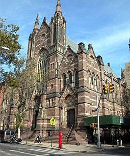
Plymouth Church of the Pilgrims and Our Lady of Lebanon Maronite Catholic Cathedral are located in Brooklyn Heights, as are the First Unitarian Congregational Society, the Long Island Historical Society, Packer Collegiate Institute, and St. Ann's and the Holy Trinity Church, among other historically notable buildings.[22]
-

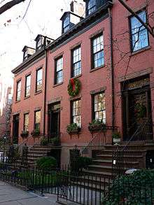
Middagh Street, one of the oldest streets in Brooklyn Heights, contains most of the remaining wood houses; this is #24, the best preserved of the group (all c.1817)[1]
-
155–159 Willow Street, early 19th-century Federal houses (c.1826)[1]
-

Rowhouses on Remsen Street
(c.1860)[1] -

The Herman Behr Mansion
(Frank Freeman, 1889)[1] -
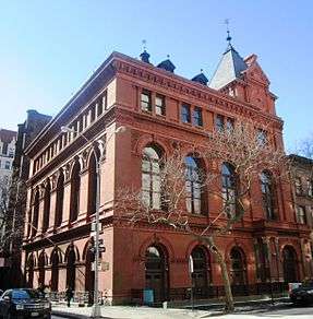
Packer Collegiate Institute
(Minard Lefever, 1853-56; Napoleon LeBrun & Son, 1884, 1886)[1] -
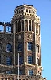
A detail from the Leverich Towers Hotel (Starrett & van Vleck, 1928)[1]
- ^ a b c d e f Cite error: The named reference
aiawas invoked but never defined (see the help page).
-
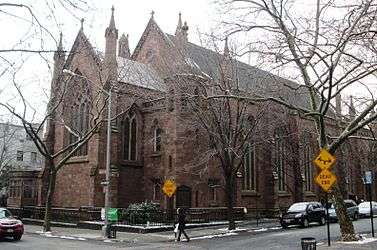
Grace Episcopal Church
(Richard Upjohn, 1847-49)[1] -

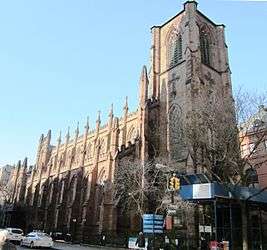
Plymouth Church, now Plymouth Church of the Pilgrims
(Joseph C. Wells, 1849-50)[1] -
St. Ann's and the Holy Trinity Church, formerly Holy Trinity Church
(Minard Lefever, 1844-47)[1] -

Appellate Division Courthouse
(Slee & Bryson, 1938)[1]
Demographics
The 2000 United States Census[24] reported that Brooklyn Heights had a population of 22,594. The racial makeup of Brooklyn Heights was 17,397 (77%) White, 1,581 (7%) African American, 1,129 (5%) Asian, 225 (1%) from other races, and 451 (2%) from two or more races. Hispanic or Latino of any race were 1,807 persons (8%).
The Census reported that of the 22,593 housing units, 12,426 (57%) are renter-occupied, 9,037 (40%) owner-occupied and 677 (3%) vacant.
The population included 2,485 people (11%) under the age of 18, 17,397 people (77%) aged 18 to 64, and 2,711 people (12%) who were 65 years of age or older.
Education
St. Ann's School, a K–12 school, is located in the neighborhood, with the main campus at 129 Pierrepont Street. Packer Collegiate Institute, a K-12 school, has also been located in the neighborhood, at 170 Joralemon Street, since its 1845 founding.
St. Francis College is located on Remsen Street and occupies half a city block. It was founded as St. Francis Academy in 1859 by the Franciscan Brothers and was originally located on Baltic Street. St. Francis College was the first private school in the Roman Catholic Diocese of Brooklyn. As of 2010, 2,000 full-time students and more than 400 part-time students from 80 countries attend the College. St. Francis College has been ranked by the New York Times as one of the more diverse colleges in the United States.[25] The college has also been ranked by both Forbes magazine and U.S. News & World Report as one of the top baccalaureate colleges in the north.[26][27]
Brooklyn Heights is also the location of Brooklyn Law School, founded in 1901, which, as of 2012, had 1,400 students.
Transportation
Brooklyn Heights is serviced by numerous subway services, specifically the A C F N R trains at Jay Street – MetroTech, the 2 3 trains at Clark Street, and the 2 3 4 5 N R trains at Court Street – Borough Hall.[28]
Many MTA Regional Bus Operations bus routes are located nearby in Downtown Brooklyn, with the exception of the B25 in Dumbo/Fulton Ferry and B61, B63 in Cobble Hill. However, no bus routes actually stop in Brooklyn Heights.[29]
Brooklyn Heights is expected to be served by the Citywide Ferry Service[30] starting in 2017.[31][32]
Street names
Many of the streets in Brooklyn Heights are named after people who figured prominently in the neighborhood's history.[33]

.jpg)
- Adams Street – John Adams, second President of the United States; originally named "Congress Street"
- Aitken Place – Monsignor Ambrose Aitken of St. Charles Borromeo Roman Catholic Church
- Cadman Plaza – Dr. Samuel Parkes Cadman, pastor of the Central Congregational Church
- Clark Street – William Clark, ship's captain
- Clinton Street – DeWitt Clinton, mayor of New York City, governor of New York state, three time Presidential candidate
- College Place – named after the Brooklyn Collegiate Institute for Young Ladies (1829-1842); the building became the Mansion House Hotel in 1875
- Court Street – renamed from "George Street" in 1835, even thought there were no courts nearby
- Doughty Street – Charles Doughty, 18th century lawyer, helped create the Village of Brooklyn
- Elizabeth Place – Elizabeth Cornell, built the first Pierrepont mansion
- Fulton Street, Old Fulton Street – Robert Fulton, introduced steam ferry service between Brooklyn Heights and Manhattan; Old Fulton Street was originally to have been named "Kings Highway", and Fulton Street was "Main Street"
- Furman Street – William Furman, state legislator
- Garden Place – originally part of Philip Livingston's garden
- Grace Court, Grace Court Alley – named after Grace Church
- Henry Street – Dr. Thomas Henry, president of the Kings County Medical Society
- Hicks Street – John and Jacob Hicks, 17th century ferry operators
- Hunts Lane – John Hunt, early purchaser of land from Hezekiah Pierrepont
- Joralemon Street – Teunis Joralemon, saddle maker
- Livingston Street – Philip Livingston, the only signer of the Declaration of Independence who was from Brooklyn
- Middagh Street – the Middaghs, a pre-Revolutionary War family
- Monroe Place – James Monroe, fifth President of the United States; the widest street in Brooklyn Heights
- Montague Street – Lady Mary Wortley Montagu, English feminist and activist for smallpox inoculation, a member of the Pierrepont family; originally named "Constable Street" after Anna Marie Constable Pierrepoint
- Pierrepont Street, Pierrepont Place – Hezekiah Pierrepoint, the "founder" of Brooklyn Heights
- Remsen Street – Henry Remsen, son of Ram Jensen Vanderbeeck, a 17th-century blacksmith
- Schermerhorn Street – Peter and Andrew Schermerhorn, merchants and landowners
- Sidney Place – Sir Philip Sidney; originally "Monroe Place" until 1853
- Tillary Street – Dr. James Tillary, who worked on finding a cure for yellow fever
Concerning the "fruit streets" in Brooklyn Heights – Cranberry, Orange and Pineapple Streets – the WPA Guide to New York City reports that before the Civil War, these streets, along with Poplar and Willow Streets, were named after prominent families, but that a member of the Middagh family expressed her dislike of these families by replacing the street signs with botanical names. The city would restore the proper names, and Middagh would put back her own signs. Several iterations of this game ended when Middagh's new names were given official status by a resolution of the alderman.[10] In Historically Speaking, Brooklyn borough historian John B. Manbeck says only that these street names "have questionable origins," as does Love Lane, which reputably gets its name from the meetings that took place there between a pretty girl who lived nearby and her suitors.[33]
Notable residents
There have been many noted residents of Brooklyn Heights. The dates listed are their respective birth and death dates. Famous residents include:
|
|
|
In popular culture
- The 1960s TV show The Patty Duke Show was set at 8 Remsen Street, Brooklyn Heights, and the neighborhood received a name check in the theme song, in which "Patty's only seen the sights a girl can see from Brooklyn Heights."[9][41] The area was also the main setting of The Cosby Show (1984–1992) where the Huxtable family resided in a two-story brownstone at 10 Stigwood Avenue, a fictional address in Brooklyn Heights.
- The 1975 movie Three Days of the Condor, directed by Sydney Pollack and starring Robert Redford and Faye Dunaway, had the fictional residence of Dunaway's character located on Cranberry Street in Brooklyn Heights.
- The 1977 horror film The Sentinel featured exterior shots along the Promenade, most notably of the southernmost building at 13 Remsen Street. The 1987 romantic film Moonstruck that starred Nicolas Cage opposite Cher was also set in the neighborhood. The neighborhood is a popular destination for many TV and film producers, and has been used both for interior and exterior shoots in projects that included Boardwalk Empire, St. James Place, White Collar, and Hostages.[42]
See also
References
Notes
- ↑ "Census data
- ↑ "Brooklyn Heights Demographics Data". 2012.
- ↑ "Brooklyn Heights Income in 2011". Retrieved 2011. Check date values in:
|access-date=(help) - ↑ Walton, Richard J. (January 22, 1958). "One Painting Leads to Birth of Gallery". Brooklyn New York World Telegram. Second Section, In the Heights.
- 1 2 3 4 5 6 7 Fletcher, Ellen. "Brooklyn Heights" in Jackson, Kenneth T., ed. (2010), The Encyclopedia of New York City (2nd ed.), New Haven: Yale University Press, ISBN 978-0-300-11465-2, pp.177-178
- ↑ Weichselbaum, Simone. "It’s Brooklyn’s $10 million street: Brooklyn Heights strip boasts homes with eight-figure prices", New York Daily News (February 7, 2012)
- ↑ Community Boards, New York City. Accessed May 23, 2008.
- ↑ 84th Precinct, NYPD
- 1 2 3 4 5 6 7 8 9 10 11 12 13 Jackson, Kenneth T.; Manbeck, John B., eds. (2004), The Neighborhoods of Brooklyn (2nd ed.), New Haven, Connecticut: Citizens for NYC and Yale University Press, ISBN 0-300-10310-7, pp.34-39
- 1 2 3 4 Federal Writers' Project (1939), New York City Guide, New York: Random House, ISBN 0-403-02921-X (Reprinted by Scholarly Press, 1976; often referred to as WPA Guide to New York City), pp. 442-47
- ↑ Manbeck (2008), pp.99-102
- 1 2 3 4 5 6 White, Norval; Willensky, Elliot; Leadon, Fran (2010), AIA Guide to New York City (5th ed.), New York: Oxford University Press, ISBN 9780195383867, pp.591-610
- 1 2 3 Burroughs & Wallace (1999), pp.450-51
- ↑ Rizzo, Joanna. "Pierrepont: Seeing great potential across the river in Brooklyn" The Real Deal (July 30, 2008)
- ↑ Burroughs & Wallace (1999), p.972
- 1 2 3 4 5 6 7 8 9 10 Manbeck (2008), pp.95-99
- ↑ Burroughs & Wallace (1999), p.933
- ↑ Salzman, Lorna. "Brooklyn Heights Blows It," Brooklyn Rail (July-August 2015), pp.28-29
- ↑ Osman, Suleiman. (2011) The Invention of Brownstone Brooklyn: Gentrification and the Search for Authenticity in Postwar New York New York: Oxford University Press. p.150 ISBN 0195387317
- ↑ Krogius, Henrik. The Brooklyn Heights Promenade Charleston, South Carolina: The History Press, 2011. ISBN 1609495292
- ↑ See Schneider, Martin L. Battling for Brooklyn Heights: The Fight for New York's First Historic District Brooklyn, New York: Brooklyn Heights Press, 2010; and Schneider, Martin L. and Junkersfeld, Karl. "Brooklyn Is My Neighborhood: The Story of New York’s First Historic District" (video) Brooklyn, New York: Brooklyn Heights Press, 2010
- 1 2 New York City Landmarks Preservation Commission; Dolkart, Andrew S. (text); Postal, Matthew A. (text) (2009), Postal, Matthew A., ed., Guide to New York City Landmarks (4th ed.), New York: John Wiley & Sons, ISBN 978-0-470-28963-1, pp.230-235
- ↑ Associated Press (December 14, 2015). "Jehovah's Witnesses could get $1 billion for NYC properties". New York Daily News. Retrieved 2016-01-10.
- ↑ "2010 Census P.L. 94-171 Summary File Data". United States Census Bureau.
- ↑ "Colleges of Many Colors". The New York Times. 2006-11-05. Retrieved 2007-08-15.
- ↑ "America's Best Colleges List". Forbes.com. 2009-08-05. Retrieved 2010-07-08.
- ↑ "Baccalaureate Colleges (North) Rankings". U.S. News & World Report. 2009. Retrieved 2010-07-08.
- ↑ "Subway Map" (PDF). Metropolitan Transportation Authority. November 2016. Retrieved 2016-11-07.
- ↑ Brooklyn Bus Map, mta.info
- ↑ DNAinfoNewYork. "Proposed Routes for NYC's Expanded Ferry Service". Scribd. Retrieved September 22, 2016.
- ↑ "Citywide Ferry Service to Launch in June 2017, Official Says". DNAinfo New York. 2016-03-03. Retrieved 2016-09-22.
- ↑ "New York City's Ferry Service Set to Launch in 2017". NBC New York. Retrieved 9 May 2016.
- 1 2 3 Manbeck (2008), pp. 103-07
- 1 2 3 4 5 Oehler, Kara (June 14, 2005). "Close-Up on Brooklyn Heights". The Village Voice. Retrieved May 23, 2008.
- ↑ "The Truth About Vincent Kartheiser". BlackBook. June 20, 2013.
- 1 2 Manbeck (2008), p.107
- ↑ Lawson, Carol (January 30, 1981). "Leach to direct musical on orphans going west by rail". The New York Times. Section C, Page 2. Retrieved August 27, 2010.
- ↑ Tippins, Sherill (February 6, 2005). "Genius and High Jinks at 7 Middagh Street". The New York Times. Retrieved June 21, 2008.
- ↑ Sengupta, Somini (April 14, 1996). "Brooklyn's Girl Next Door?". The New York Times. Retrieved November 29, 2007.
Whether she ever made a pilgrimage to Ebbets Field or sipped an egg cream beside an open fire hydrant isn't clear, but the mere fact that she was born in Brooklyn Heights is enough for the organizers of Welcome Back to Brooklyn Day on June 9. On that day, Brooklyn Borough President Howard Golden will crown Ms. Moore Homecoming Queen in a rose garden ceremony at the Brooklyn Botanic Garden.
- ↑ "Brooklyn Cultural Institutions Celebrate Walt Whitman, Brooklyn's Poet Laureate, on the 150th Anniversary of Leaves of Grass" (Press release). Brooklyn Public Library. March 24, 2005. Retrieved May 23, 2008.
- ↑ "The Patty Duke Show" TV.com
- ↑ Fink, Homer. "Give the Gift of Movies Filmed in Brooklyn Heights" Brooklyn Heights {November 23, 2014)
Bibliography
- Burrows, Edwin G. & Wallace, Mike (1999), Gotham: A History of New York City to 1898, New York: Oxford University Press, ISBN 0-195-11634-8
- Manbeck, John B. (2008), Brooklyn: Historically Speaking, Charleston, South Carolina: The History Press, ISBN 978-1-59629-500-1
Further reading
- Applegate, Debby. The Most Famous Man in America: The Biography of Henry Ward Beecher. Doubleday, 2006.
- Capote, Truman. A House On the Heights, with a new introduction by George Plimpton. Little Bookroom, 2002.
- Lancaster, Clay. Old Brooklyn Heights: New York's First Suburb. Dover Books, 1979.
- Tippins, Sherill. February House: The Story of W.H. Auden, Carson McCullers, Jane and Paul Bowles, Benjamin Britten, and Gypsy Rose Lee, Under One Roof in Wartime America. Houghton Mifflin, 2005.
External links
| Wikimedia Commons has media related to Brooklyn Heights. |
- "Living in Brooklyn Heights" slideshow from the New York Times
|  | |