Bromela, California
| Bromela, California | |
|---|---|
| Unincorporated community | |
 Bromela, California | |
| Coordinates: 35°01′04″N 120°35′02″W / 35.01778°N 120.58389°WCoordinates: 35°01′04″N 120°35′02″W / 35.01778°N 120.58389°W | |
| Country | United States |
| State | California |
| County | San Luis Obispo |
| Elevation | 52 ft (16 m) |
| Time zone | Pacific (PST) (UTC-8) |
| • Summer (DST) | PDT (UTC-7) |
| Area code(s) | 805 |
| GNIS feature ID | 1660382[1] |
Bromela is an unincorporated community in San Luis Obispo County, California, United States. Bromela is located along the Old Southern Pacific Railroad(Now Union Pacific) south of Arroyo Grande.[2]
References
- ↑ "US Board on Geographic Names". United States Geological Survey. 2007-10-25. Retrieved 2008-01-31.
- ↑ Durham, David L. (1998). California's Geographic Names: A Gazetteer of Historic and Modern Names of the State. Quill Driver Books. p. 861. ISBN 1-884995-14-4.
Municipalities and communities of San Luis Obispo County, California, United States | ||
|---|---|---|
| Cities | 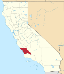 | |
| CDPs | ||
| Unincorporated communities | ||
| Ghost towns | ||
This article is issued from Wikipedia - version of the 10/27/2016. The text is available under the Creative Commons Attribution/Share Alike but additional terms may apply for the media files.