Brodhead, Wisconsin
| Brodhead, Wisconsin | |
|---|---|
| City | |
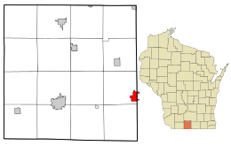 Location in Green County and the state of Wisconsin. | |
| Coordinates: 42°37′7″N 89°22′35″W / 42.61861°N 89.37639°WCoordinates: 42°37′7″N 89°22′35″W / 42.61861°N 89.37639°W | |
| Country | United States |
| State | Wisconsin |
| Counties | Green, Rock |
| Government | |
| • Mayor | Douglas Pinnow |
| Area[1] | |
| • Total | 1.84 sq mi (4.77 km2) |
| • Land | 1.84 sq mi (4.77 km2) |
| • Water | 0 sq mi (0 km2) |
| Elevation[2] | 794 ft (242 m) |
| Population (2010)[3] | |
| • Total | 3,293 |
| • Estimate (2012[4]) | 3,275 |
| • Density | 1,789.7/sq mi (691.0/km2) |
| Time zone | Central (CST) (UTC-6) |
| • Summer (DST) | CDT (UTC-5) |
| Zip Code | 53520 |
| Area code(s) | 608 |
| FIPS code | 55-09925[5] |
| GNIS feature ID | 1562229[2] |
| Website |
cityofbrodheadwi |
Brodhead is a city in Green and Rock counties in the U.S. state of Wisconsin. The population was 3,293 at the 2010 census. Of this, 3,203 were in Green County, and only 90 were in Rock County. In February 2000, the city annexed a portion of land from the Town of Spring Valley in Rock County.
History
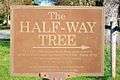
Just south of town is a historic marker for the Half-Way Tree, a bur oak supposedly identified by Native Americans as the halfway point on a foot trail between Lake Michigan and the Mississippi River.[6] The railroad track that runs east and west thru town features a small museum with a train and army tank on display, adjacent to the park and bandstand pavilion. The museum curator said that the railroad was being wooed by two different towns and decided to split the difference and created Brodhead. A nearby branch of the Sugar River was diverted along a canal to a small hydroelectric generator supplied by a small holding pond. This supposedly gave Brodhead the distinction of having electrical service before other larger cities such as Chicago, and perhaps the first electrical service in Wisconsin.[7]
Geography
Brodhead is located at 42°37′7″N 89°22′35″W / 42.61861°N 89.37639°W (42.618540, -89.376291).[8]
According to the United States Census Bureau, the city has a total area of 1.84 square miles (4.77 km2), all of it land.[1]
Brodhead School District
Grades Pre-K through fifth go to the Albrecht Elementary school. Grades sixth through eighth grade go to the Brodhead Middle School. Freshman through Seniors go to the Brodhead High School.[9] The schools are all located in a central location. The football field, softball, and baseball fields are right in the middle of the three schools, in a central location.
Demographics
| Historical population | |||
|---|---|---|---|
| Census | Pop. | %± | |
| 1870 | 1,548 | — | |
| 1880 | 1,254 | −19.0% | |
| 1890 | 1,461 | 16.5% | |
| 1900 | 1,584 | 8.4% | |
| 1910 | 1,517 | −4.2% | |
| 1920 | 1,600 | 5.5% | |
| 1930 | 1,533 | −4.2% | |
| 1940 | 1,750 | 14.2% | |
| 1950 | 2,016 | 15.2% | |
| 1960 | 2,444 | 21.2% | |
| 1970 | 2,515 | 2.9% | |
| 1980 | 3,153 | 25.4% | |
| 1990 | 3,165 | 0.4% | |
| 2000 | 3,180 | 0.5% | |
| 2010 | 3,293 | 3.6% | |
| Est. 2015 | 3,291 | [10] | −0.1% |
As of 2000 the median income for a household in the city was $36,506, and the median income for a family was $46,199. Males had a median income of $32,031 versus $24,442 for females. The per capita income for the city was $17,455. About 6.6% of families and 7.3% of the population were below the poverty line, including 4.1% of those under age 18 and 5.8% of those age 65 or over.
2010 census
As of the census[3] of 2010, there were 3,293 people, 1,346 households, and 851 families residing in the city. The population density was 1,789.7 inhabitants per square mile (691.0/km2). There were 1,452 housing units at an average density of 789.1 per square mile (304.7/km2). The racial makeup of the city was 96.4% White, 0.1% African American, 0.3% Native American, 0.5% Asian, 1.9% from other races, and 0.8% from two or more races. Hispanic or Latino of any race were 3.8% of the population.
There were 1,346 households of which 32.3% had children under the age of 18 living with them, 46.8% were married couples living together, 11.4% had a female householder with no husband present, 5.1% had a male householder with no wife present, and 36.8% were non-families. 31.1% of all households were made up of individuals and 14% had someone living alone who was 65 years of age or older. The average household size was 2.41 and the average family size was 3.01.
The median age in the city was 38.4 years. 25% of residents were under the age of 18; 7.9% were between the ages of 18 and 24; 26.1% were from 25 to 44; 23.3% were from 45 to 64; and 17.6% were 65 years of age or older. The gender makeup of the city was 47.3% male and 52.7% female.
Transportation
Wisconsin State Highways
 WIS 11 Run right through town as 1st Center Ave.
 WIS 81 Runs South of town.
 WIS 104 starts at the Northeast Corner of town.[12]
Railroads
The Wisconsin and Southern Railroad runs through town on the branch line to Monroe
Notable people
- Thax Douglas, poet, lives in Brodhead.[13]
- David Dunwiddie, Wisconsin state legislator, lived in Brodhead.[14]
- Milton S. Livingston, physicist, was born in Brodhead.[15]
- Harvey T. Moore, Vermont and Wisconsin state legislator, lived in Brodhead.[16]
- Henry Putnam, Wisconsin state legislator, was President of Brodhead.[17]
- Archibald N. Randall, Wisconsin state legislator[18]
- Burr Sprague, Wisconsin state legislator, lived in Brodhead.[19]
- Fred Ties, Wisconsin state legislator, lived in Brodhead.[20]
Gallery
-
-
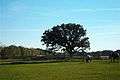
The Half-Way tree in Brodhead
-

Covered bridge 1½ miles North of Brodhead on the Sugar River State Trail
-

Covered bridge historic plate
References
- 1 2 "US Gazetteer files 2010". United States Census Bureau. Archived from the original on 2012-01-24. Retrieved 2012-11-18.
- 1 2 "US Board on Geographic Names". United States Geological Survey. 2007-10-25. Retrieved 2008-01-31.
- 1 2 "American FactFinder". United States Census Bureau. Retrieved 2012-11-18.
- ↑ "Population Estimates". United States Census Bureau. Archived from the original on 2013-06-17. Retrieved 2013-06-24.
- ↑ "American FactFinder". United States Census Bureau. Archived from the original on 2013-09-11. Retrieved 2008-01-31.
- ↑ JS Online: Don't look too closely at Half-Way Tree's roots Archived March 11, 2007, at the Wayback Machine.
- ↑ Contact the Brodhead Museum and Historical Society for details and verification.
- ↑ "US Gazetteer files: 2010, 2000, and 1990". United States Census Bureau. 2011-02-12. Retrieved 2011-04-23.
- ↑ Template:Brodhead School District
- ↑ "Annual Estimates of the Resident Population for Incorporated Places: April 1, 2010 to July 1, 2015". Retrieved July 2, 2016.
- ↑ "Census of Population and Housing". Census.gov. Archived from the original on May 11, 2015. Retrieved June 4, 2015.
- ↑ https://maps.google.com/maps?q=brodhead+wi&oe=utf-8&rls=org.mozilla:en-US:official&client=firefox-a&um=1&ie=UTF-8&hq=&hnear=0x88062b5d677763f9:0x9be1bff4acb9cd9b,Brodhead,+WI&gl=us&ei=JVIgTpyhCoXEgQeuj-3jBQ&sa=X&oi=geocode_result&ct=image&resnum=2&ved=0CCMQ8gEwAQ
- ↑ Thax Douglas on laying low in Wisconsin
- ↑ HISTORY OF GREEN COUNTY, WISCONSIN. Springfield, Ill.: Union Publishing Company. 1884. p. 292.
- ↑ M. Stanley Livingston
- ↑ 'Wisconsin Blue Book 1875,' Biographical Sketch of Harvey Thomas Moore, pg. 312
- ↑ Henry Clay Putnam
- ↑ 'Wisconsin Blue Book 1883,' Biographical Sketch of Archibald N. Randall, pg. 476-477
- ↑ 'Wisconsin Blue Book 1881,' Biographical Sketch of Birr Sprague, pg. 511
- ↑ 'Wisconsin Blue Book 1907, Biographical Sketch of Fred Ties, pg. 1151
External links
- City of Brodhead
- Sanborn fire insurance maps: 1908 1915
Municipalities and communities of Green County, Wisconsin, United States | ||
|---|---|---|
| Cities |  | |
| Villages | ||
| Towns | ||
| CDP | ||
| Unincorporated communities | ||
| Ghost towns | ||
| Footnotes | ‡This populated place also has portions in an adjacent county or counties | |
Municipalities and communities of Rock County, Wisconsin, United States | ||
|---|---|---|
| Cities | 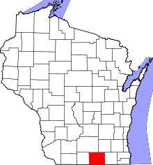 | |
| Villages | ||
| Towns | ||
| CDP | ||
| Unincorporated communities |
| |
| Ghost towns | ||
| Footnotes | ‡This populated place also has portions in an adjacent county or counties | |