Brazos Country, Texas
Not to be confused with Brazos County, Texas.
| Brazos Country, Texas | |
|---|---|
| City | |
 Brazos Country | |
| Coordinates: 29°45′14″N 96°03′02″W / 29.75389°N 96.05056°W | |
| Country | United States |
| State | Texas |
| County | Austin |
| Incorporated | 2000 |
| Area | |
| • Total | 2.1 sq mi (5.5 km2) |
| • Land | 2.1 sq mi (5.4 km2) |
| • Water | 0.04 sq mi (0.1 km2) |
| Population (2010) | |
| • Total | 469 |
| • Density | 226/sq mi (87.4/km2) |
| FIPS code | 48-10090 |
| GNIS feature ID | 1923026 |
| Website |
www |
Brazos Country is a city in Austin County, Texas. It is located south of Interstate 10 and 7 miles (11 km) southeast of Sealy. Downtown Houston is 43 miles (69 km) to the east. The eastern city limits of Brazos Country run along the west bank of the Brazos River. The only entrances to the city are from Chew Road. As of the 2010 census the population was 469.[1]
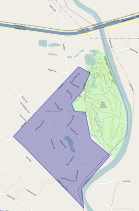
City Map, showing position from I-10
Development of the area began in the late 1970s, and the city was incorporated in May 2000.[2][3]
Demographics
| Historical population | |||
|---|---|---|---|
| Census | Pop. | %± | |
| 2010 | 469 | — | |
| Est. 2015 | 484 | [4] | 3.2% |
Government
City government is by mayor and city council. The Sealy Independent School District serves area students.
Brazos Country encompasses the River Ridge Golf Club[6] which occupies the west bank of the Brazos River.
References
- ↑ "Geographic Identifiers: 2010 Demographic Profile Data (G001): Brazos Country city, Texas". U.S. Census Bureau, American Factfinder. Retrieved August 26, 2013.
- ↑ "Boundary Changes". Geographic Change Notes: Texas. Population Division, United States Census Bureau. 2006-05-19. Archived from the original on 2010-08-06. Retrieved 2008-05-27.
- ↑ Brazos Country, Texas - Handbook of Texas.
- ↑ "Annual Estimates of the Resident Population for Incorporated Places: April 1, 2010 to July 1, 2015". Retrieved July 2, 2016.
- ↑ "Census of Population and Housing". Census.gov. Archived from the original on May 11, 2015. Retrieved June 4, 2015.
- ↑
External links
Municipalities and communities of Austin County, Texas, United States | ||
|---|---|---|
| Cities | 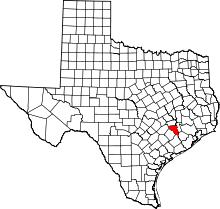 | |
| Town | ||
| Unincorporated communities | ||
| Ghost towns |
| |
| Footnotes | ‡This populated place also has portions in an adjacent county or counties | |
Coordinates: 29°45′14″N 96°03′02″W / 29.75389°N 96.05056°W
This article is issued from Wikipedia - version of the 11/7/2016. The text is available under the Creative Commons Attribution/Share Alike but additional terms may apply for the media files.