Brandsvold Township, Polk County, Minnesota
| Brandsvold Township, Minnesota | |
|---|---|
| Township | |
 Brandsvold Township, Minnesota Location within the state of Minnesota | |
| Coordinates: 47°37′23″N 95°44′33″W / 47.62306°N 95.74250°WCoordinates: 47°37′23″N 95°44′33″W / 47.62306°N 95.74250°W | |
| Country | United States |
| State | Minnesota |
| County | Polk |
| Area | |
| • Total | 35.4 sq mi (91.6 km2) |
| • Land | 34.5 sq mi (89.3 km2) |
| • Water | 0.9 sq mi (2.4 km2) |
| Elevation | 1,368 ft (417 m) |
| Population (2000) | |
| • Total | 241 |
| • Density | 7.0/sq mi (2.7/km2) |
| Time zone | Central (CST) (UTC-6) |
| • Summer (DST) | CDT (UTC-5) |
| FIPS code | 27-07390[1] |
| GNIS feature ID | 0663654[2] |
Brandsvold Township is a township in Polk County, Minnesota, United States. The population was 241 at the 2000 census. It is part of the Grand Forks-ND-MN Metropolitan Statistical Area.
Brandsvold Township was named for a Norwegian settler.[3]
Geography
Brandsvold Township is located near geocoordinates 47.65N, 95.745W.[4] According to the United States Census Bureau, the township has a total area of 35.4 square miles (92 km2), of which 34.5 square miles (89 km2) of it is land and 0.9 square miles (2.3 km2) of it (2.60%) is water.
Demographics
As of the census[1] of 2000, there were 241 people, 95 households, and 77 families residing in the township. The population density was 7.0 people per square mile (2.7/km²). There were 104 housing units at an average density of 3.0/sq mi (1.2/km²). The racial makeup of the township was 97.93% White, 0.83% Asian, and 1.24% from two or more races.
There were 95 households out of which 31.6% had children under the age of 18 living with them, 75.8% were married couples living together, 3.2% had a female householder with no husband present, and 18.9% were non-families. 18.9% of all households were made up of individuals and 11.6% had someone living alone who was 65 years of age or older. The average household size was 2.54 and the average family size was 2.88.
In the township the population was spread out with 25.3% under the age of 18, 4.1% from 18 to 24, 20.7% from 25 to 44, 35.3% from 45 to 64, and 14.5% who were 65 years of age or older. The median age was 45 years. For every 100 females there were 115.2 males. For every 100 females age 18 and over, there were 104.5 males.
The median income for a household in the township was $39,000, and the median income for a family was $44,063. Males had a median income of $26,875 versus $21,429 for females. The per capita income for the township was $15,094. About 5.8% of families and 9.8% of the population were below the poverty line, including 11.1% of those under the age of eighteen and 19.4% of those sixty five or over.
References
- 1 2 "American FactFinder". United States Census Bureau. Archived from the original on 2013-09-11. Retrieved 2008-01-31.
- ↑ "US Board on Geographic Names". United States Geological Survey. 2007-10-25. Retrieved 2008-01-31.
- ↑ Upham, Warren (1920). Minnesota Geographic Names: Their Origin and Historic Significance. Minnesota Historical Society. p. 422.
- ↑ Geocoordinates retrieved on 08-16-2006 from http://www.city-data.com/township/Brandsvold-Polk-MN.html
Municipalities and communities of Polk County, Minnesota, United States | ||
|---|---|---|
| Cities | 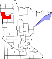 | |
| Townships |
| |
| Unincorporated communities | ||
| Indian reservation | ||
| Footnotes | ‡This populated place also has portions in an adjacent county or counties | |