Boury-en-Vexin
| Boury-en-Vexin | |
|---|---|
|
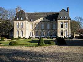
Château de Boury | |
 Boury-en-Vexin | |
|
Location within Hauts-de-France region  Boury-en-Vexin | |
| Coordinates: 49°14′30″N 1°44′13″E / 49.2417°N 1.7369°ECoordinates: 49°14′30″N 1°44′13″E / 49.2417°N 1.7369°E | |
| Country | France |
| Region | Hauts-de-France |
| Department | Oise |
| Arrondissement | Beauvais |
| Canton | Chaumont-en-Vexin |
| Intercommunality | Vexin Thelle |
| Government | |
| • Mayor (2008–2014) | Marie-Josée Depoilly |
| Area1 | 11.09 km2 (4.28 sq mi) |
| Population (2012)2 | 340 |
| • Density | 31/km2 (79/sq mi) |
| Time zone | CET (UTC+1) |
| • Summer (DST) | CEST (UTC+2) |
| INSEE/Postal code | 60095 / 60240 |
| Elevation | 37–141 m (121–463 ft) |
|
1 French Land Register data, which excludes lakes, ponds, glaciers > 1 km² (0.386 sq mi or 247 acres) and river estuaries. 2 Population without double counting: residents of multiple communes (e.g., students and military personnel) only counted once. | |
Boury-en-Vexin is a commune in the Oise department in northern France.
Population
| Historical population | ||
|---|---|---|
| Year | Pop. | ±% |
| 1793 | 387 | — |
| 1800 | 402 | +3.9% |
| 1806 | 428 | +6.5% |
| 1821 | 501 | +17.1% |
| 1831 | 522 | +4.2% |
| 1836 | 546 | +4.6% |
| 1841 | 582 | +6.6% |
| 1846 | 572 | −1.7% |
| 1851 | 501 | −12.4% |
| 1856 | 502 | +0.2% |
| 1861 | 479 | −4.6% |
| 1866 | 501 | +4.6% |
| 1872 | 466 | −7.0% |
| 1876 | 457 | −1.9% |
| 1881 | 413 | −9.6% |
| 1886 | 403 | −2.4% |
| 1891 | 406 | +0.7% |
| 1896 | 430 | +5.9% |
| 1901 | 432 | +0.5% |
| 1906 | 396 | −8.3% |
| 1911 | 365 | −7.8% |
| 1921 | 366 | +0.3% |
| 1926 | 381 | +4.1% |
| 1931 | 328 | −13.9% |
| 1936 | 310 | −5.5% |
| 1946 | 300 | −3.2% |
| 1954 | 304 | +1.3% |
| 1962 | 321 | +5.6% |
| 1968 | 282 | −12.1% |
| 1975 | 280 | −0.7% |
| 1982 | 289 | +3.2% |
| 1990 | 331 | +14.5% |
| 1999 | 307 | −7.3% |
| 2006 | 338 | +10.1% |
| 2009 | 342 | +1.2% |
| 2012 | 340 | −0.6% |
See also
References
| Wikimedia Commons has media related to Boury-en-Vexin. |
This article is issued from Wikipedia - version of the 3/15/2016. The text is available under the Creative Commons Attribution/Share Alike but additional terms may apply for the media files.