Blomkest, Minnesota
| Blomkest, Minnesota | |
|---|---|
| City | |
 Location of Blomkest, Minnesota | |
| Coordinates: 44°56′35″N 95°1′27″W / 44.94306°N 95.02417°W | |
| Country | United States |
| State | Minnesota |
| County | Kandiyohi |
| Area[1] | |
| • Total | 1.03 sq mi (2.67 km2) |
| • Land | 1.03 sq mi (2.67 km2) |
| • Water | 0 sq mi (0 km2) |
| Elevation | 1,135 ft (346 m) |
| Population (2010)[2] | |
| • Total | 157 |
| • Estimate (2012[3]) | 159 |
| • Density | 152.4/sq mi (58.8/km2) |
| Time zone | Central (CST) (UTC-6) |
| • Summer (DST) | CDT (UTC-5) |
| ZIP code | 56216 |
| Area code(s) | 320 |
| FIPS code | 27-06490[4] |
| GNIS feature ID | 0640267[5] |
Blomkest is a city in Kandiyohi County, Minnesota, United States. The population was 157 at the 2010 census.[6]
Geography
According to the United States Census Bureau, the city has a total area of 1.03 square miles (2.67 km2), all of it land.[1] The surrounding topography is marked by flat to slightly rolling fields, almost all of them farms. Big Kandiyohi Lake lies to the northeast of the town.
U.S. Route 71 and Minnesota State Highway 7 are two of the main routes in the community.
Town center
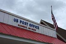
The downtown area of Blomkest spans three blocks. The main street is host to Erickson Plumbing & Heating Hardware store, Concorde Bank, post office, the former Blomkest Food Market, a restaurant under construction, the Blomkest Baptist Church, a steel construction company, the city park/fire department/community center & Dyrnwyn Studios, a multimedia production studio.
Demographics
| Historical population | |||
|---|---|---|---|
| Census | Pop. | %± | |
| 1960 | 171 | — | |
| 1970 | 172 | 0.6% | |
| 1980 | 200 | 16.3% | |
| 1990 | 183 | −8.5% | |
| 2000 | 186 | 1.6% | |
| 2010 | 157 | −15.6% | |
| Est. 2015 | 161 | [7] | 2.5% |
2010 census
As of the census[2] of 2010, there were 157 people, 68 households, and 53 families residing in the city. The population density was 152.4 inhabitants per square mile (58.8/km2). There were 72 housing units at an average density of 69.9 per square mile (27.0/km2). The racial makeup of the city was 95.5% White, 0.6% Asian, 0.6% from other races, and 3.2% from two or more races. Hispanic or Latino of any race were 6.4% of the population.
There were 68 households of which 25.0% had children under the age of 18 living with them, 73.5% were married couples living together, 1.5% had a female householder with no husband present, 2.9% had a male householder with no wife present, and 22.1% were non-families. 17.6% of all households were made up of individuals and 10.3% had someone living alone who was 65 years of age or older. The average household size was 2.31 and the average family size was 2.60.
The median age in the city was 49.9 years. 17.2% of residents were under the age of 18; 3.7% were between the ages of 18 and 24; 17.3% were from 25 to 44; 40.1% were from 45 to 64; and 21.7% were 65 years of age or older. The gender makeup of the city was 53.5% male and 46.5% female.
2000 census
As of the census[4] of 2000, there were 186 people, 66 households, and 53 families residing in the city. The population density was 179.8 people per square mile (69.7/km²). There were 70 housing units at an average density of 67.7 per square mile (26.2/km²). The racial makeup of the city was 96.77% White, 3.23% from other races. Hispanic or Latino of any race were 4.84% of the population.
There were 66 households out of which 43.9% had children under the age of 18 living with them, 71.2% were married couples living together, 7.6% had a female householder with no husband present, and 18.2% were non-families. 18.2% of all households were made up of individuals and 7.6% had someone living alone who was 65 years of age or older. The average household size was 2.82 and the average family size was 3.20.
In the city the population was spread out with 31.7% under the age of 18, 5.4% from 18 to 24, 32.3% from 25 to 44, 18.8% from 45 to 64, and 11.8% who were 65 years of age or older. The median age was 36 years. For every 100 females there were 93.8 males. For every 100 females age 18 and over, there were 98.4 males.
The median income for a household in the city was $34,583, and the median income for a family was $40,833. Males had a median income of $27,500 versus $26,000 for females. The per capita income for the city was $16,072. About 3.7% of families and 4.0% of the population were below the poverty line, including 2.0% of those under the age of eighteen and none of those sixty five or over.
References
- 1 2 "US Gazetteer files 2010". United States Census Bureau. Archived from the original on 2012-01-24. Retrieved 2012-11-13.
- 1 2 "American FactFinder". United States Census Bureau. Retrieved 2012-11-13.
- ↑ "Population Estimates". United States Census Bureau. Archived from the original on 2013-06-17. Retrieved 2013-05-28.
- 1 2 "American FactFinder". United States Census Bureau. Archived from the original on 2013-09-11. Retrieved 2008-01-31.
- ↑ "US Board on Geographic Names". United States Geological Survey. 2007-10-25. Retrieved 2008-01-31.
- ↑ "2010 Census Redistricting Data (Public Law 94-171) Summary File". American FactFinder. U.S. Census Bureau, 2010 Census. Archived from the original on 21 July 2011. Retrieved 27 April 2011.
- ↑ "Annual Estimates of the Resident Population for Incorporated Places: April 1, 2010 to July 1, 2015". Retrieved July 2, 2016.
- ↑ "Census of Population and Housing". Census.gov. Archived from the original on May 11, 2015. Retrieved June 4, 2015.
Municipalities and communities of Kandiyohi County, Minnesota, United States | ||
|---|---|---|
| Cities | 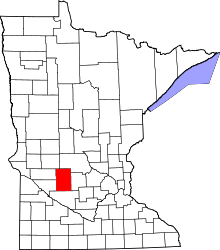 | |
| Townships | ||
| Unincorporated communities | ||
Coordinates: 44°56′34″N 95°01′24″W / 44.94278°N 95.02333°W