Bishopville, Maryland
| Bishopville, Maryland | |
|---|---|
| Census-designated place | |
 Bishopville | |
| Coordinates: 38°26′33″N 75°11′37″W / 38.44250°N 75.19361°WCoordinates: 38°26′33″N 75°11′37″W / 38.44250°N 75.19361°W | |
| Country | United States |
| State | Maryland |
| County | Worcester |
| Elevation | 10 ft (3 m) |
| Population (2010)[1] | |
| • Total | 531 |
| Time zone | Eastern (EST) (UTC-5) |
| • Summer (DST) | EDT (UTC-4) |
| ZIP code | 21813 |
| Area code(s) | 410, 443, and 667 |
| GNIS feature ID | 583255[2] |
Bishopville is a small unincorporated community and census-designated place 10 miles (16 km) north of Berlin in Worcester County, Maryland. The community is just south of the Delaware state line. It is part of the Salisbury, Maryland-Delaware Metropolitan Statistical Area. As of the 2010 census, it has a population of 531.[1]
Bishopville arose at the site of a mill on and crossing of the Bishopville Prong of the St. Martin's River. The crossing, the main road through the community, is now Maryland Route 367.
References
- 1 2 "American FactFinder". United States Census Bureau. Archived from the original on September 11, 2013. Retrieved January 7, 2016.
- ↑ "Bishopville". Geographic Names Information System. United States Geological Survey.
External links
| Wikimedia Commons has media related to Bishopville, Maryland. |
Municipalities and communities of Worcester County, Maryland, United States | ||
|---|---|---|
| City | 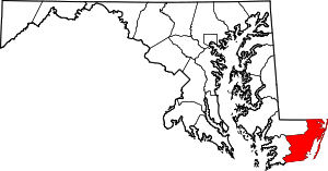 | |
| Towns | ||
| CDPs | ||
| Other communities | ||
| Footnotes | ‡This populated place also has portions in an adjacent county or counties | |
This article is issued from Wikipedia - version of the 11/3/2016. The text is available under the Creative Commons Attribution/Share Alike but additional terms may apply for the media files.