Beni, Dhaulagiri
| Beni Municipality बेनी नगरपालिका Beni Bazaar | |
|---|---|
| Municipality | |
| Motto: दुई खोलाको संगम | |
 Beni Municipality Location in Nepal | |
| Coordinates: 28°21′0″N 83°34′0″E / 28.35000°N 83.56667°ECoordinates: 28°21′0″N 83°34′0″E / 28.35000°N 83.56667°E | |
| Country |
|
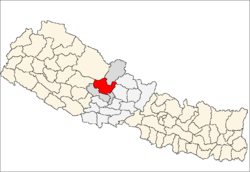
| Zone | Dhaulagiri Zone |
| District | Myagdi District |
| Area | |
| • Total | 52.77 km2 (20.37 sq mi) |
| Population (2011) | |
| • Total | 28,511 |
| • Density | 540/km2 (1,400/sq mi) |
| Time zone | NST (UTC+5:45) |
| Postal code | 33200 |
| Area code(s) | 069 |
| Website | http://benimun.gov.np/ |
Beni is a Municipality and the district headquarters of Myagdi District in Dhaulagiri Zone, Nepal. Municipality was announced by merging the then Ratnechaur, Jyamrukot, Arthunge, Ghatan, Pulachaur, Singa village development committees since 18 May 2014. [1]
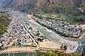
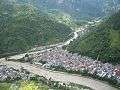
Beni is located at the confluence of the Kali Gandaki River and Myagdi River at an altitude of 899 meters. Being the northernmost of the Tri-cities area of Nepal, it is located 12 km to the north of Zonal headquarters Baglung. It is mainly divided into two parts by the Kali Gandaki River. The Western Part lies in Myagdi District and the main offices lie there. The other part lies in Parbat District and is relatively small.
History
Beni meaning the place where two rivers meet was the winter headquarters of Parvat Rajya. It was on the Tibet-Nepal trading route before the invasion of Parvat Rajya. [2]
Pictures
References
- ↑ Govt announces 72 new municipalities The Kathmandu Post
- ↑ Location of Beni - Falling Rain Genomics
External links
- UN map of the municipalities of Myagdi District
- Municipalities in Nepal: their Websites, Official Facebook Page & ICT