Beit Dajan, Nablus
This article is about the Palestinian village in the West Bank. For the destroyed Palestinian village near Jaffa, see Bayt Dajan.
| Beit Dajan | |
|---|---|
| Other transcription(s) | |
| • Arabic | بيت دجن |
| • Also spelled | Bayt Dajan (unofficial) |
 Beit Dajan Location of Beit Dajan within the Palestinian territories | |
| Coordinates: 32°11′31.70″N 35°22′16.11″E / 32.1921389°N 35.3711417°ECoordinates: 32°11′31.70″N 35°22′16.11″E / 32.1921389°N 35.3711417°E | |
| Palestine grid | 185/177 |
| Governorate | Nablus |
| Government | |
| • Type | Village council |
| • Head of Municipality | Nasr Khalil Abu Jeish |
| Population (2007) | |
| • Jurisdiction | 3,685 |
| Website | www.beitdajan.org.ps |
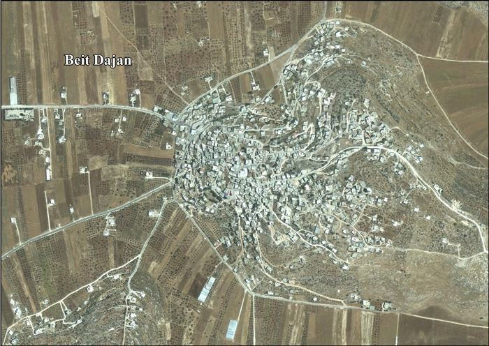
Beit Dajan (Arabic: بيت دجن) is a Palestinian town in the Nablus Governorate in the north central West Bank, located 10 kilometers (6.2 mi) east of Nablus. According to the Palestinian Central Bureau of Statistics, it had a population of approximately 3,589 in mid-year 2006.[1]
References
Bibliography
| Wikimedia Commons has media related to Beit Dajan, Nablus. |
- Barron, J. B., ed. (1923). Palestine: Report and General Abstracts of the Census of 1922. Government of Palestine.
- Conder, Claude Reignier; Kitchener, H. H. (1882). The Survey of Western Palestine: Memoirs of the Topography, Orography, Hydrography, and Archaeology. 2. London: Committee of the Palestine Exploration Fund. (pp. 229, 234)
- Dauphin, Claudine (1998). La Palestine byzantine, Peuplement et Populations. BAR International Series 726 (in French). III : Catalogue. Oxford: Archeopress. ISBN 0-860549-05-4. (p. 847)
- Department of Statistics (1945). Village Statistics, April, 1945. Government of Palestine.
- Finkelstein, Israel; Lederman, Zvi, eds. (1997). Highlands of many cultures. Tel Aviv: Institute of Archaeology of Tel Aviv University Publications Section. ISBN 965-440-007-3. (II p. 839)
- Guérin, Victor (1874). Description Géographique Historique et Archéologique de la Palestine (in French). 2: Samarie, pt. 1. Paris: L'Imprimerie Nationale. (pp. 454 -455)
- Hadawi, Sami (1970). Village Statistics of 1945: A Classification of Land and Area ownership in Palestine. Palestine Liberation Organization Research Center.
- Hütteroth, Wolf-Dieter; Abdulfattah, Kamal (1977). Historical Geography of Palestine, Transjordan and Southern Syria in the Late 16th Century. Erlanger Geographische Arbeiten, Sonderband 5. Erlangen, Germany: Vorstand der Fränkischen Geographischen Gesellschaft. ISBN 3-920405-41-2. (p. 130)
- Mills, E., ed. (1932). Census of Palestine 1931. Population of Villages, Towns and Administrative Areas. Jerusalem: Government of Palestine.
- Palmer, E. H. (1881). The Survey of Western Palestine: Arabic and English Name Lists Collected During the Survey by Lieutenants Conder and Kitchener, R. E. Transliterated and Explained by E.H. Palmer. Committee of the Palestine Exploration Fund. (p. 199)
- Saulcy, Louis Félicien de (1854). Narrative of a journey round the Dead Sea, and in the Bible lands, in 1850 and 1851. 1, new edition. London: R. Bentley. (Saulcy, 1854, vol 1, p. 99)
External links
- Welcome to Bayt Dajan
- Survey of Western Palestine, Map 12: IAA, Wikimedia commons
- Beit Dajan village profile, ARIJ
- Beit Dajan, aerial photo, ARIJ
- Beit Dajan
- Beit Dajan
| Cities |
|  |
|---|---|---|
| Municipalities | ||
| Villages |
| |
| Refugee camps | ||
This article is issued from Wikipedia - version of the 10/30/2016. The text is available under the Creative Commons Attribution/Share Alike but additional terms may apply for the media files.