Bear Tavern Road--Jacob's Creek Crossing Rural Historic District
|
Bear Tavern Road/Jacob's Creek Crossing Rural Historic District | |
|
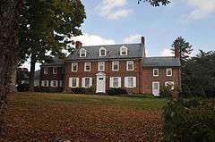
John Burroughs Farmstead (1800), 1132 Bear Tavern Road | |
   | |
| Location | Farms along Bear Tavern Road and intersection with Jacob's Creek Road in Hopewell Township and Ewing Township New Jersey |
|---|---|
| Coordinates | 40°17′54.2″N 74°50′51.1″W / 40.298389°N 74.847528°WCoordinates: 40°17′54.2″N 74°50′51.1″W / 40.298389°N 74.847528°W |
| Area | 395 acres (160 ha) |
| Built | 1729-1930 |
| Architect | Multiple |
| Architectural style | Georgian, Federal, Greek Revival |
| NRHP Reference # | 11000872 |
| NJRHP # | 5112[1] |
| Significant dates | |
| Added to NRHP | November 30, 2011 |
| Designated NJRHP | October 3, 2011 |
The Bear Tavern Road/Jacob's Creek Crossing Rural Historic District covers the farms along Bear Tavern Road north of its intersection with Jacob's Creek Road, as well as the bridge and intersection itself. Bear Tavern Road dates to 1729 and George Washington led the Continental Army along it in 1776, on his way from crossing the Delaware to the Battle of Trenton. The district still reflects its 18th and 19th century patterns of development.[2]
See also
References
- ↑ "New Jersey and National Registers of Historic Places — Mercer County" (PDF). New Jersey Department of Environmental Protection — Historic Preservation Office. January 22, 2015. Archived from the original (PDF) on 2013-05-16.
- ↑ Bertland, Dennis; Armstrong, Janice (October 2011). "Bear Tavern Road/Jacob's Creek Crossing Rural Historic District" (PDF). National Register of Historic Places. National Park Service.
This article is issued from Wikipedia - version of the 12/2/2016. The text is available under the Creative Commons Attribution/Share Alike but additional terms may apply for the media files.