Trenton Ferry Historic District
|
Trenton Ferry Historic District | |
|
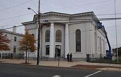
First Baptist Church, built 1858, the graveyard dates to revolutionary times | |
   | |
| Location | Roughly bounded by South Broad and Federal Streets, the Delaware River and the Amtrak Northeast Corridor in Trenton, New Jersey |
|---|---|
| Coordinates | 40°12′41.9″N 74°45′34.4″W / 40.211639°N 74.759556°W |
| Area | 69 acres (28 ha) |
| Built | 1704-1938 |
| Architect | John Notman (architect), Jonathan Doan (architect/builder), Robert Aitkin/William Johnson (builder) |
| Architectural style | Early Republic, Late Victorian |
| NRHP Reference # | 13000355 |
| NJRHP # | 4789[1] |
| Significant dates | |
| Added to NRHP | June 26, 2013 |
| Designated NJRHP | April 4, 2013 |
The Trenton Ferry Historic District is a historic mixed-use urban working class neighborhood primarily composed of modest row houses, schools, churches, and commercial buildings. The neighborhood has roots in the 18th century but the majority of its fabric dates to the 19th and early 20th centuries. The district has few modern intrusions and has retained its historic character.[2]
See also
References
- ↑ "New Jersey and National Registers of Historic Places — Mercer County" (PDF). New Jersey Department of Environmental Protection — Historic Preservation Office. January 22, 2015.
- ↑ Tvaryanas, Damon; Scott, Douglas; Hunter, Richard (November 26, 2012). "Trenton Ferry Historic District" (PDF). National Register of Historic Places. National Park Service.
This article is issued from Wikipedia - version of the 12/2/2016. The text is available under the Creative Commons Attribution/Share Alike but additional terms may apply for the media files.