Barholm
| Barholm | |
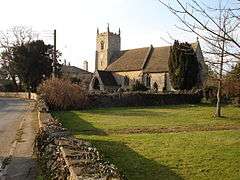 Church at Barholm |
|
 Barholm |
|
| OS grid reference | TF0910 |
|---|---|
| – London | 80 mi (130 km) S |
| District | South Kesteven |
| Shire county | Lincolnshire |
| Region | East Midlands |
| Country | England |
| Sovereign state | United Kingdom |
| Postcode district | PE9 |
| Police | Lincolnshire |
| Fire | Lincolnshire |
| Ambulance | East Midlands |
| EU Parliament | East Midlands |
|
|
Coordinates: 52°40′N 0°23′W / 52.67°N 00.38°W
Barholm /ˈbærəm/[1] is a village in the South Kesteven district of Lincolnshire, England. It is 2 miles (3 km) west from the A15 road, and 6 miles (10 km) south from Bourne.
Barholm is first recorded as "Berc(a)ham" in 1086; the name is from Old English beorg + hām or hamm and means "homestead or enclosure on a hill."[2]
Hereward (later known as Hereward the Wake) owned land in Barholm and the nearby village of Stow in the period before the Norman conquest in 1066.
The church received a new tower during the English Civil War and an inscription reads:
"Was ever such a thing
Since the Creation?
A new steeple built
In the time of vexation."
Local administration
Barholm is run through a parish meeting of its residents rather than a parish council, with two district councillors and a county councillor. The current district councillors are Kelham Cooke (Conservative) and Rosemary Woolley (Conservative).
References
- ↑ Miller, G.M., BBC Pronouncing Dictionary of British Names, Oxford University Press (1971), p. 11.
- ↑ Mills, A.D., Dictionary of English Place-Names, Oxford University Press, 2nd ed. (1998), p. 24.
External links
-
 Media related to Barholm at Wikimedia Commons
 - Barholm in the Domesday Book
England Portal | |
| Unitary authorities | |
| Boroughs or districts | |
| Major settlements |
|
| Topics | |