Baker, Minnesota
| Baker, Minnesota | |
|---|---|
| Census-designated place | |
 Baker, Minnesota | |
| Coordinates: 46°42′47″N 96°33′07″W / 46.71306°N 96.55194°WCoordinates: 46°42′47″N 96°33′07″W / 46.71306°N 96.55194°W | |
| Country | United States |
| State | Minnesota |
| County | Clay |
| Area[1] | |
| • Total | 1.009 sq mi (2.61 km2) |
| • Land | 1.009 sq mi (2.61 km2) |
| • Water | 0 sq mi (0 km2) |
| Elevation | 938 ft (286 m) |
| Population (2010)[2] | |
| • Total | 55 |
| • Density | 55/sq mi (21/km2) |
| Time zone | Central (CST) (UTC-6) |
| • Summer (DST) | CDT (UTC-5) |
| Area code(s) | 218 |
| GNIS feature ID | 639578[3] |
Baker is an unincorporated community and census-designated place in Clay County, Minnesota, United States. It lies roughly halfway between the cities of Sabin and Barnesville. As of the 2010 census, its population was 55.[2]
Baker, a railway village was named for Lester H. Baker,[4] a farmer who moved on to the state of Washington. The village was first settled in 1879, and the Great Northern Railway came in 1880. The first building was built in 1883 by John Erikson to store grain. The railroad in 1903 requested that the post office name be changed from Navan to Baker, to honor Lester Baker.
References
- ↑ "US Gazetteer files: 2010, 2000, and 1990". United States Census Bureau. 2011-02-12. Retrieved 2011-04-23.
- 1 2 "American FactFinder". United States Census Bureau. Archived from the original on 2013-09-11. Retrieved 2011-05-14.
- ↑ "Angle Inlet". Geographic Names Information System. United States Geological Survey.
- ↑ Upham, Warren (1920). Minnesota Geographic Names: Their Origin and Historic Significance. Minnesota Historical Society. p. 115.
Municipalities and communities of Clay County, Minnesota, United States | ||
|---|---|---|
| Cities | 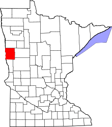 | |
| Townships | ||
| CDPs | ||
| Unincorporated communities | ||
| Ghost towns | ||
This article is issued from Wikipedia - version of the 10/24/2016. The text is available under the Creative Commons Attribution/Share Alike but additional terms may apply for the media files.