Ba'kelalan
| Ba'kelalan | |
|---|---|
 Ba'kelalan | |
| Coordinates: 3°59′44″N 115°37′21″E / 3.99556°N 115.62250°E | |
| Country |
|
| State |
|
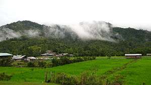
Ba'kelalan is a group of nine villages in the Bario Highlands of Limbang Division, Sarawak, Malaysia about 3,000 feet (910 m) above sea level and 4 km from the border with Indonesian Kalimantan. The villagers belong to the Lun Bawang tribe.[1] The villages are Buduk Nur, Long Langai, Long Lemumut, Long Ritan, Long Rusu, Pa Tawing, Buduk Bui, Buduk Aru and Long Rangat.[2][3]
The name Ba’Kelalan is derived from the Kelalan River and Ba’ which means wet lands in the Lun Bawang language. Its population is about 1203 but as many as 8000 call it home. In the cool mountain climate, temperate fruits such as apples, mandarin oranges and vanilla are grown.[4] The area also produces rice, and mountain salt is obtained from the nearby hills.[3] The people in Ba'Kelalan are Christian, members of the Sidang Injil Borneo, and rice production has doubled since the prohibition of alcohol.[5]
Ba'kelalan Airport has flights to Bario and to Lawas using 19-seater DHT aircraft. Road access is possible via a 125 km former logging trail from Lawas using four-wheel-drive vehicles, but the road conditions can be particularly bad in the rainy season and the journey takes at least six hours. However, in September 2009 the federal government of Malaysia approved RM50 million for the first construction phase of a road from Lawas to Ba’Kelalan to facilitate access.[6]
Tourism has increased in recent years: Ba'kelalan now has a 9-hole natural golf course, and the settlement is also the easiest point of access for visits to Kayan Mentarang National Park in Krayan, Kalimantan.[7]
Rice production
With water supply from the Kelalan river, the community have created well-irrigated padi fields in Buduk Bui and Long Langai, and grow the prized, small-grained “Highland Adan Rice” with fine, sweet grains. This is unusual in the mountainous interior of Sarawak, where most communities can only grow upland rice known as hill padi. Planting takes place each year in August and September, and harvesting starts in January.[8]
Apple farming
Apple farming has been developed in Ba'Kelalan since 1990. The town is the first in Malaysia to grow the fruit successfully on a commercial scale.
In 1975 the first apple cuttings were brought from the highlands of East Java by a local boy, Andrew Balang Paran. Early planting faced problems and it was not until 1988 that the turning point was brought about, when help from two apple growers from Batu Malang in Indonesia brought the 300 dying apple trees back to health using pruning, fertilisers and chemicals. During the next two years 1000 more apple trees were grown. In 1991 the first harvest was produced after an artificial "wintering" process in December 1990, when the leaves of the trees were removed.[9]
Now seven varieties of apple are grown, of which the first three have produced fruit:
- the 'Ba Kelalan Apple' or Manalagi, a Washington hybrid first produced in Indonesia, light green but turning yellow when ripe
- Rome Beauty, crunchy, sweet, sour tasting apple normally used for cooking
- Tropical Beauty, a brilliant red oval apple, sweet but not as crunchy as Rome Beauty
- Lady Williams
- Epal Anna
- Kwanglin
- Jonathan
The 3-hectare orchard has 2,000 apple trees and is run by 75-year-old former pastor Tagal Paran, the elder brother of Andrew Balang Paran who brought the first cuttings to the village, and his 50-year-old son Mutang Tagal. The trees bear fruit twice a year, normally in the middle and the end of the year.[10] Following the initial success, they plan to plant 4000 apple trees.[3] Most of the apples are transported to Lawas using the logging trail; some are sent to Kota Kinabalu in Sabah.
The first Apple Fiesta in Malaysia was held in Ba'Kelalan from 29 to 31 March 2007.[9] It has become an annual event and tourist attraction, based around the Apple Lodge in Buduk Nur. The third ran from 10 to 13 May 2009 and was titled "Ba'Kelalan: The Heart of Borneo Escapade 2009". The event is run by Borneo Jungle Safari (BJS) Sdn Bhd with support from Tourism Malaysia, Sarawak Tourism Board (STB), MASwings and Sarawak Tourism Action Council (STAC).[7]
Salt processing
Nearby salt water wells enable the community to produce an average of 40 kg of salt per week. The salt water is brought to the village and evaporated in a tank above a wood-fired stove; they take it in turns to stir the tank continuously for about five days as the crystals form and until the last water has been boiled away. About twenty four families are currently involved in salt production alongside their other farming activities. The salt well (or brine well) is used to mine salt from subterranean caverns or deposits by the use of water as a solution to dissolve the salt or halite deposits so that they can be extracted by pipe to an evaporation process that results in a brine or dry product for sale or use.[8]
References
- ↑ Ravichandran DJ Paul (5 April 2008). "Sweet home, Ba'Kelalan". The Brunei Times. Archived from the original on 31 August 2009. Retrieved 16 May 2008.
- ↑ Ardhana, I. Ketut; Langub, Jayl; Chew, Daniel (1 January 2004). "Borders of kinship and ethnicity: cross-border relations between the Kelalan Valley, Sarawak, and the Bawan Valley, East Kalimantan". Borneo Research Bulletin. Retrieved 5 August 2008.
- 1 2 3 Amrizan, Madian (2 June 2009). "Ba'kelalan, the "Wind Peak" of secrets". Sinchew-i. Retrieved 8 July 2009.
- ↑ "Post Ba'Kelalan Expedition 2006 - report 3". 2006. Archived from the original on 20 March 2008. Retrieved 14 May 2008.
- ↑ Keruah Usit (9 July 2009). "Church in Borneo". Hatena. Retrieved 9 July 2009.
- ↑ Joe Leong (23 September 2009). "Govt. Approves Funds for Lawas-Ba'kelalan Road". Borneopedia. Retrieved 24 September 2009.
- 1 2 Norni Mahadi (2009). "Ba'Kelalan to host Apple Fiesta". Eastern Times. Archived from the original on 1 June 2009. Retrieved 14 July 2009.
- 1 2 Joe Leong (3 August 2009). "Ba'kelalan People Live in 'Hidden Paradise'". Borneopedia. Retrieved 8 August 2009.
- 1 2 Philip Kiew (29 April 2007). "Ba Kelalan — apple of Sarawakian eyes". Borneo Post Online. Retrieved 14 May 2008.
- ↑ "In sync with apple cultivation". The Star Online. 14 May 2008. Retrieved 16 May 2008.
Coordinates: 3°59′44″N 115°37′21″E / 3.99556°N 115.62250°E
Capital: Kuching | |||||||||||||||||||||||
| Topics |
| ||||||||||||||||||||||
| Society |
| ||||||||||||||||||||||
| Administrative divisions |
| ||||||||||||||||||||||
| |||||||||||||||||||||||