B Line (RTD)
| B Line | |||||||||||||||||||||||||||||||||||||||||||||||||||||||||||||||||||||||||||||||||||||||||||||||||||||||||||||||||||||||||||||||||||||||||||||||||||||||||||||||||||||||||||||||||||||||
|---|---|---|---|---|---|---|---|---|---|---|---|---|---|---|---|---|---|---|---|---|---|---|---|---|---|---|---|---|---|---|---|---|---|---|---|---|---|---|---|---|---|---|---|---|---|---|---|---|---|---|---|---|---|---|---|---|---|---|---|---|---|---|---|---|---|---|---|---|---|---|---|---|---|---|---|---|---|---|---|---|---|---|---|---|---|---|---|---|---|---|---|---|---|---|---|---|---|---|---|---|---|---|---|---|---|---|---|---|---|---|---|---|---|---|---|---|---|---|---|---|---|---|---|---|---|---|---|---|---|---|---|---|---|---|---|---|---|---|---|---|---|---|---|---|---|---|---|---|---|---|---|---|---|---|---|---|---|---|---|---|---|---|---|---|---|---|---|---|---|---|---|---|---|---|---|---|---|---|---|---|---|---|---|
|
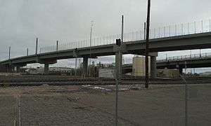
Bridge carrying B and G lines over freight lines and South Platte River | |||||||||||||||||||||||||||||||||||||||||||||||||||||||||||||||||||||||||||||||||||||||||||||||||||||||||||||||||||||||||||||||||||||||||||||||||||||||||||||||||||||||||||||||||||||||
| Overview | |||||||||||||||||||||||||||||||||||||||||||||||||||||||||||||||||||||||||||||||||||||||||||||||||||||||||||||||||||||||||||||||||||||||||||||||||||||||||||||||||||||||||||||||||||||||
| Type | Commuter Rail | ||||||||||||||||||||||||||||||||||||||||||||||||||||||||||||||||||||||||||||||||||||||||||||||||||||||||||||||||||||||||||||||||||||||||||||||||||||||||||||||||||||||||||||||||||||||
| System | Regional Transportation District | ||||||||||||||||||||||||||||||||||||||||||||||||||||||||||||||||||||||||||||||||||||||||||||||||||||||||||||||||||||||||||||||||||||||||||||||||||||||||||||||||||||||||||||||||||||||
| Status | Operating in truncated segment | ||||||||||||||||||||||||||||||||||||||||||||||||||||||||||||||||||||||||||||||||||||||||||||||||||||||||||||||||||||||||||||||||||||||||||||||||||||||||||||||||||||||||||||||||||||||
| Locale | Denver Metropolitan Area | ||||||||||||||||||||||||||||||||||||||||||||||||||||||||||||||||||||||||||||||||||||||||||||||||||||||||||||||||||||||||||||||||||||||||||||||||||||||||||||||||||||||||||||||||||||||
| Termini |
Union Station Westminster (initial) Downtown Longmont (proposed) | ||||||||||||||||||||||||||||||||||||||||||||||||||||||||||||||||||||||||||||||||||||||||||||||||||||||||||||||||||||||||||||||||||||||||||||||||||||||||||||||||||||||||||||||||||||||
| Stations |
2 (initial segment) 8 (proposed) | ||||||||||||||||||||||||||||||||||||||||||||||||||||||||||||||||||||||||||||||||||||||||||||||||||||||||||||||||||||||||||||||||||||||||||||||||||||||||||||||||||||||||||||||||||||||
| Website | Official website | ||||||||||||||||||||||||||||||||||||||||||||||||||||||||||||||||||||||||||||||||||||||||||||||||||||||||||||||||||||||||||||||||||||||||||||||||||||||||||||||||||||||||||||||||||||||
| Operation | |||||||||||||||||||||||||||||||||||||||||||||||||||||||||||||||||||||||||||||||||||||||||||||||||||||||||||||||||||||||||||||||||||||||||||||||||||||||||||||||||||||||||||||||||||||||
| Opened | July 25, 2016 | ||||||||||||||||||||||||||||||||||||||||||||||||||||||||||||||||||||||||||||||||||||||||||||||||||||||||||||||||||||||||||||||||||||||||||||||||||||||||||||||||||||||||||||||||||||||
| Owner | Regional Transportation District | ||||||||||||||||||||||||||||||||||||||||||||||||||||||||||||||||||||||||||||||||||||||||||||||||||||||||||||||||||||||||||||||||||||||||||||||||||||||||||||||||||||||||||||||||||||||
| Operator(s) | Denver Transit Partners | ||||||||||||||||||||||||||||||||||||||||||||||||||||||||||||||||||||||||||||||||||||||||||||||||||||||||||||||||||||||||||||||||||||||||||||||||||||||||||||||||||||||||||||||||||||||
| Rolling stock | Hyundai Rotem Silverliner V | ||||||||||||||||||||||||||||||||||||||||||||||||||||||||||||||||||||||||||||||||||||||||||||||||||||||||||||||||||||||||||||||||||||||||||||||||||||||||||||||||||||||||||||||||||||||
| Technical | |||||||||||||||||||||||||||||||||||||||||||||||||||||||||||||||||||||||||||||||||||||||||||||||||||||||||||||||||||||||||||||||||||||||||||||||||||||||||||||||||||||||||||||||||||||||
| Line length |
6.2 miles (10 km) (initial segment) 41 miles (66 km) (proposed) | ||||||||||||||||||||||||||||||||||||||||||||||||||||||||||||||||||||||||||||||||||||||||||||||||||||||||||||||||||||||||||||||||||||||||||||||||||||||||||||||||||||||||||||||||||||||
| Track gauge | 4 ft 8 1⁄2 in (1,435 mm) standard gauge | ||||||||||||||||||||||||||||||||||||||||||||||||||||||||||||||||||||||||||||||||||||||||||||||||||||||||||||||||||||||||||||||||||||||||||||||||||||||||||||||||||||||||||||||||||||||
| Electrification | Overhead lines, 25k V AC[1] 60 Hz | ||||||||||||||||||||||||||||||||||||||||||||||||||||||||||||||||||||||||||||||||||||||||||||||||||||||||||||||||||||||||||||||||||||||||||||||||||||||||||||||||||||||||||||||||||||||
| |||||||||||||||||||||||||||||||||||||||||||||||||||||||||||||||||||||||||||||||||||||||||||||||||||||||||||||||||||||||||||||||||||||||||||||||||||||||||||||||||||||||||||||||||||||||
The B Line, also known as the Northwest Rail Line during construction, is a commuter rail line which is part of the commuter and light rail system operated by the Regional Transportation District in the Denver Metropolitan Area in Colorado.[2] Part of the FasTracks project, the first 6.2-mile (10 km) section from downtown Denver to south Westminster opened on July 25, 2016.[3] When fully built out the B Line will be a 41-mile (66 km) high-capacity route from Denver Union Station to Longmont, passing through North Denver, Adams County, Westminster, Broomfield, Louisville and Boulder.[2]
Route
The B Line's southern terminus is at Union Station in Denver. It runs on a railroad right-of-way north sharing track with the G Line until the Pecos Station after which the two routes diverge. Initially, the B Line continues north to its terminus at Westminster Station;[4] this shuttle route is completed in approximately 11 minutes. It will not stop at either the 41st & Fox Station or the Pecos Junction Station,[2] both served by the G Line.
Stations
| Name | Opening Year | Interchange | Municipality / CDP | park-n-Ride? | Status |
|---|---|---|---|---|---|
| B Line (Union Station - Downtown Longmont) | |||||
| Union Station/ Lower Downtown (LoDo)/ Coors Field/16th Street Mall |
2014 | A & G Lines C , E , & W Lines FREE MallRide (16th St) |
Denver | No | Open |
| Westminster | 2016 | None | Westminster | Yes | Open |
| Church Ranch | TBA | None | Westminster | Yes | Proposed |
| Flatiron | TBA | None | Broomfield | Yes | Proposed |
| Louisville | TBA | None | Louisville | Yes | Proposed |
| Boulder Junction | TBA | None | Boulder | Yes | Proposed |
| Gunbarrel | TBA | None | Boulder | Yes | Proposed |
| Downtown Longmont | TBA | None | Longmont | Yes | Proposed |
FasTracks
In 2004, Colorado voters approved FasTracks, a multibillion-dollar public transportation expansion plan. The first segment of the B Line is under construction as part of the Eagle P3 project and is expected to open in 2016. The remaining segment, extending to downtown Longmont, will require additional funding in order to be completed prior to 2044.[5] The announcement angered many voters in the cities and suburbs north of Denver, who had approved a sales tax increase in 2004 to fund the FasTracks project.[6]
The downturn in the economy and significant cost increases and delays associated with building and operating Northwest Rail led to the initiation of the year-long "Northwest Area Mobility Study". This collaboration between northwest area governments and transportation partners created an alternative to the voter-approved commuter rail plan in order improve transportation in the short-term around the northwest area. The study concluded in 2014 and made a number of recommendations that were adopted by the RTD Board of Directors in June 2014 including a bus rapid transit system along U.S. Route 36 between Denver and Boulder.[7][8][9][10][11] This new system has been criticized as bus rapid transit creep.[12]
References
- ↑ "Commuter train testing begins on G Line". RTD FasTracks. Regional Transportation District of Denver. Retrieved 25 July 2016.
- 1 2 3 "RTD - B Line". Regional Transportation District. Retrieved June 22, 2015.
- ↑ Villanueva, Raquel; McGill, Nick (25 July 2016). "RTD unveils B-Line in Westminster". TEGNA, NBC. 9News KUSA-TV. Retrieved 25 July 2016.
- ↑ "RTD - Northwest Rail Line - Project Map". Regional Transportation District. Retrieved February 11, 2015.
- ↑ Regional Transport District. "Northwest Corridor FAQ". Regional Transport District. Retrieved 22 April 2013.
- ↑ Whaley, Monte (August 10, 2012). "RTD officials face legislative grilling over commuter rail delay". The Denver Post. Retrieved 22 April 2013.
- ↑ "Boulder council: RTD proposals have broad impacts". Boulder Daily Camera.
- ↑ "Boulder concerned about RTD transit plan along U.S. 36". Boulder Daily Camera.
- ↑ "RTD proposes cut of direct Boulder service". The Denver Post.
- ↑ "U.S. 36 reconstruction ongoing as is branding plan". The Denver Post.
- ↑ Whaley, Monte (February 4, 2013). "RTD foots bill for study of northwest transit system, cities sign on". The Denver Post. Retrieved 22 April 2013.
- ↑ "U.S. 36 bus transit plan is not what it seems, group says". The Denver Post.