Arrondissement of Arles
| Arles | |
|---|---|
| Arrondissement of France | |
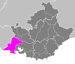 Location of Arles in Provence-Alpes-Côte d'Azur | |
| Country | France |
| Region | Provence-Alpes-Côte d'Azur |
| Department | Bouches-du-Rhône |
| Communes | 36 |
| Subprefecture | Arles |
| Area¹ | |
| • Total | 2,284 km2 (882 sq mi) |
| Population (2013) | |
| • Total | 202,919 |
| • Density | 89/km2 (230/sq mi) |
| ¹ French Land Register data, which exclude lakes, ponds, and glaciers larger than 1 km² as well as the estuaries of rivers. | |
The arrondissement of Arles is an arrondissement of France in the Bouches-du-Rhône department in the Provence-Alpes-Côte d'Azur region. It has 36 communes.
Composition
Cantons
The cantons of the arrondissement of Arles are:
- Arles
- Châteaurenard
- Pélissanne (partly)
- Salon-de-Provence-1 (partly)
Communes
The communes of the arrondissement of Arles, and their INSEE codes, are:
| 1. Alleins (13003) | 2. Arles (13004) | 3. Aureille (13006) | 4. Barbentane (13010) |
| 5. Boulbon (13017) | 6. Cabannes (13018) | 7. Châteaurenard (13027) | 8. Eygalières (13034) |
| 9. Eyguières (13035) | 10. Eyragues (13036) | 11. Fontvieille (13038) | 12. Graveson (13045) |
| 13. Lamanon (13049) | 14. Les Baux-de-Provence (13011) | 15. Maillane (13052) | 16. Mallemort (13053) |
| 17. Mas-Blanc-des-Alpilles (13057) | 18. Maussane-les-Alpilles (13058) | 19. Mollégès (13064) | 20. Mouriès (13065) |
| 21. Noves (13066) | 22. Orgon (13067) | 23. Paradou (13068) | 24. Plan-d'Orgon (13076) |
| 25. Port-Saint-Louis-du-Rhône (13078) | 26. Rognonas (13083) | 27. Saint-Andiol (13089) | 28. Saint-Martin-de-Crau (13097) |
| 29. Saint-Pierre-de-Mézoargues (13061) | 30. Saint-Rémy-de-Provence (13100) | 31. Saint-Étienne-du-Grès (13094) | 32. Saintes-Maries-de-la-Mer (13096) |
| 33. Sénas (13105) | 34. Tarascon (13108) | 35. Vernègues (13115) | 36. Verquières (13116) |
External links
Coordinates: 43°41′N 4°37′E / 43.683°N 4.617°E
This article is issued from Wikipedia - version of the 4/22/2016. The text is available under the Creative Commons Attribution/Share Alike but additional terms may apply for the media files.