Fontvieille, Bouches-du-Rhône
| Fontvieille | ||
|---|---|---|
|
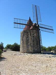
Alphonse Daudet's windmill | ||
| ||
 Fontvieille | ||
|
Location within Provence-A.-C.d'A. region  Fontvieille | ||
| Coordinates: 43°43′40″N 4°42′35″E / 43.7278°N 4.7097°ECoordinates: 43°43′40″N 4°42′35″E / 43.7278°N 4.7097°E | ||
| Country | France | |
| Region | Provence-Alpes-Côte d'Azur | |
| Department | Bouches-du-Rhône | |
| Arrondissement | Arles | |
| Canton | Arles-Est | |
| Government | ||
| • Mayor (2008–2014) | Guy Frustier | |
| Area1 | 40.18 km2 (15.51 sq mi) | |
| Population (2012)2 | 3,653 | |
| • Density | 91/km2 (240/sq mi) | |
| Time zone | CET (UTC+1) | |
| • Summer (DST) | CEST (UTC+2) | |
| INSEE/Postal code | 13038 / 13990 | |
| Elevation |
0–245 m (0–804 ft) (avg. 20 m or 66 ft) | |
|
1 French Land Register data, which excludes lakes, ponds, glaciers > 1 km² (0.386 sq mi or 247 acres) and river estuaries. 2 Population without double counting: residents of multiple communes (e.g., students and military personnel) only counted once. | ||

Fontvieille (Occitan: Fòntvielha) is a commune in the Bouches-du-Rhône department in southern France.
History
The commune was created in 1790, out of the territory of Arles.
Population
| Historical population | ||
|---|---|---|
| Year | Pop. | ±% |
| 1793 | 1,613 | — |
| 1800 | 1,900 | +17.8% |
| 1806 | 1,728 | −9.1% |
| 1821 | 2,044 | +18.3% |
| 1831 | 2,056 | +0.6% |
| 1836 | 2,165 | +5.3% |
| 1841 | 2,142 | −1.1% |
| 1846 | 2,402 | +12.1% |
| 1851 | 2,492 | +3.7% |
| 1856 | 2,479 | −0.5% |
| 1861 | 2,788 | +12.5% |
| 1866 | 3,248 | +16.5% |
| 1872 | 2,566 | −21.0% |
| 1876 | 2,565 | −0.0% |
| 1881 | 2,596 | +1.2% |
| 1886 | 2,840 | +9.4% |
| 1891 | 2,591 | −8.8% |
| 1896 | 2,541 | −1.9% |
| 1901 | 2,515 | −1.0% |
| 1906 | 2,252 | −10.5% |
| 1911 | 2,104 | −6.6% |
| 1921 | 2,027 | −3.7% |
| 1926 | 2,057 | +1.5% |
| 1931 | 2,079 | +1.1% |
| 1936 | 2,079 | +0.0% |
| 1946 | 2,064 | −0.7% |
| 1954 | 2,244 | +8.7% |
| 1962 | 2,388 | +6.4% |
| 1968 | 2,440 | +2.2% |
| 1975 | 2,935 | +20.3% |
| 1982 | 3,374 | +15.0% |
| 1990 | 3,642 | +7.9% |
| 1999 | 3,431 | −5.8% |
| 2008 | 3,533 | +3.0% |
Sights
- Alphonse Daudet's windmill
- Barbegal aqueduct and mill, a Roman watermill complex located on the territory of the commune
Twin towns
Fontvieille is twinned with Santa Maria a Monte, Italy, since 1991.
See also
References
External links
| Wikimedia Commons has media related to Fontvieille, Bouches-du-Rhône. |
This article is issued from Wikipedia - version of the 7/16/2016. The text is available under the Creative Commons Attribution/Share Alike but additional terms may apply for the media files.