Arkdale, Wisconsin
| Arkdale, Wisconsin | |
|---|---|
| Census-designated place | |
|
Looking north in Arkdale along WIS 21 | |
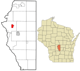 Location in Adams County and the state of Wisconsin. | |
| Coordinates: 44°01′38″N 89°53′16″W / 44.02722°N 89.88778°WCoordinates: 44°01′38″N 89°53′16″W / 44.02722°N 89.88778°W | |
| Country | United States |
| State | Wisconsin |
| County | Adams |
| Town | Strongs Prairie |
| Area[1] | |
| • Total | 2.221 sq mi (5.75 km2) |
| • Land | 2.144 sq mi (5.55 km2) |
| • Water | 0.077 sq mi (0.20 km2) |
| Elevation | 935 ft (285 m) |
| Population (2010)[2] | |
| • Total | 158 |
| • Density | 71/sq mi (27/km2) |
| Time zone | Central (CST) (UTC-6) |
| • Summer (DST) | CDT (UTC-5) |
| Area code(s) | 608 |
| GNIS feature ID | 1560396 |


Post office

Sign for Arkdale
Arkdale is an unincorporated census-designated place in the town of Strongs Prairie in Adams County, Wisconsin, United States.[3] As of the 2010 census, its population was 158.[2] Arkdale has an area of 2.221 square miles (5.75 km2); 2.144 square miles (5.55 km2) of this is land, and 0.077 square miles (0.20 km2) is water.
References
- ↑ "US Gazetteer files: 2010, 2000, and 1990". United States Census Bureau. 2011-02-12. Retrieved 2011-04-23.
- 1 2 "American FactFinder". U.S. Census Bureau. Archived from the original on 23 April 2011. Retrieved 29 March 2011.
- ↑ "Arkdale". Geographic Names Information System. United States Geological Survey.
External links
| Wikimedia Commons has media related to Arkdale, Wisconsin. |
Municipalities and communities of Adams County, Wisconsin, United States | ||
|---|---|---|
| Cities | 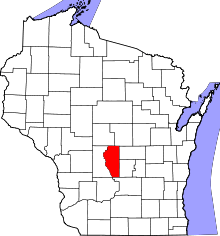 | |
| Village | ||
| Towns | ||
| CDPs | ||
| Unincorporated communities | ||
| Ghost towns | ||
| Footnotes | ‡This populated place also has portions in an adjacent county or counties | |
This article is issued from Wikipedia - version of the 10/21/2016. The text is available under the Creative Commons Attribution/Share Alike but additional terms may apply for the media files.