Arang
| Arang | |
|---|---|
| city | |
|
Three sculptures of Jain tirthankaras in the Bhand Dewal Temple | |
 Arang  Arang Location in Chhattisgarh, India | |
| Coordinates: 21°12′N 81°58′E / 21.2°N 81.97°ECoordinates: 21°12′N 81°58′E / 21.2°N 81.97°E | |
| Country | India |
| State | Chhattisgarh |
| District | Raipur |
| Area | |
| • Total | 23.49 km2 (9.07 sq mi) |
| Elevation | 267 m (876 ft) |
| Population (2001) | |
| • Total | 16,593 |
| • Density | 710/km2 (1,800/sq mi) |
| Languages | |
| • Official | Hindi, Chhattisgarhi |
| Time zone | IST (UTC+5:30) |
| Vehicle registration | CG |
Arang is a town and a Nagar Palika in Raipur District in the state of Chhattisgarh, India. It is situated near the eastern limits of Raipur City. Arang is an ancient town, which was ruled by the Haihayas Rajput dynasty. It is famous for its many Jain and Hindu temples which belong to the 11th and 12th centuries; these are the Bhand Deval Jain temple, the Mahamsmaya temple, the Panchamukhi temple and the Hanuman temple. Archaeological finds of a copper plate inscription dated to the Gupta Empire, known as the Arang Plate of Bhimasena II of the clan of Rajarsitulya, has established the town's ancient history as a Hindu and Jain religious centre, which was then under the rule of Hindu kings. The Bhand Deval Jain temple is the most ancient of these temples dated to 11th century where three huge images of Digambara tirthankaras are deified in the sanctum sanctorum; these are carved in black stone and polished.
Economic activity in the town is mostly related to small scale industries of rice and pulse mills, and many types of forest products. Religious tourism is receiving attention.
History
The name Arang is formed of two words ara meaning "saw" and anga meaning "body". According to a legend, king Moradhvaja of the Haihaya dynasty severed his son's body with a saw and offered it to the pet lion of the god Krishna at the latter's directive.[1]
Arang was ruled in ancient times by the Haihayas Rajput dynasty.[2] Archaeological finds establishes that the town had an ancient history as the centre of Hindu and Jain religious faiths.[3] Arang also finds mention in the Hindu epic Mahabharata.[4]
An archaeological antiquary in the form a copper plate inscription dated to the Gupta period, known as the Arang Plate of Bhimasena II of the clan of Rajarsitulya was unearthed at Arang. It attests to the reign of this dynasty over Chhattisgarh, particularly of Bhimasena II and five rulers who preceded him. It is inferred that they were vassals of the Gupta Empire.[5]
Archaeological finds in Arang also included few Jain images made of gem stones, which are now preserved in the Digambar Jain temple at Raipur.[6]
Another historical legend attributed to Arang in particular, and Chhattisgarh in general, relates to the princess Chandini and her lover Lorik. This legend is in the form of folk-poetry which is widely sung in the state. A memorial statue in their honour exists near Arang.[7]
Geography and climate
Arang, a prosperous ancient town, known for its many Jain and Hindu temples, is located on the west bank of the Mahanadi River, a Nagar Palika in Raipur District in Chhattisgarh,[1][2][3] at 21°12′N 81°58′E / 21.2°N 81.97°E. It has an average elevation of 267 metres (876 ft). It is 36 kilometres (22 mi) from Raipur on National Highway 6 (N.H.6), a four lane expressway to Durg passing through Arang. It is 15 kilometres (9.3 mi) from Mahasamund city.[8][9] There is also a two lane road from Arang to Tumgaon. The nearest airport is the Mana Airport near Raipur, which is 23.8 kilometres (14.8 mi) away from Arang.[10]
Climate
According to the Köppen-Geiger classification, Arang has a Temperate or subtropical hot-summer climate with nomenclature as Cwa. The average annual rainfall is 589 millimetres (23.2 in) with July and August recording the maximum. The average temperature is 22.2 °C (72.0 °F) with a maximum of 40.9 °C (105.6 °F) and a minimum of 3 °C (37 °F). June is the hottest month of the year with average temperature of 33.1 °C (91.6 °F) and January recording the lowest.[11]
| Climate data for Arang | |||||||||||||
|---|---|---|---|---|---|---|---|---|---|---|---|---|---|
| Month | Jan | Feb | Mar | Apr | May | Jun | Jul | Aug | Sep | Oct | Nov | Dec | Year |
| Record high °C (°F) | 18 (64) |
19.4 (66.9) |
24.5 (76.1) |
30.2 (86.4) |
36.2 (97.2) |
40.9 (105.6) |
37.5 (99.5) |
35.3 (95.5) |
34.7 (94.5) |
31.6 (88.9) |
25.6 (78.1) |
19.9 (67.8) |
40.9 (105.6) |
| Record low °C (°F) | 3 (37) |
5.9 (42.6) |
10.7 (51.3) |
15.5 (59.9) |
20.3 (68.5) |
25.3 (77.5) |
25.7 (78.3) |
24.7 (76.5) |
22.5 (72.5) |
15.3 (59.5) |
8.5 (47.3) |
3.8 (38.8) |
3 (37) |
| Average precipitation mm (inches) | 48 (1.89) |
49 (1.93) |
57 (2.24) |
40 (1.57) |
22 (0.87) |
25 (0.98) |
107 (4.21) |
136 (5.35) |
58 (2.28) |
12 (0.47) |
9 (0.35) |
26 (1.02) |
589 (23.16) |
| Source: Climate: Arang[11] | |||||||||||||
Demographics
As of 2001 India census,[12] Arang had a population of 16,593. Males constituted 51% of the population and females 49%. Arang had an average literacy rate of 64%, higher than the national average of 59.5%; with 60% of the males and 40% of females literate. 16% of the population is under 6 years of age.[12] As of 2011, the population reported was 19,091, an increase of 1.3% over the 2001 figure, which gives a density figure of 812.7/km² over the Nagar Panchayat area of 23.49 kilometres (14.60 mi).[13]
Economy
Economic activity is in the form of small scale industries of rice and pulses mills.[14] It is a commercial town where various types of forest products are marketed.[15]
Arang is one of the three locations chosen for community development in its Chandkhuri development block.[16]
Temples
Arang has many Jain and Hindu temples that are dated to the 11th and 12th centuries. Archaeological excavations carried out in the town has confirmed the town's ancient history as a Hindu and Jain religious centre, which prospered under the rule of Hindu kings.[3]
The ancient temples in Arang, which are tourist attractions are: the Baghdeval temple, the Bhanda Dewal temple, the Mahamaya temple, the Danteshwari temple, the Chandi Maheshwari temple, the Panchmukhi Mahadev temple, and the Panchmukhi Hanuman temple. Of these, the Bhand Dewal temple and Bagh Deval temple are particularly ancient and well-known.[3] Recently an idol of Adinath (Rishabhnatha) was excavated near this temple. This idol is 1.16 metres (3 ft 10 in) in height, 37 centimetres (15 in) in width and 21 centimetres (8.3 in) in thickness. This standing sculpture has a Yaksha and Yakshini near its knee region on two sides. The sculpture is dated to 5th-6th centuries AD.[17]
Bhand Dewal temple
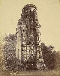
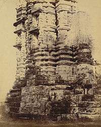
Bhand Dewal temple, a Jain temple dated to the late eleventh century, is in the Mahakosala area of Arang. It is built in the Bhumija style of architecture.[18] The plinth of this temple has detailed ornamentation. It has a socle plinth that supports a pedestal, and two rows of sculptures on the wall. The temple layout plan is in a star shape known as stellate (meaning: shaped like a star, having points, or rays radiating from a center) with six "offsets". The temple rises to five floors, which is considered an unusual feature.[1][18][19]
The temple faces west and is in rundown condition. In the past, a mandapa (an outdoor pavilion) and a porch probably existed as part of the temple. The damaged front fascia of the temple tower has been plastered without any decoration, and also white washed. The north-east and south-east faces of the temple tower, which were also dilapidated, have been redone in brick and mortar, but in a crude fashion. However, the overall view of the tower is still pleasing. At some stage, this temple was used as a survey marking station. As there was a tendency for the upper half of the tower to structurally burst by its seams, a metal strap bracing has been wound round the tower at the middle section to give it stability. A similar strap has been wound round at the top of the tower. The exterior faces of the temple have been embellished with carved images.[20]
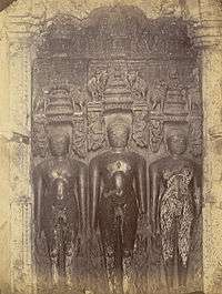
The temple has three free standing large images of Jain tirthankaras deified in the garbha griha or sanctum sanctorum.[19] These are carved ornately in black stone and highly polished. The three tirthankaras are Ajitanatha, Neminath and Shreyanasanatha.[21] The central figure is adorned with the symbol of a wheel holding two deers in the left hand, and a globe on the right hand. The base of this image has a "winged figure" carving. Carved images also embellish the exterior faces of the temple.[19]
A large number of images carved on the exterior and interior faces of the temple are erotic. The bigger images are carved in two lines. Above the lines of bigger images, a row of carvings of smaller images have been sculpted. At the base of the larger images is a row of highly decorated depiction of inscription panels, flowers and a royal march of horses, animals and people.[22]
It is a protected monument under the Raipur circle of Archaeological Survey of India, since 1920.[23]
Bagh Deval temple
Bagh Deval temple, which was inferred initially as a Jain temple, is dated to the 11th century. It has similar architectural features as the Khajuraho temple.[24][24]
Mahamaya temple
Mahamaya temple also has three very large images of tirthankaras. There is also a large single stone sculpture with images of all 24 tirthankaras carved on it.[25]
See also
- Champaran (Chhattisgarh), held sacred as the birthplace of Saint Vallabhacharya is nearby.
References
- 1 2 3 "Chattisgarh State". Rotary Club.
- 1 2 Garg 1992, p. 578.
- 1 2 3 4 Provinces 1909, p. 259.
- ↑ Surjan & Verma 1996, p. 18.
- ↑ Misra 2003, p. 8.
- ↑ Madhya Pradesh (India); V. S. Krishnan (1973). Madhya Pradesh District Gazetteers: Dewas. Government Central Press.
- ↑ Dube, S. C. (1947). "Field Songs Of Chhattisgarh". The Universal Publishers Ltd.
- ↑ Andhra Historical Research Society (1930). Journal of the Andhra Historical Society. Rajahmundry, Madras: Andhra Historical Research Society.
- ↑ "Arang". Falling Rain Genomics, Inc.
- ↑ "Closest Airport to Arang". Closestairportto.com. Retrieved 30 June 2016.
- 1 2 "Climate: Arang". Climate-Data Organization. Retrieved 31 August 2016.
- 1 2 "Census of India 2001: Data from the 2001 Census, including cities, villages and towns (Provisional)". Arang. Census Commission of India. Archived from the original on 2004-06-16. Retrieved 1 November 2008.
- ↑ "ARANG (Raipur)". City Population Organization.
- ↑ Dr. Lal & Jain (1 September 2010). Chhattisgarh Pre-B. Ed. Examination. Upkar Prakashan. pp. 1–. ISBN 978-81-7482-934-4.
- ↑ Deshmukh; I.C.S. (1 January 1996). Course Of My Life (Centenary ed.). Orient Blackswan. p. 70. ISBN 978-81-250-0824-8.
- ↑ Pradesh 1964, p. 59.
- ↑ "Ancient idol of Tirthankar Adinath found at Arang". The Hitavada. 19 May 2016. Retrieved 30 June 2016.
- 1 2 Jain 1972, p. 446.
- 1 2 3 Beglar, Joseph David (1873). "Three sculptures of Jain tirthankaras in the Bhand Dewal Temple, Arang". On Line Gallery British Library.
- ↑ Beglar, Joseph David (1873). "Ruins of the great Jain temple, Bhand Dewal, at Arang". Online Gallery of British Library.
- ↑ "Ganesh au Chattisgarh". Ganesh, dieu de l'hindouisme.
- ↑ Beglar, Joseph David (1873). "Close view of moulding at base of the tower of the Bhand Dewal Temple, Arang". Online gallery of British Library.
- ↑ "Centrally Protected Monuments/Sites/Remains, Archaeological Survey of India. Raipur Circle, Raipur" (PDF). ASI. Retrieved 10 February 2015.
- 1 2 Lalit Surjan; Vinod Verma (1996). Reference Deśabandhu Madhya Pradesh. Deshbandhu Publication Division. p. 249.
- ↑ "Tourist attractions around city". Chattisgarh Tourism.
Bibliography
| Wikivoyage has a travel guide for Arang. |
- Garg, Gaṅgā Rām (1992). Encyclopaedia of the Hindu World. Concept Publishing Company. ISBN 978-81-7022-376-4.
- Jain, Kailash Chand (1972). Malwa Through the Ages, from the Earliest Times to 1305 A.D. Motilal Banarsidass Publ. ISBN 978-81-208-0824-9.
- Kumar, Brajesh (2003). Pilgrimage Centres of India. Diamond Pocket Books (P) Ltd. ISBN 978-81-7182-185-3.
- Misra, Om Prakash (2003). Archaeological Excavations in Central India: Madhya Pradesh and Chhattisgarh. Mittal Publications. ISBN 978-81-7099-874-7.
- Pradesh, India (Republic). Superintendent of Census Operations, Madhya (1964). District Census Handbook, Madhya Pradesh, Census of India, 1961. Government of Madhya Pradesh.
- Provinces, Central (1909). Raipur district. Printed at the Pioneer Press.
- Surjan, Lalit; Verma, Vinod (1996). Reference Deśabandhu Madhya Pradesh. Deshbandhu Publication Division.