Appin (Bennettsville, South Carolina)
|
Appin | |
|
Appin | |
  | |
| Nearest city | Bennettsville, South Carolina |
|---|---|
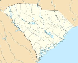
| Coordinates | 34°36′18″N 79°43′3″W / 34.60500°N 79.71750°WCoordinates: 34°36′18″N 79°43′3″W / 34.60500°N 79.71750°W |
| Built | 1875 (original); 1870 (increase) |
| Architectural style | Italianate (increase) |
| NRHP Reference # | 82003894 and 07001044[1] |
| Added to NRHP |
June 28, 1982 (original) October 3, 2007 (increase) |
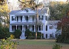
Appin near Bennettsville, South Carolina dates from 1875.[2][3] The boundaries of the listed property were increased to include more, perhaps outbuildings or secondary structures, dating from 1870, in 2007[4] It is a two-story farmhouse associated with its second owner, Charles Spencer McCall. He was a veteran of the Civil War, a local business man, mayor of Bennettsville, and member of the South Carolina Senate.[3]
It was listed on the National Register of Historic Places in 1982.[1]
References
- 1 2 National Park Service (2009-03-13). "National Register Information System". National Register of Historic Places. National Park Service.
- ↑ Pickens, Michelle A. (March 19, 2007). "Appin" (pdf). National Register of Historic Places - Nomination and Inventory. Retrieved 24 July 2012.
- 1 2 "Appin, Marlboro County (U.S. Hwy 15, Bennettsville vicinity)". National Register Properties in South Carolina. South Carolina Department of Archives and History. Retrieved 24 July 2012.
- ↑ Wylie, Suzanne Pickens; John Rogers; Pete Wells; Mrs. Catherine McCall (July 20, 1972). "Appin (Boundary Increase)" (pdf). National Register of Historic Places - Nomination and Inventory. Retrieved 24 July 2012.
| Topics |   | |
|---|---|---|
| Lists by county |
| |
| Lists by city | ||
| Other lists | ||
This article is issued from Wikipedia - version of the 11/27/2016. The text is available under the Creative Commons Attribution/Share Alike but additional terms may apply for the media files.