Ampatuan, Maguindanao
| Ampatuan | |
|---|---|
| Municipality | |
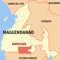 Map of Maguindanao showing the location of Ampatuan | |
.svg.png) Ampatuan Location within the Philippines | |
| Coordinates: 6°52′N 124°28′E / 6.867°N 124.467°ECoordinates: 6°52′N 124°28′E / 6.867°N 124.467°E | |
| Country |
|
| Region | Autonomous Region in Muslim Mindanao (ARMM) |
| Province | Maguindanao |
| Barangays | 11 |
| Government[1] | |
| • Mayor | Datu Rasul Sangki |
| Area | |
| • Total | 255.40 km2 (98.61 sq mi) |
| Population (2010) | |
| • Total | 17,800 |
| • Density | 70/km2 (180/sq mi) |
| Time zone | PST (UTC+8) |
| ZIP code | 9609 |
| Dialing code | +63 (0)64 |
| Income class | 4th |
Ampatuan is a 4th class municipality in the province of Maguindanao, Philippines. According to the 2010 census, it has a population of 17,800 people in 6,453 households.
Barangays
Ampatuan is politically subdivided into 11 barangays.[2]
- Dicalongan (Pob.)
- Kakal
- Kamasi
- Kapilpilaan
- Kauran
- Malatimon
- Matagabong
- Saniag
- Tomicor
- Tubak
- Salman
History
Ampatuan was created out of 23 barrios of Datu Piang on June 21, 1959 by Republic Act No. 2509.[3] On November 22, 1973, the municipality of Esperanza was carved out of its territory[4] and was made part of the province of Sultan Kudarat, while Ampatuan itself was made part of Maguindanao, when the old Cotabato province was divided into three provinces on the same date.[5] It further lost territory, when its electorate ratified on January 3, 2004, the separation of ten of its barangays to form the municipality of Datu Abdullah Sangki.[6]
The town was the site of the Maguindanao Massacre on November 23, 2009. The victims were about to file a certificate of candidacy for Esmael Mangudadatu, vice mayor of Buluan town for the province's gubernatorial election. Mangudadatu was challenging Andal S. Ampatuan, Jr. (son of the incumbent Maguindanao governor Datu Andal Ampatuan, Sr., the mayor of Datu Unsay, and accused of leading the massacre) in the election.The Municipal Officials were headed by Datu Zacaria S. Sangki Al-haj-Mayor, Datu Rasul M. Sangki-Vice Mayor, Sata Basilan-Budget Officer, Jose Bañaga-MPDC, Abdulrahman S. Sangki-Administrator, Datu Benjamier U. Mastura-Population Officer,Kungan Sangki-MSWDO,
Demographics
| Population census of Ampatuan | ||
|---|---|---|
| Year | Pop. | ±% p.a. |
| 1990 | 25,542 | — |
| 1995 | 27,200 | +1.19% |
| 2000 | 32,907 | +4.17% |
| 2007 | 33,702 | +0.33% |
| 2010 | 17,800 | −20.73% |
| Source: National Statistics Office[7] | ||
References
- ↑ "Official City/Municipal 2013 Election Results". Intramuros, Manila, Philippines: Commission on Elections (COMELEC). 1 July 2013. Retrieved 5 September 2013.
- ↑ National Statistical Coordination Board. "PSGC Interactive: Municipality/City: AMPATUAN". Retrieved 2008-05-19.
- ↑ Chan Robles Virtual Law Library (1998-07-19). "Republic Act No. 2509". Retrieved 2008-05-18.
- ↑ Chan Robles Virtual Law Library (1998-07-19). "Presidential Decree No. 339". Retrieved 2008-05-18.
- ↑ Chan Robles Virtual Law Library (1998-07-19). "Presidential Decree No. 341". Retrieved 2008-05-18.
- ↑ National Statistical Coordination Board (2004-08-22). "2004 Factsheet (January to July 2004)". Archived from the original on 15 June 2006. Retrieved 2006-06-24.
- ↑ "Total Population by Province, City, Municipality and Barangay: as of May 1, 2010". 2010 Census of Population and Housing. National Statistics Office. Retrieved 6 October 2013.
External links
- Philippine Standard Geographic Code
- Philippine Census Information
- Local Governance Performance Management System
 |
Talayan | Datu Unsay / Datu Hoffer Ampatuan / Shariff Aguak | | |
| South Upi | |
Datu Abdullah Sangki | ||
| ||||
| | ||||
| Lebak, Sultan Kudarat | Esperanza, Sultan Kudarat |