Amapá (municipality)
For other uses, see Amapa (disambiguation).
| Amapá | |
|---|---|
 Location of Amapá in Amapá State | |
| Coordinates: 02°03′10″N 50°47′34″W / 2.05278°N 50.79278°WCoordinates: 02°03′10″N 50°47′34″W / 2.05278°N 50.79278°W | |
| Country |
|
| Region | North |
| State | Amapá |
| Government | |
| • Mayor | Rildo Alaor Teixeira da Silva (PDT) |
| Area | |
| • Total | 3,540 sq mi (9,169 km2) |
| Elevation | 26 ft (8 m) |
| Population (2008) | |
| • Total | 7,745 |
| • Density | 2.09/sq mi (0.808/km2) |
| [1] | |
| Time zone | UTC-3 (UTC-3) |
| HDI (2000) | 0.72 – medium[2] |
Amapá is a municipality located in the easternmost portion of the state of Amapá in Brazil. Its population is 7,745 and its area is 9,169 square kilometres (3,540 sq mi).
The municipality is home to part of the Lago Piratuba Biological Reserve.[3] It also contains the Maracá-Jipioca Ecological Station, which covers two very low-lying islands just off the coast with rich biodiversity.[4] It contains 6.32% of the 2,369,400 hectares (5,855,000 acres) Amapá State Forest, a sustainable use conservation unit established in 2006.[5] It contains 3.08% of the 460,353 hectares (1,137,560 acres) Amapá National Forest, a sustainable use conservation unit created in 1989.[6]
References
- ↑ IBGE 2008 statistics
- ↑ "Archived copy". Archived from the original on 2009-10-03. Retrieved 2009-12-17. UNDP
- ↑ Unidade de Conservação: Reserva Biológica do Lago Piratuba, MMA: Ministério do Meio Ambiente, retrieved 2016-04-27
- ↑ Unidade de Conservação: Estação ecológica de Maracá-Jipioca (in Portuguese), MMA: Ministério do Meio Ambiente, retrieved 2016-04-16
- ↑ FES do Amapá (in Portuguese), ISA: Instituto Socioambiental, retrieved 2016-07-06
- ↑ FLONA do Amapá (in Portuguese), ISA: Instituto Socioambiental, retrieved 2016-07-06
Capital: Macapá | ||
| Amapá | 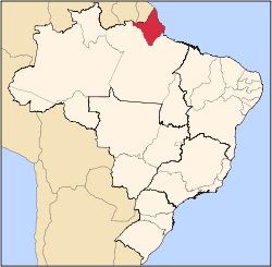 | |
| Macapá | ||
| Mazagão | ||
| Oiapoque | ||
This article is issued from Wikipedia - version of the 10/10/2016. The text is available under the Creative Commons Attribution/Share Alike but additional terms may apply for the media files.