Pedra Branca do Amapari
Coordinates: 00°46′46″N 51°56′56″W / 0.77944°N 51.94889°W
| Pedra Branca do Amapari | ||
|---|---|---|
| Municipality | ||
| Pedra Branca do Amapari | ||
| ||
 Location of Pedra Branca do Amapari in the Amapá | ||
 Pedra Branca do Amapari Location in Brazil | ||
| Coordinates: 00°46′46″N 51°46′46″W / 0.77944°N 51.77944°W | ||
| Country |
| |
| Region | North | |
| State |
| |
| Founded | July 9, 1890 | |
| Government | ||
| • Mayor | Genival Gemaque Santana (2013–2016) | |
| Area | ||
| • Total | 9,495 km2 (3,666 sq mi) | |
| Population (2014) | ||
| • Total | 13,411 | |
| • Density | 1.13/km2 (2.9/sq mi) | |
| Time zone | UTC-4 | |
| [1] | ||
Pedra Branca do Amapari (White Stone of Amaphary), also known simply as Amapari, is a municipality located in the midwest of the state of Amapá in Brazil.[1] Its population is 13,411 and its area is 9,495 square kilometres (3,666 sq mi). The municipality has a population density of 1.13/km2, and the population remains even divided between a rural and village areas.[1][2]
Geography
Pedra Branca do Amapari is bordered by the municipalities of Oiapoque to the north, Serra do Navio to the east, Porto Grande to the southeast, Mazagão to the south, and Laranjal do Jari to the west. The town is rich in rivers and streams (igarapé). The Amapari River and its tributaries, the Mururé, Tucumpi and Cupixi, all cross through the municipality. The Amapari River feeds in to the Araguari River in the southwest of the town.[1] The municipality contains 12% of the 806,184 hectares (1,992,120 acres) Rio Iratapuru Sustainable Development Reserve, created in 1997.[3] It contains 6.39% of the 2,369,400 hectares (5,855,000 acres) Amapá State Forest, a sustainable use conservation unit established in 2006.[4]
History
The municipality of Amapari was originally explored by members of the Samaracá, an indigenous group from French Guiana, who searched for gold in the area.[2] Manganese ore was discovered in the region in 1953. Travel to Pedra Branca do Amapari was possible only by airplane, and pilots used a huge white rock (pedra branca) in the Amapari River as a reference point. Thereafter the town was known as Pedra Branca do Amapari.[1]
Economy
Amapari supports the small-scale production of rice, corn, beans, and cassava for the domestic market. Cupuaçu, pineapples, oranges, bananas, and melons are grown for local consumption.[1] Per capital income in Amapari is R$ 24,782 (US$9629), as compared to the Brazilian national average of R$20,988 (US$12,536).[2][5]
References
- 1 2 3 4 5 6 Rodrigues, Edgar (2011). "Amapari" (in Portuguese). Macapá, Amapá: Governo do Estado do Amapá. Retrieved 2014-12-01.
- 1 2 3 "Pedra Branca do Amaparí" (in Portuguese). Brasília: Instituto Brasileiro de Geografia e Estatística. 2014. Retrieved 2014-12-01.
- ↑ RDS do Rio Iratapuru (in Portuguese), ISA: Instituto Socioambiental, retrieved 2016-11-05
- ↑ FES do Amapá (in Portuguese), ISA: Instituto Socioambiental, retrieved 2016-07-06
- ↑ "Brazil". International Monetary Fund (IMF). Retrieved 2014-12-06.
Capital: Macapá | ||
| Amapá | 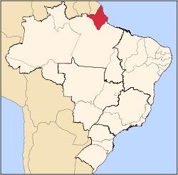 | |
| Macapá | ||
| Mazagão | ||
| Oiapoque | ||