Alberton, Queensland
| Alberton Gold Coast, Queensland | |||||||||||||
|---|---|---|---|---|---|---|---|---|---|---|---|---|---|
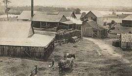 Alberton Sugar Mill, 1922 | |||||||||||||
| Population | 576 (2011 census)[1] | ||||||||||||
| Postcode(s) | 4207 | ||||||||||||
| LGA(s) | City of Gold Coast | ||||||||||||
| State electorate(s) | Albert, Coomera | ||||||||||||
| Federal Division(s) | Forde | ||||||||||||
| |||||||||||||
Alberton is a locality in the City of Gold Coast in Queensland, Australia.[2] According to the 2011 census it had a population of 576.[1] It is bounded in the north by the Logan River and in the west by its tributary, the Albert River.
History
The Aboriginal name for the area was Wobbomerijee (where Wobum means mud and Mudtheri means sticky).[2]
European settlement began in 1863 when the first settlers arrived, mostly German immigrants.[3] A town reserve was established in 1865 on the souther bank near the junction of the Logan and Albert Rivers.[4]
In 1869, the first Lutheran church was established near the Lutheran cemetery on Zipfs Road. The area was known as Elkana (meaning "God has created and blessed").[3][5] Later the area was called Alberton after Prince Albert, consort to Queen Victoria, but the name Elkana is preserved in Elkana Road.[6]

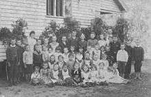
In 1870, a ferry service across the river was introduced with the first bridge being built in 1876 at Yatala.[3] A German school was established early in the 1870s beside the church. The Alberton Provisional School opened on 13 May 1876 with children attending German school on only one day a week. On 13 October 1884 the provisional school became the Alberton State School.[3][7] In 1886, a new larger Lutheran church (the present St Peter's at 187 Alberton Road) was built. It was consecrated in 1887 by Rev Hellmuth.[3]
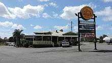
The Gem Hotel was established prior to 1911,[6] but it was destroyed by fire on 27 June 1933 but fortunately was insured.[8] By December 1933, the hotel had been rebuilt and was still operating in April 2014 on the corner of Stapylton-Jacobs Well Road and Rotary Park Road.[9][10]
The German school was demolished in 1919.[3] The Alberton State School closed in 1966.[7][11]
Economy
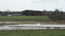
Alberton is primarily a rural area with sugar cane plantations and prawn farms.[6]
References
- 1 2 Australian Bureau of Statistics (31 October 2012). "Alberton (State Suburb)". 2011 Census QuickStats. Retrieved 2013-01-20.
- 1 2 "Alberton (entry 48111)". Queensland Place Names. Queensland Government. Retrieved 19 February 2014.
- 1 2 3 4 5 6 "History". Alberton Lutheran Parish. Retrieved 5 April 2014.
- ↑ "THE ALBERT RIVER.". The Brisbane Courier. National Library of Australia. 16 November 1865. p. 3. Retrieved 5 April 2014.
- ↑ "LOGAN PIONEERS.". The Brisbane Courier. National Library of Australia. 30 May 1914. p. 17. Retrieved 5 April 2014.
- 1 2 3 "Alberton History". City of Gold Coast Council. Retrieved 5 April 2014.
- 1 2 "Agency ID6326, Alberton State School". Queensland State Archives. Retrieved 5 April 2014.
- ↑ "FIRE AT ALBERTON.". The Brisbane Courier. National Library of Australia. 28 June 1933. p. 4. Retrieved 14 April 2014.
- ↑ "Classified Advertising.". The Courier-Mail. Brisbane: National Library of Australia. 11 November 1933. p. 5. Retrieved 14 April 2014.
- ↑ "Welcome". The Gem Hotel. Retrieved 14 April 2014.
- ↑ "Opening and closing dates of Queensland Schools". Queensland Government. Retrieved 4 April 2014.
External links
![]() Media related to Alberton, Queensland at Wikimedia Commons
Media related to Alberton, Queensland at Wikimedia Commons
Coordinates: 27°42′25″S 153°16′08″E / 27.7069°S 153.2689°E