Alamo Lake, Arizona
| Alamo Lake, Arizona | |
|---|---|
| Census-designated place | |
 Alamo Lake, Arizona | |
| Coordinates: 34°15′32″N 113°30′28″W / 34.25889°N 113.50778°WCoordinates: 34°15′32″N 113°30′28″W / 34.25889°N 113.50778°W | |
| Country | United States |
| State | Arizona |
| County | La Paz |
| Area[1] | |
| • Total | 46.562 sq mi (120.60 km2) |
| • Land | 43.939 sq mi (113.80 km2) |
| • Water | 2.623 sq mi (6.79 km2) |
| Elevation | 1,316 ft (401 m) |
| Population (2010)[2] | |
| • Total | 25 |
| • Density | 0.54/sq mi (0.21/km2) |
| Time zone | Mountain (MST) (UTC-7) |
| Area code(s) | 928 |
| GNIS feature ID | 2582722[3] |
Alamo Lake is a census-designated place in La Paz County, Arizona, United States. Its population was 25 as of the 2010 census.[2] The community includes Alamo Lake State Park.
References
- ↑ "US Gazetteer files: 2010, 2000, and 1990". United States Census Bureau. 2011-02-12. Retrieved 2011-04-23.
- 1 2 "American FactFinder". United States Census Bureau. Archived from the original on 2013-09-11. Retrieved 2011-05-14.
- ↑ "Alamo Lake Census Designated Place". Geographic Names Information System. United States Geological Survey.
Municipalities and communities of La Paz County, Arizona, United States | ||
|---|---|---|
| Towns | 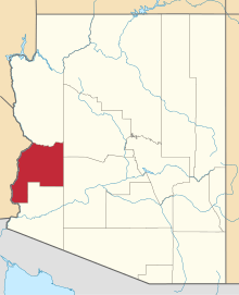 | |
| CDPs | ||
| Unincorporated communities | ||
| Indian reservations | ||
| Ghost towns | ||
This article is issued from Wikipedia - version of the 10/7/2016. The text is available under the Creative Commons Attribution/Share Alike but additional terms may apply for the media files.