Adelaide River
| Adelaide | |
| River | |
 The Adelaide River | |
| Name origin: Queen Adelaide | |
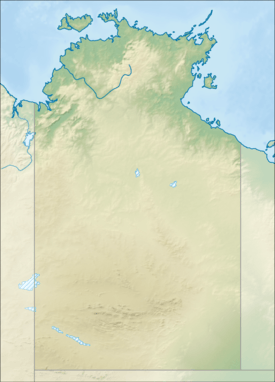
| Country | Australia |
|---|---|
| Territory | Northern Territory |
| Local government area | Coomalie, Litchfield |
| Townships | Adelaide River |
| Source | |
| - elevation | 149 m (489 ft) |
| Mouth | Adam Bay |
| - location | Clarence Strait |
| - elevation | 0 m (0 ft) |
| - coordinates | 12°13′S 131°14′E / 12.217°S 131.233°ECoordinates: 12°13′S 131°14′E / 12.217°S 131.233°E |
| Length | 238 km (148 mi) |
| Basin | 7,640 km2 (2,950 sq mi) |
| Discharge | |
| - average | 1,980 m3/s (69,923 cu ft/s) |
| National park | Litchfield National Park |
 | |
| [1][2] | |
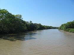
The Adelaide River is a river in the Northern Territory of Australia.
Course and features
The river rises in the Litchfield National Park and flows generally northwards to Clarence Strait, joined by eight tributaries including the west branch of the Adelaide River, Coomalie Creek, Margaret River and Marrakai Creek, before discharging into its mouth in Adam Bay in the Timor Sea. The river descends 151 metres (495 ft) over its 238-kilometre (148 mi) course.[1] The catchment area of the river is 7,640 square kilometres (2,950 sq mi).[2]
The Adelaide River is crossed by both the Stuart Highway adjacent to the township of Adelaide River and the Arnhem Highway near Humpty Doo.
The Adelaide River is well known for its high concentration of saltwater crocodiles, along with other wildlife including white-bellied sea eagles, whistling kites, freshwater crocodiles, bull sharks and Black Flying-fox. Its lower reaches form part of the Adelaide and Mary River Floodplains Important Bird Area.
A man named Fitzmaurice, under the command of John Lort Stokes, was the first European to discover the river when he sighted it when on a boating expedition. The expedition was part of the Admiralty surveying ship, 'The Beagle voyage in 1839 and it was named in memory of Queen Adelaide.[3]
Gallery
-

Jumping crocodile at Adelaide River
-
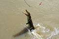
Croc whips tail to leap high but misses bait
-
A video taken on Adelaide River

See also
References
| Wikivoyage has a travel guide for Adelaide River. |
- 1 2 "Map of Adelaide River, NT". Bonzle Digital Atlas of Australia. Retrieved 27 April 2015.
- 1 2 Bach, Christine; Hosking, Jane (1 September 2002). "Wetland monitoring for the Mary River Catchment, Northern Territory" (PDF). Natural Heritage Trust. Retrieved 27 April 2015.
- ↑ "Place Names Register Extract - Adelaide River". NT Place Names Register. Northern Territory Government. Retrieved 27 April 2015.
River systems and rivers of the Northern Territory, Australia | |
|---|---|
| Floodplains | |
| Rivers |
|
| |