Abu Rummaneh
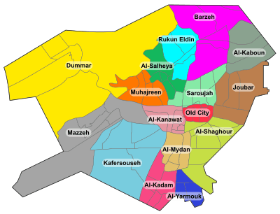
Abu Rummaneh (Arabic: أبو رمانة) is an upscale neighborhood and district of the Muhajirin municipality in western Damascus, Syria. It had a population of 6,421 in the 2004 census.[1] The quarter is centered on the palm-tree-lined Abu Rummaneh Boulevard, known officially as al-Jalaa Boulevard, named for the evacuation of French mandate troops from Syria. The neighborhood serves as Damascus' diplomatic quarter, also housing the Arab Cultural Center and the French Institute for Arab Studies (IFEAD). The smaller streets on either side of the boulevard are lined by expensive, old-money apartment buildings, owned by wealthy Damascenes.[2]
References
|
|---|
|
| |
|
| |
|---|
| | Districts: |
- Al-Abbas
- Barza al-Balad
- Ish al-Warwar
- Al-Manara
- Masakin Barzeh
- An-Nuzha
|
|---|
|
|
|
| |
|---|
| | Districts: |
- Al-Arin
- Dahiyet Dummar
- Dummar al-Gharbiyah
- Dummar al-Sharqiyah
- Al-Wuroud
|
|---|
|
|
|
| |
|---|
| | Districts: |
- Jobar Gharbi
- Jobar Sharqi
- Al-Istiqlal
- Al-Ma'muniyah
|
|---|
|
|
|
| |
|---|
| | Districts: |
- Fardos
- Al-Ikhlas
- Kafr Souseh al-Balad
- Al-Liwan
- Mezzeh al-Basatin
- Al-Waha
|
|---|
|
|
|
| |
|---|
| | Districts: |
- Al-Jalaa
- Fe'alat al-Gharbiyah
- Fe'alat al-Sharqiyah
- Mezzeh 86
- Mezzeh al-Qadimeh
- Mezzeh Jabal
- Al-Rabwa
- Al-Sumariyah
|
|---|
|
|
|
|
|
| Muhajirin |
|---|
| | Districts: |
- Abu Rummaneh
- A-Haboubi
- Al-Maliki
- Al-Marabit
- Al-Mastaba
- Al-Rawda
- Shura
|
|---|
|
|
|
| |
|---|
| | Districts: |
- Al-Masaneh'
- Qabun
- Tishrin
|
|---|
|
|
|
| |
|---|
| | Districts: |
- Al-Asali
- Dahadil
- Jouret al-Shreibati
- Al-Mustafa
- Al-Qadam
- Qadam Sharqi
- Al-Sayyidah Aisha
|
|---|
|
|
|
|
|
| |
|---|
| | Districts: |
- Asad ad-Din
- Ayyubiyah
- Al-Fayhaa
- Al-Naqshabandi
|
|---|
|
|
|
| |
|---|
| | Districts: |
- Abu Jarash
- Al-Madaris
- Al-Mazra'a
- Qasyoun
- Shaykh Muhyi ad-Din
- Ash-Shuhada
|
|---|
|
|
|
|
|
|
|
| |
|---|
| | Districts: |
- Al-Faluja
- Hittin
- Al-Karmil
- An-Naseriyah
- March 8th
- Al-Taqqadum
|
|---|
|
|