Barzeh, Syria
| Barzeh Arabic: مساكن | |
|---|---|
| Neighborhood | |
 | |
| Country | Syria |
| City | Damascus |
| Population (2004)[1] | |
| • Total | 47,339 |
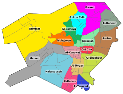
Barzeh (Arabic: مساكن, also written Berzé) is a municipality and a neighborhood to the north of Damascus, Syria.[2] According to the Syria Central Bureau of Statistics, Barzeh had a population of 47,339 in the 2004 census.[1]
History
The municipality has been active in the Syrian civil war. The Sunni Barzeh neighborhood is largely pro-opposition. However, the neighboring Alawite "slum" Esh al-Warwar is largely pro-government.[3][4] The Barzeh area has been under truce between the rebels and government since 2014.[3][5] On 1 April 2015, the rebels (Jaish al-Islam and the Free Syrian Army's First Brigade) launched a military campaign to expel the Islamic State from the Barzeh and Qaboun neighborhoods,[6][7] which ended in success three days later.[8] On 8 February 2016, an IS car bomb targeting a government officer's club killed eight people in Masakin Barzeh.[9]
Neighborhoods
- Al-Abbas (pop. 23,112)
- Barza al-Balad (pop. 31,634)
- Ish al-Warwar (pop. 20,458)
- Al-Manara (pop. 10,199)
- Masakin Barzeh (pop. 15,705)
- An-Nuzha (pop. 6,488)
References
- 1 2 Damascus city population
- ↑ Khaled Yacoub Oweis (18 July 2012). "Battles break out near Syrian presidential palace". Reuters. Retrieved 19 July 2012.
- 1 2 Lina Sinjab (18 January 2014). "In Syria, few conciliatory signs as peace talks loom". BBC. Retrieved 9 July 2016.
- ↑ Nir Rosen (12 October 2011). "Assad's Alawites: An Entrenched Community". Al-Jazeera. Retrieved 9 July 2016.
- ↑ Joshua Hersh (26 February 2014). "Syrian Government Sees An End Game, Block By Block". Huffington Post. Retrieved 9 July 2016.
- ↑ "ISIS encroaches on east Damascus". NOW. 17 April 2015. Retrieved 29 August 2016.
- ↑ "Damascus: Islam Army attacks ISIS bases in Qaboun, Barzeh neighborhoods". Zaman al-Wasl. 17 April 2015. Retrieved 29 August 2016.
- ↑ "Syrian rebels defeat ISIS in Damascus". Ara News. 20 April 2015. Retrieved 29 August 2016.
- ↑ Anne Barnard (9 February 2015). "ISIS, in a First, Says It Was Behind Attack in Syrian Capital". New York Times. Retrieved 29 August 2016.
Coordinates: 33°33′24″N 36°19′14″E / 33.55667°N 36.32056°E