A1237 road
| |
|---|---|
|
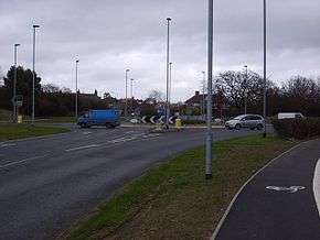
Roundabout at the junction of A1237 and Strensall Road | |
| Route information | |
| Length: | 10 mi (20 km) |
| Major junctions | |
| south east end: |
|
|
| |
| South west end: |
|
| Road network | |
The A1237 road is a road that runs to the west and north of the city of York, England. It forms part of the York Outer Ring Road as either end of the route forms junctions with the A64 to the south-west and east of the city to act as a city distributor. Construction began in 1984 and consisted of three distinct building phases. The road took three years to complete and has been subject since to studies looking to improve traffic flow and reduce accidents. The National Speed Limit for an A Class Road applies.
History
An outer ring road for York had been proposed as far back as 1948 by members of York City Council's Civic Committee. The scheme proposed by Adshead, Needham and Minter was grander in scale than currently exists. The northern section, based on junctions with the old A64 route, would have have started clockwise from the current A64 eastbound turn-off to Askham Richard and Bilbrough. It would have passed to the north west of Nether Poppleton and Skelton. It would still run south of Haxby and Wigginton, but continue more easterly than the current road to rejoin the A64 north of Stockton-on-Forest.[1]
The case for a solution to the increasing traffic management issues in the centre of the city of York during the 1960s were primarily to aid the local tourism industry. The first proposals were for an inner ring road that would be a dual carriageway. This met opposition as it would call for demolition of homes and many archaeological sites. This resulted in a public inquiry in 1972 that backed the inner ring road proposal, but the decision remained with the Secretary of State for the Environment, who eventually ruled against it in 1975, by which time the construction of the dual carriageway A64 was nearly complete.[2]
The inner ring road proposals were in contrast to 1958 report for the Minister for Housing and Local Government and the local council, by Lord Esher, entitled York: A Study in Conservation. This attempted to address modernising four English cities without undue impact on their heritage. The York Corporation, in contrast, still maintained their preference for the inner ring road, though this was subsequently limited to the current layout around the outside of the city walls.[3][4]
To cater for the numerous proposed developments on the outskirts of York, such as Clifton Moor, the decision was taken to construct a road to the west and north of York to link to the A64. This came out of evidence given to the 1972 Public Inquiry into the propose new Inner Ring Road. Studies conducted by Professor Smeed indicated an Outer Ring Road with radial roads was the best solution.[5]
The A1237 was the second part of the outer ring road and was constructed in three phases some 11 years after the first part, the A64 York Bypass, was completed. This was due to different organisations being responsible for the two roads and their strategic planning. The first phase of contruction started in 1984 on the northern section between the A19 and the A64. It opened in 1986. Phase two and three started construction in 1985 with the second and third sections opening the following year in September and December respectively. Phase two was between the A64 and the A59 and phase three was the short section between the A59 and A19. This section took longer to construct due to it having to cross the River Ouse and the East Coast Main Line. Phase three was opened by the Secretary of State for Transport Paul Channon on 11 December 1987.
Route

This is a single carriageway road, and has twelve roundabouts. Starting at the western end going clockwise, the road begins as one of the exits from the grade separated junction with the A64 exit for Copmanthorpe, Askham Bryan and York North. The last 1 mile section ends with the double roundabout at Hopgrove that links Malton Road and the A1237 with the A64 to complete the York Outer Ring Road.
| A1237 Road | |||
| Clockwise exits | Junction type | Distance from previous roundabout | Anti-clockwise exits |
| Askham Fields Lane | Roundabout | A64 (East and Westbound) | |
| Askham Bryan Lane | Roundabout | 1.2 miles | Askham Lane & Moor Lane |
| B1224 westbound to Wetherby | Roundabout | 1.4 miles | B1224 eastbound to Acomb |
| Give way | Main Street, Knapton | ||
| Moor Lane | Give way | ||
| A59 westbound to Knaresborough | Roundabout | 1.2 miles | A59 eastbound to Acomb |
| Roundabout | 0.7 miles | Great North Way Millfield Lane | |
| A19 northbound to Skelton | Roundabout | 0.8 miles | A19 southbound to Clifton & Rawcliffe Bar Park & Ride |
| Roundabout | 0.8 miles | Clifton Moor Gate | |
| B1363 northbound to Wigginton | Roundabout | 0.7 miles | B1363 southbound to York & Stirling Avenue |
| Haxby road northbound to Haxby | Roundabout | 0.8 miles | Haxby Road southbound to New Earswick |
| Strensall Road northbound to Earswick | Roundabout | 0.7 miles | Strensall Road southbound to Huntington |
| North Lane eastbound | Roundabout | 0.7 miles | Monks Cross Link & North Lane westbound |
| Malton Lane eastbound & A64 eastboound to Malton |
Roundabout | 1 mile | Malton Lane westbound to York |
Improvements
Implemented
In 2011 the roundabout on the A19 junction was upgraded at a cost of £1.2M and took about 12 weeks. Access and exits were widened; improved crossings; resurfacing and improved lighting and signage were done.[6]
In 2014, the roundabout that formed the junction between the ring road and the A59 was improved by York City Council in time for the 2014 Tour de France Stage 2 to pass over it.[7]
In 2015 the City Council in partnership with North Yorkshire Police, Joseph Rowntree Foundation and Joseph Rowntree School created a shared cycle/footpath by the ring road between the Haxby Road and Wigginton Road roundabouts.[8]
Proposed
Several bodies have proposed improvements to the A1237 including:
- Dualling the road by 2030 as detailed in the North Yorkshire Strategic Prospectus.[9]
- In the West Yorkshire Plus Transport Fund (York Schemes), improvements to seven roundabouts between the Wetherby Road and Monks Cross junctions. The design includes ensuring room for future dualling of the carriageways; increasing the number of approach and exit lanes at the roundabouts; enlarging their diameter; three subways for pedestrians/cyclists at busy crossing points and two bridges to accommodate a widened road.[10]
- On 3 March 2015 the Executive of York City Council resolved to progress Option 1 of the report into improvements to the York Outer Ring Road. This was to carry out the work recommended in the West Yorkshire Plus Transport Fund (York Schemes)[11]
Rejected
Congestion immediately became a problem, especially at peak times, and the 1989 Department for Transport's Roads for Prosperity white paper included improvements to the section between (A19to the A64). The proposals were for a new continuous through-route running parallel to the existing road with just a single grade separated junction at the B1363. The existing road, and the roundabouts, would have been retained for local access. The plans were subsequently dropped.[12]
Plans for dualling 7.8km, at a cost £31M, of the A1237 York Outer Ring Road were rejected by the Regional Transport Board in 2009.[13]
Traffic studies
Congestion at peak times remains an issue and has led to studies that show that delays at all junctions will lead to an increase in journey times ranging between two to three times longer compared to 2003. A study from March 2001 and February also recorded 172 accidents, of which 21 were serious and 5 involved a fatality.[14]
References
- ↑ "1948 Plan fotr the City of York" (PDF). York Civic Trust. Retrieved 26 Nov 2016.
- ↑ Nigel D Morpeth & Honliang Yan, ed. (2015). Planning for Tourism: Towards a Sustainable Future (CABI Tourism Texts). CABI. ISBN 1-780-64458-2.
- ↑ Paul Chrystal (2015). York in the 1960s: Ten years that Changed a City. Amberley Publishing Ltd. pp. 101–104. ISBN 1-445-64096-1.
- ↑ Nathaniel Lichfield & Alan Proudlove (1076). Conservation and traffic: A Case Study of York. Sessions Book Trust. pp. 23, 51 & 54. ISBN 0-900-65723-5.
- ↑ "Evidence to York Inner Ring Road 1972 Public Inquiry" (PDF). Retrieved 27 Nov 2016.
- ↑ Claire Bottomley (22 Dec 2010). "Outer Ring Road improvements". Southern Daily Echo. Retrieved 27 Nov 2016.
- ↑ "CES Capital Program Report". City of York Council. Retrieved 27 Nov 2016.
- ↑ "New cycle track opens". City of York Council. Retrieved 27 Nov 2016.
- ↑ "North Yorkshire Strategic Prospectus" (PDF). North Yorkshire County Council. Retrieved 27 Nov 2016.
- ↑ "West Yorkshire Plus Transport Fund (York Schemes)" (PDF). West Yorkshire Council. Retrieved 27 Nov 2016.
- ↑ "York Outer Ring Road Improvement Scheme". City of York Council. Retrieved 27 Nov 2016.
- ↑ "Nationwide list of dropped schemes". The Independent. 30 Mar 1994. Retrieved 27 Nov 2016.
- ↑ "Better Transport UK". Campaign for Better Transport. Retrieved 27 Nov 2016.
- ↑ "A1237 Outer Ring Road improvements study (Annex 1)" (PDF). City of York Council. Retrieved 27 Nov 2016.
A roads in Zone 1 of the Great Britain road numbering scheme | ||
|---|---|---|
| ||