2016–17 Australian region cyclone season
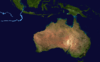 | |
| Season summary map | |
| First system formed | 23 September 2016 |
|---|---|
| Last system dissipated | Season ongoing |
| Strongest storm1 | Tropical Low – 1003 hPa (mbar), |
| Tropical lows | 6 |
| Total fatalities | None |
| Total damage | None |
| 1Strongest storm is determined by lowest pressure | |
2014–15, 2015–16, 2016–17, 2017–18, 2018–19 | |
| Related articles | |
The 2016–17 Australian region cyclone season is the period of the year when most tropical cyclones form in the Southern Indian Ocean and Pacific Oceans between 90°E and 160°E. The season will officially run from 1 November 2016 to 30 April 2017, however, a tropical cyclone could form at any time between 1 July 2016 and 30 June 2017 and would count towards the season total. During the season, tropical cyclones will be officially monitored, by one of the five Tropical Cyclone Warning Centres (TCWCs) that operate in this region. Three of the five centers are operated by the Australian Bureau of Meteorology (BoM) in Perth, Darwin, and Brisbane, while the other two are operated by the National Weather Service of Papua New Guinea in Port Moresby and the Indonesian Agency for Meteorology, Climatology and Geophysics in Jakarta, Indonesia. The United States Joint Typhoon Warning Center (JTWC) and other national meteorological services including Météo-France will also monitor the basin during the season.
Seasonal forecasts
| Region | Average number |
Chance of more |
Chance of less |
Actual activity |
|---|---|---|---|---|
| Whole | 11 | 67% | 33% | None |
| Western | 7 | 59% | 41% | None |
| North-Western | 5 | 63% | 37% | None |
| Northern | 3 | 56% | 44% | None |
| Eastern | 4 | 58% | 42% | None |
| Source: BOM's Seasonal Outlooks for Tropical Cyclones.[1] | ||||
After the least active season on record had occurred during the previous season, the BoM issued five tropical cyclone outlooks for the Australian region during October 2016. Each one of these forecasts was for the entire tropical cyclone year between July 2016 and June 2017 took into account various factors, including the latest neutral to weak La Niña conditions that had been observed in the tropical Pacific Ocean. The outlooks indicated that an above-average number of tropical cyclones were likely for the basin as a whole and the Northwestern sub-region. It was also predicted that the first tropical cyclone landfall on Australia would take place during December 2016. For the Western region between 90°E and 125°E, the BoM forecast that the area would also see activity near its average of 7, with a 59% chance of an above average number of tropical cyclones occurring.[1] TCWC Perth also noted that there was a likelihood of two tropical cyclones and a significant likelihood of at least one severe tropical cyclone impacting Western Australia.[2] They also noted that the number of significant cyclones and flood impacts had been well below average over the last five seasons.[2] For the North-Western subregion between 105°E and 130°E, it was predicted that activity would be above average, with a 63% chance of above average tropical cyclone activity.[1] The Northern Territory which was defined as being between as being 125°E and 142.5°E had a 56% chance of an above average season.[1] The Eastern region between 142.5°E and 160°E was predicted to have a near normal tropical cyclone season, with a 58% chance of above average tropical cyclone activity.[1]
Seasonal summary
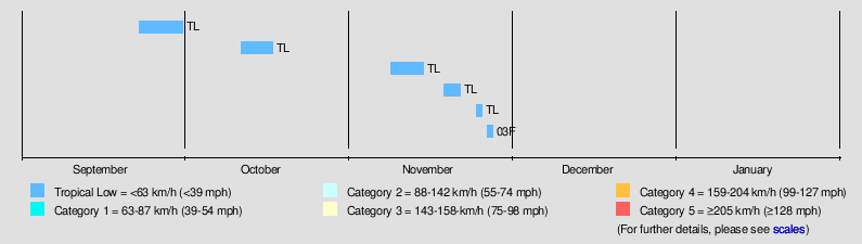
The 2016–17 season opened with a tropical system over in the Western Region on 23 September, just more than a month before the official start of the season.
Storms
Tropical Low
| Tropical low (Australian scale) | |||
|---|---|---|---|
| |||
| Duration | 9 November – 15 November | ||
| Peak intensity | Winds not specified 1005 hPa (mbar) | ||

On 9 November, TCWC Perth started to monitor another tropical low.[3] By 11 November, the JTWC classified it with a "low" chance of developing a tropical cyclone with scattered convection wrapping into its center as it was located about 620 km (385 mi) to the northwest of the Cocos (Keeling) Islands.[4] TCWC Perth also stated that it had a chance of becoming a tropical cyclone.[5] After meandering in unfavorable environments, TCWC Perth issued its final bulletin during 15 November.[6]
Tropical Low 03F
| Tropical low (Australian scale) | |||
|---|---|---|---|
| |||
| Duration | 27 November – 28 November | ||
| Peak intensity | Winds not specified | ||

On 27 November, TCWC Brisbane had started monitoring on a tropical low over in the Solomon Islands. Though due to lack of organization, the system was not expected to become a tropical cyclone as the agency issued its final bulletin on the next day. The system, as a low, moved out of the basin and was classified by RSMC Nadi as Tropical Disturbance 03F on 29 November.
Other systems
During 23 September a weak tropical low developed to the northwest of Christmas Island within a monsoon trough, however, the system was forecast not to develop further.[7] After moving southeastward for several days, TCWC Perth issued its final bulletin on the tropical low and dissipated during 30 September.[8] On 12 October, a weak tropical low had developed about 426 km (266 mi) west-southwest of Jakarta with a high chance of intensifying into a tropical cyclone.[9][10] By October 15, due to moderate shear, TCWC Perth had lowered their chance of strengthening into a tropical cyclone.[11][12] The system meandered westward in a couple of days until it was last mentioned in their bulletin on 18 October. On 19 November, TCWC Brisbane had stated that a transient tropical low had developed over in the Coral Sea.[13] After moving southwestward, the system had weakened into a weak low early on 22 November. On 25 November, TCWC Perth started monitoring a weak tropical to the southwest of Lampung.[14] By the next day, it had moved north into TCWC Jakarta's area of responsibility. However, they did not mention the system again within their next advisory.
Storm names
TCWC Jakarta
TCWC Jakarta monitors Tropical Cyclones from the Equator to 11S and from 90E to 145E. Should a Tropical Depression reach Tropical Cyclone strength within TCWC Jakarta's Area of Responsibility then it will be assigned the next name from the following list.[15]
| Cempaka (unused) | Dahlia (unused) | Flamboyan (unused) | Kenanga (unused) | Lili (unused) |
| Mawar (unused) | Seroja (unused) | Teratai (unused) | Anggrek (unused) | Bakung (unused) |
TCWC Port Moresby
Tropical cyclones that develop north of 11°S between 151°E and 160°E are assigned names by the Tropical Cyclone Warning Centre in Port Moresby, Papua New Guinea. Tropical cyclone formation in this area is rare, with no cyclones being named in it since 2007.[16] As names are assigned in a random order the whole list is shown below.
| Alu (unused) | Buri (unused) | Dodo (unused) | Emau (unused) | Fere (unused) |
| Hibu (unused) | Ila (unused) | Kama (unused) | Lobu (unused) | Maila (unused) |
Bureau of Meteorology
Since the start of the 2008–09 season, there has only been one list that the Bureau of Meteorology have assigned names to tropical cyclones from.[15] However, the Bureau of Meteorology still operates the various TCWCs in Perth, Darwin & Brisbane. These monitor all tropical cyclones that form within the Australian region, including any in either TCWC Jakarta's or Port Moresby's area of responsibility. The next 12 names on the naming list are listed here below.
| Yvette (unused) | Alfred (unused) | Blanche (unused) | Caleb (unused) | Debbie (unused) | Ernie (unused) |
| Frances (unused) | Greg (unused) | Hilda (unused) | Irving (unused) | Joyce (unused) | Kelvin (unused) |
Season effects
| Name | Dates active | Peak classification |
Sustained wind speeds |
Pressure | Land areas affected | Damages (AUD) |
Damages (USD) |
Deaths | Refs |
|---|---|---|---|---|---|---|---|---|---|
| Low | 23 – 30 September | Tropical low | Not specified | 1006 hPa (29.71 inHg) | None | None | None | None | |
| Low | 12 – 18 October | Tropical low | Not specified | 1004 hPa (29.65 inHg) | None | None | None | None | |
| Low | 9 – 15 November | Tropical low | Not specified | 1005 hPa (29.68 inHg) | None | None | None | None | |
| Low | 19 – 22 November | Tropical low | Not specified | 1003 hPa (29.62 inHg) | None | None | None | None | |
| Low | 25 – 26 November | Tropical low | Not specified | 1008 hPa (29.77 inHg) | None | None | None | None | |
| 03F | 27 – 28 November | Tropical low | Not specified | Not specified | Solomon Islands | None | None | None | |
| Season Aggregates | |||||||||
| 6 systems | 23 September – Season ongoing | Not specified | 1003 hPa (29.62 inHg) | None | None | 0 | |||
See also
- List of Southern Hemisphere cyclone seasons
- Atlantic hurricane seasons: 2016, 2017
- Pacific hurricane seasons: 2016, 2017
- Pacific typhoon seasons: 2016, 2017
- North Indian Ocean cyclone seasons: 2016, 2017
- 2016–17 South-West Indian Ocean cyclone season
- 2016–17 South Pacific cyclone season
- South Atlantic tropical cyclone
References
- 1 2 3 4 5 National Climate Centre (10 October 2016). "Australian Tropical Cyclone Outlook for 2016 to 2017: More cyclones than average likely for Australia". Australian Bureau of Meteorology. Retrieved 10 October 2016.
- 1 2 Perth Tropical Cyclone Warning Centre (10 October 2016). "Western Australia Seasonal Tropical Cyclone Outlook 2016-17". Australian Bureau of Meteorology. Archived from the original on 10 October 2016. Retrieved 10 October 2016.
- ↑ "Tropical Cyclone Outlook for the Western Region for the period until midnight WST Saturday 12 November 2016". Australian Government Bureau of Meteorology. 9 November 2016.
- ↑ http://www.webcitation.org/6lyD5WoNE
- ↑ "Tropical Cyclone Outlook for the Western Region for the period until midnight WST Monday 14 November 2016". Australian Government Bureau of Meteorology. 12 November 2016.
- ↑ "Tropical Cyclone Outlook for the Western Region for the period until midnight WST Friday 18 November 2016". Australian Government Bureau of Meteorology. 15 November 2016.
- ↑ http://www.webcitation.org/6kmjHUQZM?url=http%3A%2F%2Fgwydir.demon.co.uk%2Fadvisories%2FIDW10800_201609230619.htm
- ↑ http://www.webcitation.org/6ksfKBAze
- ↑ http://www.webcitation.org/6lBeATCa3
- ↑ "Tropical Cyclone Outlook for the Western Region for the period until midnight WST Saturday 15 October 2016". Australian Government Bureau of Meteorology. 12 October 2016.
- ↑ http://www.webcitation.org/6lGDv3Nsi
- ↑ "Tropical Cyclone Outlook for the Western Region for the period until midnight WST Tuesday 18 October 2016". Australian Government Bureau of Meteorology. 12 October 2016.
- ↑ "Tropical Cyclone Outlook for Coral Sea for the period until midnight EST Tuesday 22 November 2016". Australian Government Bureau of Meteorology. 19 November 2016.
- ↑ "Tropical Cyclone Outlook for Western Region until for the period until midnight WST Monday 28 November 2016". Australian Government Bureau of Meteorology. 25 November 2016.
- 1 2 "Tropical Cyclone Operational plan for the South Pacific & Southeast Indian Ocean, 2014 Edition" (PDF). WMO. Retrieved 2016-06-12.
- ↑ Gary Padgett (2008). "Monthly Global Tropical Cyclone Summary October". Australian Severe Weather. Retrieved 2013-07-01.
External links
- Australian Bureau of Meteorology
- Joint Typhoon Warning Center
- Tropical Cyclone Warning Center Jakarta (Indonesian)
Tropical cyclones of the 2016–17 Australian region cyclone season | ||
|---|---|---|
| ||
| ||