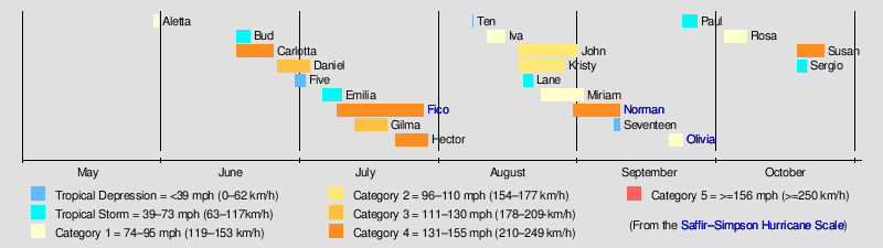
1978 Pacific hurricane season
| |
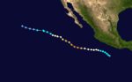
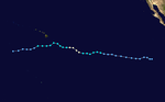
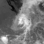
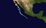
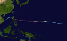
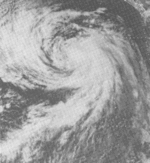
| Season summary map |
| First system formed |
May 30, 1978 |
| Last system dissipated |
October 21, 1978 |
| Strongest storm1 |
Fico, Hector, and Norman – 140 mph (220 km/h) (1-minute sustained) |
| Total depressions |
23 official, 2 unofficial |
| Total storms |
19 |
| Hurricanes |
14 |
| Major hurricanes (Cat. 3+) |
7 |
| Total fatalities |
Unknown |
| Total damage |
Unknown |
| 1Strongest storm is determined by lowest pressure |
Pacific hurricane seasons
1976, 1977, 1978, 1979, 1980 |
The 1978 Pacific hurricane season officially began May 15, 1978, in the eastern Pacific, June 1, 1978 in the central Pacific, and officially ended 30 November 1978. These dates conventionally delimit the period of time when tropical cyclones form in the eastern north Pacific Ocean.
Activity this year was slightly above average, with eighteen named storms forming. Five of those were tropical storms, thirteen were hurricanes, and six were major hurricanes that reached Category 3 or higher on the Saffir-Simpson Hurricane Scale. In the Central Pacific, a tropical depression and a major hurricane formed. Also, this season is the fourth most active season within the basin when counting on ACE Index, as the season had an index of 207. Atlantic Hurricane Greta crossed into the basin and was renamed Olivia.
Storms
Hurricane Aletta
| Category 1 hurricane (SSHWS) |
|
|
| Duration |
May 30 – May 31 |
| Peak intensity |
75 mph (120 km/h) (1-min) |
A small tropical disturbance formed in the Gulf of Tehuantepec on May 27. It quickly accelerated southwest, before turning north late the following day. At this time, thunderstorm activity increased in coverage, aided by an outflow channel to the Intertropical Convergence Zone (ITCZ) the disturbance. Early on May 3, the disturbance's center become better defined, resulting in an upgraded into a tropical storm by 1200 UTC. After curving northwest, Aletta rapidly intensified, and at 0000 UTC on May 31, Aletta was declared a minimal hurricane. However, hours later, Aletta degenerated into a tropical storm. On the afternoon of May 31, Aletta turned north-northwest due to a trough over northwestern Mexico and a ridge over southern Mexico. At 1730 UTC, Aletta moved ashore just west-northwest of Zihuatanejo. After moving inland, Aletta rapidly dissipated.[1]
Tropical Storm Bud
| Tropical storm (SSHWS) |
|
|
| Duration |
June 17 – June 20 |
| Peak intensity |
60 mph (95 km/h) (1-min) |
A tropical disturbance developed on June 15 around 800 mi (1,285 km) west-southwest of Acapulco. After moving west-southwest, the disturbance became more defined until June 17, when it was upgraded into a tropical depression. At noon, te depression was elevated to Tropical Storm Bud. Late on June 18, Bud reached its peak intensity of 60 mph (95 km/h), only to start weakening the following day as it moved west-northwest over cooler water. Early on June 20, Bud weakened to a tropical depression. Shortly thereafter, Bud ceased to exist as a tropical cyclone.[1]
Hurricane Carlotta
| Category 4 hurricane (SSHWS) |
|
|
| Duration |
June 17 – June 25 |
| Peak intensity |
130 mph (215 km/h) (1-min) |
Around the time Bud was developing, another tropical disturbance was developed 800 mi (1,285 km) to the east of Bud, but around 250 mi (400 km) west of Acapulco. Veering west-northwest, the small disturbance slowly organized and was designated as a tropical depression at 0600 UTC June 17. Eighteen hours later, the depression strengthened into Tropical Storm Carlotta. Thereafter, the system turned west-southwest south of a subtropical ridge in Bud's footsteps. Several hours after the formation of an eye early on June 19, Carlotta intensified into a hurricane. After becoming a hurricane, Carlotta tracked west-northwest,[1] and rapidly intensified. At 0000 UTC June 20, Hurricane Carlotta abruptly intensified into a major hurricane (Category 3 or higher on the Saffir-Simpson Hurricane Wind Scale).[2] Around 36 hours later, Carlotta peaked as a low-end Category 4 hurricane on the Saffir-Simpson Hurricane Wind Scale. On June 22, Carlotta started a gradual weakening trend as it turned northwest over cooler waters on June 22. Two days later, Carlotta weakened to a tropical storm. on 0600 UTC June 25, Carlotta degenerated into a tropical depression. Twelve hours later, Carlotta dissipated.[1]
Hurricane Daniel
| Category 3 hurricane (SSHWS) |
|
|
| Duration |
June 26 – July 3 |
| Peak intensity |
115 mph (185 km/h) (1-min) |
The fourth tropical disturbance of the season developed on June 24 roughly 200 mi (320 km) southwest of Nicaragua. Tracking west-northwest, the disturbance was upgraded into a tropical depression on June 26. The next day, the depression became a tropical storm, before weakening back to a tropical depression late on June 27. At 1500 UTC June 28, Daniel regained tropical storm intensity. While accelerating westward, Daniel intensified into a hurricane late on June 29. Midday on June 30, Daniel suddenly intensified into a major hurricane, peaking with winds of 115 mph (185 km/h). After maintaining its intensity for 24 hours, Daniel slowly began to weaken. Late on July 2, Daniel was downgraded into a tropical storm. By midday on July 3, Daniel fell to a tropical depression. Several hours later, the EPHC stopped tracking the cyclone.[1]
Tropical Depression Five
| Tropical depression (SSHWS) |
|
|
| Duration |
June 30 – July 2 |
| Peak intensity |
30 mph (45 km/h) (1-min) |
This storm began as a weak tropical disturbance on June 28.
Tropical Storm Emilia
| Tropical storm (SSHWS) |
|
|
| Duration |
July 6 – July 10 |
| Peak intensity |
65 mph (100 km/h) (1-min) |
A tropical disturbance developed just to the east of Acapulco on July 3. The disturbance then turned west, moving at 16kt began to intensify over 85.F water. With satellite imagery showing a cyclonic circulation about in the center, the disturbance was upgraded to a tropical depression on July 6 about 750 n mi west of Acapulco. The depression intensified into a tropical storm and was named Emilia. Emilia then turned to the north-west and continued to intensify. Winds near the center of the storm increased to 60 mph (95 km/h) by July 8 and reached their peak intensity of 65 mph (100 km/h) by July 9. As Emilia continued to move north-west, the cargo ship Marcona Exporter was helpful in locating the center of the storm. By July 10, Emilia was downgraded to a tropical depression with 35 mph (55 km/h) winds. Emilia was then over cooler water and rapidly dissipated.[1]
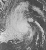
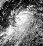
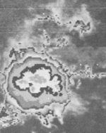
Hurricane Fico
| Category 4 hurricane (SSHWS) |
|
|
| Duration |
July 9 – July 28 |
| Peak intensity |
140 mph (220 km/h) (1-min) ≤ 955 mbar (hPa) |
Hurricane Fico was the longest-lived hurricane of the season and at the time was the longest-lasting Pacific hurricane on record. It developed from a tropical disturbance off the coast of Mexico on July 9. It moved northwestward and then westward, quickly reaching peak winds of 140 mph (220 km/h) on July 12. Moving nearly due westward, the intensity of Fico fluctuated from Category 1 to Category 4 status on the Saffir-Simpson Hurricane Scale for the following days, and it passed about 170 miles (275 km) south of Hawaii on July 20 with winds of 115 mph (185 km/h). Fico slowly weakened as it turned to the northwest over cooler waters, and became an extratropical cyclone on July 28 to the northeast of Midway Island.
Swells from Fico, combined with swells from a storm in the Southern Hemisphere, produced rough surf throughout the Hawaiian islands. The surf destroyed one house and resulted in considerable damage along the southern coast of the island of Hawaii. No deaths were reported, and damage totaled $200,000 (1978 USD, $619,000 2006 USD).[3]
Hurricane Gilma
| Category 3 hurricane (SSHWS) |
|
|
| Duration |
July 13 – July 20 |
| Peak intensity |
115 mph (185 km/h) (1-min) |
Gilma was a short-lived storm which did not affect land.
Hurricane Hector
| Category 4 hurricane (SSHWS) |
|
|
| Duration |
July 22 – July 29 |
| Peak intensity |
140 mph (220 km/h) (1-min) |
Hector was the strongest storm of this year, but did not affect land.
Tropical Depression Ten
| Tropical depression (SSHWS) |
|
|
| Duration |
August 6 – August 9 |
| Peak intensity |
35 mph (55 km/h) (1-min) |
Existed on August 8.
Hurricane Iva
| Category 1 hurricane (SSHWS) |
|
|
| Duration |
August 11 – August 15 |
| Peak intensity |
75 mph (120 km/h) (1-min) |
Iva's scattered remnants caused rain on the islands of Hawaii and Maui.
Hurricane John
| Category 2 hurricane (SSHWS) |
|
|
| Duration |
August 18 – August 31 |
| Peak intensity |
105 mph (165 km/h) (1-min) |
John was a category 2 storm that did not affect land.
Hurricane Kristy
| Category 2 hurricane (SSHWS) |
|
|
| Duration |
August 18 – August 28 |
| Peak intensity |
105 mph (165 km/h) (1-min) |
Kristy was a category 2 storm that did not affect land.
Tropical Storm Lane
| Tropical storm (SSHWS) |
|
|
| Duration |
August 19 – August 24 |
| Peak intensity |
50 mph (85 km/h) (1-min) |
Lane was a storm that did not affect land.
Hurricane Miriam
| Category 1 hurricane (SSHWS) |
|
|
| Duration |
August 23 – September 2 |
| Peak intensity |
90 mph (150 km/h) (1-min) |
Miriam threatened the Hawaiian Islands as a tropical storm, but veered south. Miriam had no effect on the islands. The storm dissipated September 2.
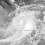
Hurricane Norman
| Category 4 hurricane (SSHWS) |
|
|
| Duration |
August 30 – September 7 |
| Peak intensity |
140 mph (220 km/h) (1-min) |
Norman was powerful Category 4 hurricane. It had no effect on land as a hurricane, but after weakening to a tropical storm, Norman recurved and headed straight for southern California. Norman made landfall as a depression and had dissipated by September 7. Heavy rains fell across the Sierra Nevada range in California, with a maximum amount of 7.01 inches reported at Lodgepole.[4]
Tropical Depression Seventeen
| Tropical depression (SSHWS) |
|
|
| Duration |
September 8 – September 9 |
| Peak intensity |
30 mph (45 km/h) (1-min) |
Existed between September 8 and September 9.
Hurricane Olivia
| Category 1 hurricane (SSHWS) |
|
|
| Duration |
September 20 – September 23 |
| Peak intensity |
75 mph (120 km/h) (1-min) |
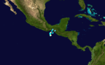
Hurricane Olivia was a continuation of Atlantic Hurricane Greta. The depression emerged from Central America and quickly restrengthened into Tropical Storm Olivia. The storm erratically changed course and headed straight north as a hurricane. Olivia made landfall near the Isthmus of Tehuantepec and dissipated on September 23.
Tropical Storm Paul
| Tropical storm (SSHWS) |
|
|
| Duration |
September 23 – September 27 |
| Peak intensity |
45 mph (75 km/h) (1-min) |
Paul brushed the southern tip of Baja California and made landfall in western Mexico.
Hurricane Rosa
| Category 1 hurricane (SSHWS) |
|
|
| Duration |
October 2 – October 7 |
| Peak intensity |
85 mph (140 km/h) (1-min) |
As a tropical storm, Rosa came close to Baja California Sur but never made landfall.
Hurricane Susan
| Category 4 hurricane (SSHWS) |
|
|
| Duration |
October 18 – October 24 |
| Peak intensity |
130 mph (215 km/h) (1-min) 954 mbar (hPa) |
The only cyclone to develop in the central Pacific did so on October 18. Susan rapidly intensified into a Category 4 hurricane and one of the three strongest storms then known in the central Pacific. Initially heading on a course that aimed directly at the Big Island, Susan instead turned to the southwest and decayed rapidly due to wind shear.
Tropical Storm Sergio
| Tropical storm (SSHWS) |
|
|
| Duration |
October 18 – October 21 |
| Peak intensity |
40 mph (65 km/h) (1-min) |
Sergio dissipated before making landfall on the Pacific coast of Baja California.
Other storms
Tropical Depression 10A
| Tropical depression (SSHWS) |
|
|
| Duration |
August 7 – August 9 |
| Peak intensity |
35 mph (55 km/h) (1-min) |
Existed in the Central Pacific. This system was labeled Tropical Depression 10-A by the Joint Typhoon Warning Center.
Tropical Depression Rita
| Tropical depression (SSHWS) |
|
|
| Duration |
October 15 – October 16 (Exited basin) |
| Peak intensity |
25 mph (35 km/h) (1-min) |
According to the Joint Typhoon Warning Center, on October 15 a tropical depression formed east of the International Dateline, and soon exited CPHC's area of responsibility;[5] however, this storm wasn't included into CPHC database. As it entered into western Pacific, it strengthened as a tropical storm and received the name Rita.[5]
Storm names
These names were used for storms forming in the eastern Pacific Ocean this year. This is the first time most of these names were used, except for Aletta, Carlotta, Iva and Olivia, which were previously used in the old four-year lists. Names not retired from this list were used in the 1982 season. At this time, lists were intended to be repeated every four years instead of six.
This is the first season to use lists with male and female names on it. It is also the first year of modern naming.
- Aletta
- Bud
- Carlotta
- Daniel
- Emilia
- Fico
- Gilma
|
- Hector
- Iva
- John
- Kristy
- Lane
- Miriam
- Norman
|
- Olivia
- Paul
- Rosa
- Sergio
- Tara (unused)
- Vicente (unused)
- Willa (unused)
|
The central Pacific used names and numbers from the western Pacific's typhoon list. One name – Susan – was used.
Retirement
The World Meteorological Organization retired the name Fico in the spring of 1979. It was replaced with Fabio.
See also
References
External links
|
|---|
|
| |
|
-
 Book Book
-
 Category Category
-
 Portal Portal
-
 WikiProject WikiProject
-
 Commons Commons
|


-_072078.JPG)