1893 Atlantic hurricane season
| |
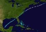
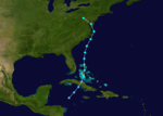
| Season summary map |
| First system formed |
June 12, 1893 |
| Last system dissipated |
November 9, 1893 |
| Strongest storm1 |
"Cheniere Caminada" – 948 mbar (hPa) (27.99 inHg), 135 mph (215 km/h) |
| Total depressions |
12 |
| Total storms |
12 |
| Hurricanes |
10 |
| Major hurricanes (Cat. 3+) |
5 |
| Total fatalities |
~4,028 |
| Total damage |
At least $6 million (1893 USD) |
| 1Strongest storm is determined by lowest pressure |
Atlantic hurricane seasons
1891, 1892, 1893, 1894, 1895 |
The 1893 Atlantic hurricane season ran through the summer and the first half of fall in 1893. The 1893 season was fairly active, with 12 tropical storms forming, 10 of which became hurricanes. Of those, 5 became major hurricanes. This season proved to be a very deadly season, with two different hurricanes each causing over two thousand (2000) deaths in the United States; at the time, the season was the deadliest in U.S. history. The season was one of two on the record, along with the 1998 Atlantic hurricane season, when 4 Atlantic hurricanes were active on the same day.
Storms
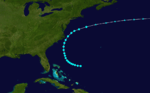
Hurricane One
| Category 1 hurricane (SSHWS) |
|
|
| Duration |
June 12 – June 19 |
| Peak intensity |
75 mph (120 km/h) (1-min) 1002 mbar (hPa) |
The season began early with its 1st storm forming on June 12 in the Bay of Campeche. The storm moved northeastward throughout its life, and hit the Florida Panhandle on June 16 as a strong tropical storm. After weakening over the Southeastern United States, the storm emerged over the Atlantic Ocean near Norfolk, Virginia. After briefly strengthening to a hurricane, the storm succumbed to cold water and shear and became extratropical on June 20.
Hurricane Two
| Category 2 hurricane (SSHWS) |
|
|
| Duration |
July 4 – July 7 |
| Peak intensity |
100 mph (155 km/h) (1-min) |
July continued the season's activity, with a tropical storm forming in the western Caribbean Sea north of Panama on July 4. The 2nd storm of the season intensified to a 95 mph (153 km/h) hurricane before hitting the northeast coast of Honduras. It mainly retained its strength until it hit the northeastern coast of Belize on July 6. Afterwards, it rapidly weakened over the Yucatán Peninsula and dissipated on July 7. The storm sank several ships and reportedly caused a large loss of life. It has been paleotempestologically traced in sediment near Gales Point.[1]
Hurricane Three
| Category 3 hurricane (SSHWS) |
|
|
| Duration |
August 13 – August 22 |
| Peak intensity |
120 mph (195 km/h) (1-min) 986 mbar (hPa) |
The 3rd storm of the season, known as the San Roque Hurricane, formed on August 13 east of the Lesser Antilles. It steadily strengthened to a hurricane while moving over the Leeward Islands. While approaching Puerto Rico on August 16, its winds increased to major hurricane status before landfall at Patillas. It crossed the island and exited near Isabela.[2] There were heavy rains over the island of Puerto Rico and damages to the agricultural crops, especially coffee. In San Juan 2.36 inches of rain were reported.[2] The eye remained over Puerto Rico for a period of seven hours. The lowest barometric pressure reading recorded in San Juan was 29.17 inches. Four deaths were reported. This was the first hurricane in Puerto Rico where flags were used to alert the public about the danger of an approaching hurricane; they were flown from government buildings.[2][3]
Although landfall weakened the storm, the storm regained major hurricane status as it approached the Bahamas. It then re curved northward and hit Halifax, Nova Scotia as a non-tropical category 1. This hurricane was one of four active hurricanes on August 22.
Hurricane Four
| Category 3 hurricane (SSHWS) |
|
|
| Duration |
August 15 – August 24 |
| Peak intensity |
115 mph (185 km/h) (1-min) 952 mbar (hPa) |
The 4th storm of the season began its life in the Central Tropical Atlantic on August 15. The storm moved west-northwestward for the first week of its life, while strengthening on the way. As it reached Category 3 strength, it moved more northwestward. Cooler waters weakened the storm, but it managed to hit New York City directly as an 85 mph (137 km/h) hurricane. It was one of only two hurricanes to directly hit New York throughout the 19th century, with the other being the 1821 Norfolk and Long Island hurricane. This storm was one of four active hurricanes on August 22.
Hurricane Five
| Category 2 hurricane (SSHWS) |
|
|
| Duration |
August 15 – August 19 |
| Peak intensity |
100 mph (155 km/h) (1-min) |
The 5th storm of the season started east of Bermuda on August 15. After moving northwestward for a day, it moved northeastward and strengthened to a Category 2 hurricane. The storm hit the Burin Peninsula of Newfoundland on August 18 as a 90 mph (145 km/h) hurricane, and dissipated the day after.
Hurricane Six
| Category 3 hurricane (SSHWS) |
|
|
| Duration |
August 15 – August 30 |
| Peak intensity |
120 mph (195 km/h) (1-min) 954 mbar (hPa) |
The 6th storm of the season, known as the 1893 Sea Islands Hurricane, formed near Cape Verde on August 15. The storm moved generally westward for the first 11 days of its life, during which it strengthened to a Category 3 hurricane. As it approached the Bahamas, it moved more northwestward, paralleling the coast of Florida. The storm hit near Savannah, Georgia and was responsible for the deaths of 2000 people. It moved northeastward, and underwent extratropical transition on August 31. This hurricane was one of four active hurricanes on August 22.
Hurricane Seven
| Category 2 hurricane (SSHWS) |
|
|
| Duration |
August 20 – August 29 |
| Peak intensity |
100 mph (155 km/h) (1-min) |
The 7th storm of the season formed near the Cape Verde islands on August 20. It moved northwestward, reaching Category 2 hurricane strength on August 23. The hurricane maintained its strength until August 28, when cooler waters led the storm to extratropical transition. This storm was one of four active hurricanes on August 22. This hurricane could be one of the strongest tropical cyclones to have passed the Azores in the previous 100 years. It caused significant casualties and damages at Faial and Terceira islands that were documented afterwards (M. Lima, and J. Agostinho).
Hurricane Eight
| Category 2 hurricane (SSHWS) |
|
|
| Duration |
September 4 – September 9 |
| Peak intensity |
100 mph (155 km/h) (1-min) 973 mbar (hPa) |
The 8th storm of the season formed in the western Caribbean Sea on September 4. After hitting the Yucatán Peninsula, it strengthened in the Gulf of Mexico to a 95 mph (153 km/h) hurricane. It hit the southern coast of Louisiana on September 7, and dissipated over northeastern Alabama.
Hurricane Nine
| Category 3 hurricane (SSHWS) |
|
|
| Duration |
September 25 – October 14 |
| Peak intensity |
120 mph (195 km/h) (1-min) 955 mbar (hPa) |
The 9th storm of the season was known as the Charleston Hurricane. It formed southwest of Cape Verde on September 25. It moved westward for the first 8 days of its life then it moved more northwestward. During this time it strengthened to a major hurricane, and it maintained its strength until landfall. As it bypassed the Bahamas, it moved more northward, and struck near Myrtle Beach, South Carolina on October 13 with winds around 120 mph (190 km/h). It moved through North Carolina and the Appalachian Mountains, becoming extratropical on October 14. It caused 28 deaths.
The hurricane had an estimated Accumulated Cyclone Energy of 63.5, one of the highest of any historical Atlantic hurricane.
Hurricane Ten
| Category 4 hurricane (SSHWS) |
|
|
| Duration |
September 27 – October 5 |
| Peak intensity |
135 mph (215 km/h) (1-min) 948 mbar (hPa) |
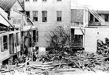
The 10th storm of the season, known as the Cheniere Caminada hurricane, began on September 27 in the western Caribbean Sea. After hitting the northeastern coast of the Yucatán Peninsula as a Category 2 hurricane, it moved through the Gulf of Mexico. As it approached the southeast coast of Louisiana, it rapidly strengthened to a Category 4 hurricane, and hit land on October 2. It moved through Alabama, Georgia, and the Carolinas before dissipating at sea. This storm was one of the first hurricanes to officially receive a Category 4 designation on the modern Saffir-Simpson scale. It killed 2,000 people and caused around $5 million (1893 dollars) in damage.
Tropical Storm Eleven
| Tropical storm (SSHWS) |
|
|
| Duration |
October 20 – October 23 |
| Peak intensity |
60 mph (95 km/h) (1-min) |
The 11th storm of the season formed just south of the Isla de la Juventud on October 20. After moving through Cuba, it strengthened to a 60 mph (97 km/h) storm before it hit the Delmarva Peninsula on October 23.
Tropical Storm Twelve
| Tropical storm (SSHWS) |
|
|
| Duration |
November 5 – November 9 |
| Peak intensity |
70 mph (110 km/h) (1-min) |
The 12th and final storm of the season formed northeast of the Bahamas on November 5. The storm moved northwestward, almost hitting North Carolina as a strong tropical storm, but went out to sea, becoming extratropical on November 10.
See also
References
External links
Most intense Atlantic hurricane seasons |
|---|
|
|
|
|
|
Note: There is an undercount bias of zero to six tropical cyclones per year between 1851 and 1885 and zero to four per year between 1886 and 1910, due to the lack of modern observation techniques, see Tropical cyclone observation. |