111th Street (IRT Flushing Line)
| 111th Street | |||||||
|---|---|---|---|---|---|---|---|
| New York City Subway rapid transit station | |||||||
|
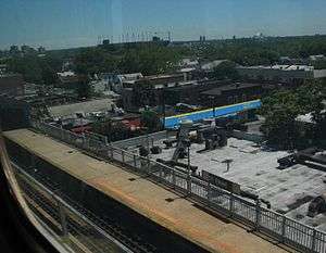
A view of the platform as seen from an express train on the flyover track. | |||||||
| Station statistics | |||||||
| Address |
111th Street & Roosevelt Avenue Queens, NY 11368 | ||||||
| Borough | Queens | ||||||
| Locale | Corona | ||||||
| Coordinates | 40°45′6.17″N 73°51′20.29″W / 40.7517139°N 73.8556361°WCoordinates: 40°45′6.17″N 73°51′20.29″W / 40.7517139°N 73.8556361°W | ||||||
| Division | A (IRT) | ||||||
| Line | IRT Flushing Line | ||||||
| Services |
7 | ||||||
| Transit connections |
| ||||||
| Structure | Elevated | ||||||
| Platforms | 2 side platforms | ||||||
| Tracks | 5 (2 local in passenger service at platform level; 1 express track above) | ||||||
| Other information | |||||||
| Opened | October 13, 1925 | ||||||
| Traffic | |||||||
| Passengers (2015) |
3,699,843[1] | ||||||
| Rank | 140 out of 422 | ||||||
| Station succession | |||||||
| Next north |
Mets–Willets Point: 7 | ||||||
| Next south |
103rd Street–Corona Plaza: 7 | ||||||
| |||||||
| |||||||


111th Street is a local station on the IRT Flushing Line of the New York City Subway, located at the intersection of 111th Street and Roosevelt Avenue.[2] It is served by the 7 train at all times.[3]
History

The station was opened on October 13, 1925, with shuttle service between 111th Street and the previous terminal at Alburtis Avenue (now 103rd Street–Corona Plaza).[4] The line was extended to Willets Point Boulevard (now Mets–Willets Point) on May 7, 1927,[5] and to the current terminal at Flushing–Main Street on January 21, 1928.[6]
The platforms at 111th Street were extended in 1955–1956 to accommodate 11-car trains.[7]
Station layout
| L3 Express track |
Peak-direction express | ← |
| L2 Platform level |
Side platform, doors will open on the right | |
| Southbound local | ← | |
| Yard lead | → No regular service | |
| Yard lead | → No regular service | |
| Northbound local | → → | |
| Side platform, doors will open on the right | ||
| M | Mezzanine | to entrances/exits, station agent, MetroCard vending machines |
| G | Street Level | Entrances/Exits |
The station has five tracks and two side platforms. The express track is located on a flyover above the other four tracks. The two center tracks are not used in passenger service, but instead are used as yard leads of the Corona Yard, where 7 trains are maintained and stored. As a result, trains that go to/from the yard often terminate or begin at this station.[8][9][10] Stations with flyover express tracks such as this were far more common on IRT elevated lines in Manhattan during the 19th and early 20th centuries. Due to the yard tracks, an unusual layout takes place in and north of the station. The two layup tracks only have connections to the main tracks north of the station. The northbound track rises north of the station while the express track lowers. The layup tracks dive down and cross under the northbound track. The southbound track then rises to level out the three tracks, which continue north.[11]
This station has full windscreens except at the south end of the northbound platform, which has a waist-high steel fence instead. Exit is at the south (geographic west) end, with staircases to all four corners of 111th Street and Roosevelt Avenue.[9][12] The mezzanine and stairway landings are wooden while the flooring at the fare control area is concrete.[13] The station has a crossunder between platforms. New signs have covered the old ones. Above some of the black station signs reading "111 Street" are white signs reading "Hall of Science", identifying the nearby New York Hall of Science five blocks south.[9][12][14][15]
References
- ↑ "Facts and Figures: Annual Subway Ridership". Metropolitan Transportation Authority. Retrieved 2016-04-19.
- ↑ "MTA Neighborhood Maps: Corona" (PDF). Metropolitan Transportation Authority. 2015. Retrieved 20 September 2015.
- ↑ "7 Subway Timetable, Effective November 7, 2016" (PDF). New York Metropolitan Transportation Authority. Retrieved November 7, 2016.
- ↑ "First Trains to be Run on Flushing Tube Line Oct. 13: Shuttle Operation Ordered to 111th Street Station on New Extension". Newspapers.com. Brooklyn Daily Eagle. October 5, 1925. p. 8. Retrieved 20 September 2015.
- ↑ "CORONA SUBWAY EXTENDED; New Service Goes to Within 350 Feet of Flushing Creek Bridge". The New York Times. May 8, 1927. p. 26. Retrieved September 26, 2009.
- ↑ "FLUSHING REJOICES AS SUBWAY OPENS; Service by B.M.T. and I.R.T. Begins as Soon as Official Train Makes First Run. HOPE OF 25 YEARS REALIZED Pageant of Transportation Led by Indian and His Pony Marks the Celebration. Hedley Talks of Fare Rise. Transit Modes Depicted.". The New York Times. January 22, 1928. Retrieved 18 September 2015.
- ↑ Authority, New York City Transit (1955-01-01). Minutes and Proceedings.
- ↑ Marrero, Robert (2015-09-13). "469 Stations, 846 Miles" (PDF). B24 Blog, via Dropbox. Retrieved 2015-10-09.
- 1 2 3 Cox, Jeremiah. "111 Street (7) - The SubwayNut". www.subwaynut.com. Retrieved 2016-02-18.
- ↑ "www.nycsubway.org: IRT Flushing Line". www.nycsubway.org. Retrieved 2016-02-18.
- ↑ Marrero, Robert (2015-09-13). "469 Stations, 846 Miles" (PDF). B24 Blog, via Dropbox. Retrieved 2015-10-09.
- 1 2 "MTA Neighborhood Maps: Corona" (PDF). Metropolitan Transportation Authority. 2015. Retrieved 20 September 2015.
- ↑ "7 Train". 2014-08-11. Archived from the original on August 11, 2014. Retrieved 2016-02-18.
- ↑ Associated Press (April 10, 2014). "Revisiting NYC's 1964 World's Fair, 50 Years Later". New York City: The New York Times. Retrieved 20 September 2015.
- ↑ Browne, Malcolm W. (September 5, 1986). "CITY AGAIN BOASTS A SCIENCE MUSEUM". The New York Times. Retrieved 20 September 2015.
External links
| Wikimedia Commons has media related to 111th Street (IRT Flushing Line). |