Flushing–Main Street (IRT Flushing Line)
| Flushing–Main Street | |||||||||
|---|---|---|---|---|---|---|---|---|---|
| New York City Subway rapid transit station | |||||||||
|
Center track | |||||||||
| Station statistics | |||||||||
| Address |
Main Street and Roosevelt Avenue Queens, NY 11354 | ||||||||
| Borough | Queens | ||||||||
| Locale | Flushing | ||||||||
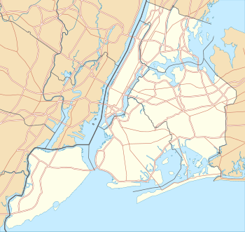
| Coordinates | 40°45′34.28″N 73°49′49.14″W / 40.7595222°N 73.8303167°WCoordinates: 40°45′34.28″N 73°49′49.14″W / 40.7595222°N 73.8303167°W | ||||||||
| Division | A (IRT) | ||||||||
| Line | IRT Flushing Line | ||||||||
| Services |
7 | ||||||||
| Transit connections |
| ||||||||
| Structure | Underground | ||||||||
| Platforms | 2 island platforms | ||||||||
| Tracks | 3 | ||||||||
| Other information | |||||||||
| Opened | January 21, 1928[1] | ||||||||
| Accessible |
| ||||||||
| Wireless service |
| ||||||||
| Traffic | |||||||||
| Passengers (2015) |
19,082,391[3] | ||||||||
| Rank | 12 out of 422 | ||||||||
| Station succession | |||||||||
| Next north |
(Terminal): 7 | ||||||||
| Next south |
Mets–Willets Point: 7 | ||||||||
|
| |||||||||
| Next |
none: 7 | ||||||||
| Next |
Junction Boulevard: 7 | ||||||||
| |||||||||
| |||||||||
|
| |||||||||
|
Main Street Subway Station (Dual System IRT) | |||||||||
| MPS | New York City Subway System MPS | ||||||||
| NRHP Reference # | 04001147[4] | ||||||||
| Added to NRHP | October 14, 2004 | ||||||||


Flushing–Main Street (signed as Main Street on entrances and pillars, and Main St–Flushing on overhead signs) is the northern terminal station on the IRT Flushing Line of the New York City Subway, located at Main Street and Roosevelt Avenue in the Downtown section of Flushing, Queens.[5] It is served by the 7 at all times and the <7> train rush hours in the peak direction.[6]
The Flushing–Main Street station was originally built as part of the Dual Contracts between the Interborough Rapid Transit Company (IRT) and the Brooklyn–Manhattan Transit Corporation (BMT). It opened on January 21, 1928, completing the segment of the Flushing Line in Queens. Although plans existed for the line to be extended east of the station, such an extension was never built. The station was renovated in the 1990s.
The passenger count in 2015 for the station was 19,082,391, making it the 12th busiest station system-wide, the busiest station in Queens, and the busiest station outside of Manhattan.[3][7]
History

The station was constructed under the Dual Contracts as part of an extension of the Flushing Line past 103rd Street–Corona Plaza.[8][9] At the time of the line's planning in the 1910s, Downtown Flushing was a quiet Dutch-colonial-style village; what is now Roosevelt Avenue in the area was known as Amity Street, a major commercial thoroughfare in the neighborhood.[9][10] It was decided to build the station underground due to local opposition to the disturbances, loss of property value, and the required widening of Amity Street that an elevated line would bring.[10] Thus, it is one of only seven underground stations on the Flushing Line,[lower-alpha 1] one of three underground stations on the line in Queens,[lower-alpha 2] and the only underground station east of Queensboro Plaza.[11] Construction of the station and the double-deck bridge over the Flushing Creek began on April 21, 1923, with the station built via cut-and-cover methods.[10] The bridge was completed in 1927, and the station opened on January 21, 1928, over a decade after the line began operation.[1][10][12]
Following the station's opening, Downtown Flushing evolved into a major commercial and transit center, as development sprung around the section of Main Street near the station.[10][13] On April 24, 1939, express trains began operating to and from the station, in conjunction with the reconstruction of the Willets Point station for the 1939 World's Fair.[14][15] Due to the high level of passenger use, beginning in 1940 local residents requested an additional exit at the east end of the station, and the widening of existing staircases.[16][17][18][19] A new eastern entrance was added after World War II.[10][20] Ground broke on the new entrance on November 5, 1947,[21][22] and it opened on October 28, 1948 with two new street stairs and an additional token booth.[23][22][24] Upon its initial opening, the new entrance did little to relieve crowding at the main fare control area.[23][22]
The platforms at Main Street and all other stations on the Flushing Line with the exception of Queensboro Plaza were extended in 1955–1956 to accommodate 11-car trains.[25]
A station renovation had been planned since the 1970s. In 1981, the MTA listed the station among the 69 most deteriorated stations in the subway system.[26] The MTA finally found funding for the station's renovation in 1994—at the expense of the renovations of 15 other stations, including three Franklin Avenue Line stations and the Atlantic Avenue–Pacific Street, Roosevelt Avenue/74th Street, and 161st Street–Yankee Stadium station complexes—because the station was a "vital station" for commuters from Eastern Queens.[27] Between 1999 and 2000, the station underwent a major renovation project. The renovation added an elevator near the eastern Lippmann Plaza exit that made the station compliant with the Americans with Disabilities Act of 1990. The project also added new street entrances and a large entrance hall near Lippmann Plaza at the far east end of the station, beyond the bumper blocks at the end of the tracks.[12][7][28][29] Prior to 1999, the tracks went past where the current bumper blocks are, to a dead-end, as the line was planned to extend eastward.[30]
The Flushing–Main Street station has been listed on the National Register of Historic Places since 2004.[31]
Proposed extension of the line
Under several expansion plans of the New York City Subway, including the Dual Contracts and the IND Second System, the Flushing Line would have been extended past Main Street, along and/or parallel to the right-of-way of the nearby Port Washington Branch of the Long Island Rail Road towards Bell Boulevard in Bayside. A spur line would have branched off north along 149th Street towards College Point.[8][10][32][33][34][35]
Station layout
| G | Street level | Entrances/exits to Main Street | |
| M | Concourse | Lobby, MetroCard vending machines, station agent | |
| P Platforms |
Track 1 | ← |
Lippmann Plaza entrance Lobby, MetroCard vending machines, escalator to Roosevelt Avenue |
| Island platform, doors will open on the left, right | |||
| Track M | ← | ||
| Island platform, doors will open on the left, right | |||
| Track 2 | ← | ||
Track layout | |||||||||||||||||||||||||||||||||||||||||||||||||||||||||||||||||||||||||||||||||||||||||||||||||||||||||||||||||||||||||||||||||||||||||||||||||||
|---|---|---|---|---|---|---|---|---|---|---|---|---|---|---|---|---|---|---|---|---|---|---|---|---|---|---|---|---|---|---|---|---|---|---|---|---|---|---|---|---|---|---|---|---|---|---|---|---|---|---|---|---|---|---|---|---|---|---|---|---|---|---|---|---|---|---|---|---|---|---|---|---|---|---|---|---|---|---|---|---|---|---|---|---|---|---|---|---|---|---|---|---|---|---|---|---|---|---|---|---|---|---|---|---|---|---|---|---|---|---|---|---|---|---|---|---|---|---|---|---|---|---|---|---|---|---|---|---|---|---|---|---|---|---|---|---|---|---|---|---|---|---|---|---|---|---|---|
Legend | |||||||||||||||||||||||||||||||||||||||||||||||||||||||||||||||||||||||||||||||||||||||||||||||||||||||||||||||||||||||||||||||||||||||||||||||||||
| |||||||||||||||||||||||||||||||||||||||||||||||||||||||||||||||||||||||||||||||||||||||||||||||||||||||||||||||||||||||||||||||||||||||||||||||||||
The station has three tracks and two relatively narrow island platforms, due to Roosevelt Avenue's narrow width of approximately 50 feet (15 m).[10][7] When peak-direction express service operates, express trains will leave from the middle and southernmost tracks, Track M and Track 2 respectively, while local trains will leave from Track 1. This system was instituted in November 1952.[36] Mosaic on the wall tiles read "MAIN STREET"; small tiles along the platforms read "M".
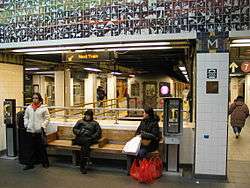
There are nine entrances at street level, leading to two separate fare control areas.[7][5] The original street exit is in the middle of the platforms with a separate fare control mezzanine above the tracks, and the 24-hour station agent's booth.[17][19][37] Staircases lead up to all four corners of Main Street and Roosevelt Avenue.[7][5][17][19] The new fare control area at Lippmann Plaza has an extremely high ceiling, with the lobby itself located approximately 40 feet (12 m) below the street level. The mezzanine is at platform level, and provides an ADA-compliant elevator, three unidirectional escalators, and a stairway to street level at Lippmann Plaza.[12][7][5] New artwork titled Happy World was installed over the row of turnstiles in 1998.[12][7][38][39][40] The plaza, also known as Lippmann Arcade, is a pedestrian walkway that leads to a municipal parking lot and several bus stops on 39th Avenue.[7][5]
At the west end of the platforms are the offices and dispatch tower for the IRT Flushing Line. Train crews report to the offices, while the dispatch tower dispatches trains and controls the Flushing Line. West of the station, the line rises from the tunnel via a portal at College Point Boulevard, and onto the elevated bridge across Flushing Creek.[10]
Bus service
In addition to connecting with the nearby Long Island Rail Road station of the same name, the station serves as one of the two busiest local bus-subway interchanges in Queens (along with Jamaica Center) and the largest in North America,[10][7][29][5] with over 20 bus routes running through or terminating in the area as of 2015.[41][42]
| Route | Operator | Stop location | North/West Terminal | South/East Terminal | via | notes |
|---|---|---|---|---|---|---|
| Local Bus Routes | ||||||
| NYCT | Roosevelt Avenue (near Lippmann Plaza) | Little Neck | Sanford Avenue, Northern Boulevard | |||
| 39th Avenue (near Lippmann Plaza) | Fort Totten | Northern Boulevard, Bell Boulevard | ||||
| Roosevelt Avenue (near Lippmann Plaza) | Beechhurst | 41st Avenue, 150th Street | ||||
| 39th Avenue (near Lippmann Plaza) | Fort Totten | Bayside Avenue | ||||
| Main Street | Jamaica–Merrick Boulevard | Kissena Boulevard, Horace Harding Expressway, 188th Street, Hillside Avenue | Northern terminal shifted from Main Street and 39th Avenue to 39th Avenue and 138th Street in August 2014. | |||
| MTA Bus | Roosevelt Avenue (west of Main Street) | Astoria | 30th Avenue, 58th Street, Woodside Avenue, 65th Place, 69th Street | |||
| NYCT | Main Street | College Point | Jamaica–Merrick Boulevard | Archer Avenue, Main Street, 20th Avenue (Q20A), 14th Avenue (Q20B) | ||
| MTA Bus | College Point | Jamaica–LIRR Station | Parsons Boulevard, Kissena Boulevard, 127th Street | |||
| NYCT | Roosevelt Avenue (near Lippmann Plaza) | Auburndale | Parsons Boulevard, 46th Avenue, Hollis Court Boulevard | Rush-hours only | ||
| Main Street | Queens Village or Cambria Heights | Kissena Boulevard, 46th Avenue, 48th Avenue, Springfield Boulevard | Northern terminal shifted from Main Street and 39th Avenue to 39th Avenue and 138th Street in August 2014. | |||
| 39th Avenue (near Lippmann Plaza) | Bay Terrace Shopping Center | Northern Boulevard, Crocheron Avenue, 32nd Avenue, Corporal Kennedy Street | ||||
| MTA Bus | Main Street | Whitestone | Jamaica–LIRR Station | Parsons Boulevard, Kissena Boulevard, Union Street | ||
| NYCT | Bronx Zoo–West Farms Square | Jamaica–Merrick Boulevard | Archer Avenue, Main Street, Union Street, Parsons Boulevard, Cross Bronx Expressway | Converted into Q44 Select Bus Service on November 29, 2015. | ||
| Roosevelt Avenue (west of Main Street) | LaGuardia Airport | Roosevelt Avenue, 108th Street, Ditmars Boulevard | ||||
| MTA Bus | Co-op City, Bronx | Whitestone Expressway, Hutchinson River Parkway, Bruckner Boulevard, Co-op City Boulevard | Limited-stop Service | |||
| NYCT | 41st Road | Ridgewood Terminal | Fresh Pond Road, Grand Avenue, Corona Avenue, College Point Boulevard | |||
| MTA Bus | Main Street | College Point | Jamaica–LIRR Station | 164th Street, 45th Avenue, College Point Boulevard | ||
| Roosevelt Avenue (west of Main Street) | Long Island City–Queens Plaza | 21st Street, 35th Avenue, Northern Boulevard | ||||
| NICE Bus | Roosevelt Avenue (near Lippmann Plaza) | Hicksville LIRR Station | Broadway (Hicksville), Northern Boulevard | |||
| Glen Cove, Nassau County | Glen Avenue, Bryant Avenue, Northern Boulevard | |||||
Attractions and points of interest

The station is located in Downtown Flushing, also known as Flushing Chinatown, one of New York City's largest Asian enclaves.[43][44]
Nearby points of interest include:
- Flushing Town Hall, at Northern Boulevard and Linden Place.[5]
- St George's Church, on Main Street near Roosevelt Avenue.[5]
- Flushing Main Post Office, on Main Street between Sanford and Maple Avenues.[5]
- Queens Library Flushing, at Main Street and Kissena Boulevard, the successor to the original Queens Library branch.[5][44]
- Lippmann Plaza, between 39th Avenue and Roosevelt Avenue east of Main Street. Named after longtime Flushing businessman Paul Lippmann.[5][45]
Gallery
 Eastern entrance, refurbished in 1999
 Eastern entrance ticket hall
 A Q65 bus outside the station, at Main Street and Roosevelt Avenue
Notes
- ↑ The other six underground stations are 34th Street–Hudson Yards, Times Square, Fifth Avenue, Grand Central, Vernon Boulevard–Jackson Avenue, and Hunters Point Avenue.
- ↑ The other two underground stations in Queens are Vernon Boulevard–Jackson Avenue and Hunters Point Avenue.
References
- 1 2 "FLUSHING REJOICES AS SUBWAY OPENS; Service by B.M.T. and I.R.T. Begins as Soon as Official Train Makes First Run. HOPE OF 25 YEARS REALIZED Pageant of Transportation Led by Indian and His Pony Marks the Celebration. Hedley Talks of Fare Rise. Transit Modes Depicted.". The New York Times. January 22, 1928. Retrieved September 18, 2015.
- ↑ "NYC Subway Wireless – Active Stations". Transit Wireless Wifi. Retrieved 2016-05-18.
- 1 2 "Facts and Figures: Annual Subway Ridership". Metropolitan Transportation Authority. Retrieved April 19, 2016.
- ↑ "NPS Focus". National Register of Historic Places. National Park Service. Retrieved December 9, 2011.
- 1 2 3 4 5 6 7 8 9 10 11 "MTA Neighborhood Maps: Flushing" (PDF). mta.info. Metropolitan Transportation Authority. 2015. Retrieved July 5, 2015.
- ↑ "7 Subway Timetable, Effective November 7, 2016" (PDF). New York Metropolitan Transportation Authority. Retrieved November 7, 2016.
- 1 2 3 4 5 6 7 8 9 "Flushing Commons: Chapter 15: Transit and Pedestrians" (PDF). nyc.gov. June 9, 2010. Retrieved September 18, 2015.
- 1 2 "FLUSHING LINE RISK PUT ON THE CITY; Interborough Agrees to Equip and Operate Main St. Branch, but Won't Face a Loss. IT MAY BE A PRECEDENT Company's Letter Thought to Outline Its Policy Toward Future Extensions of Existing Lines.". The New York Times. December 4, 1913. Retrieved September 18, 2015.
- 1 2 "NEW RAPID TRANSIT COMMISSION PREPARING PLANS FOR EXTENSION OF CORONA LINE TO FLUSHING; Board of Estimate Has Authorized Extension of Line From Corona to New Storage Yards Near Flushing River—Queensboro Subway to Have Connection With Proposed Eighth Avenue Line Near Times Square". The New York Times. June 12, 1921. Retrieved September 18, 2015.
- 1 2 3 4 5 6 7 8 9 10 Joseph B. Raskin (November 1, 2013). The Routes Not Taken: A Trip Through New York City's Unbuilt Subway System. Fordham University Press. ISBN 978-0-8232-5369-2. Retrieved August 12, 2015.
- ↑ "Says City Delays Flushing Subway: Harkness Asks Estimate Board to Act on Contracts for Parts of Tube Extension.". The New York Times. March 1, 1923. Retrieved September 18, 2015.
- 1 2 3 4 Sheridan, Dick (April 12, 1999). "MOVING UP ON MAIN ST. ESCALATORS READY AT SUBWAY STATION". Daily News (New York). Retrieved September 18, 2015.
- ↑ Walsh, Kevin (October 2010). "MAIN STREET, Flushing". Forgotten NY. Retrieved June 30, 2016.
There was a building boom along Main Street between Northern Boulevard and the LIRR in the late 1920s and early 1930s.
- ↑ "Fast Subway Service to Fair Is Opened; Mayor Boards First Express at 6:25 A.M.". The New York Times. April 25, 1939. p. 1. Retrieved January 16, 2010.
- ↑ "Mayor Starts First Express From Flushing" (PDF). Long Island Star-Journal. Fultonhistory.com. April 24, 1939. p. 1. Retrieved July 16, 2016.
- ↑ "'Early' Relief Is Late: Subway Exits Still Inadequate" (PDF). Long Island Star-Journal. Fultonhistory.com. July 2, 1940. p. 4. Retrieved July 16, 2016.
- 1 2 3 "One-Way Commuters: It Might Solve The Jams" (PDF). Long Island Star Journal. Fultonhistory.com. September 30, 1940. p. 6. Retrieved July 16, 2016.
- ↑ "Flushing Subway Relief Proposed; Quinn Offers Plan for Two Extra Exits: Councilman Would Extend Existing Stairways to Ease Jam" (PDF). Long Island Star-Journal. Fultonhistory.com. January 20, 1943. p. 1. Retrieved July 16, 2016.
- 1 2 3 "2 More Exits Promised For Flushing Subway" (PDF). Long Island Star-Journal. Fultonhistory.com. March 27, 1946. p. 1. Retrieved July 16, 2016.
- ↑ Sullivan, Walter S. (December 21, 1947). "Longer Platforms Speeded For Ten-Car Trains on IRT". The New York Times. Retrieved July 16, 2016.
- ↑ "Work Started on Two New Stairways To Ease Flushing Subway Station Jam" (PDF). Long Island Star-Journal. Fultonhistory.com. November 6, 1947. p. 1. Retrieved 1 September 2016.
- 1 2 3 "New Stairs 'Snubbed' In Flushing Subway" (PDF). Long Island Daily-Star. Fultonhistory.com. October 29, 1948. p. 2. Retrieved 1 September 2016.
- 1 2 "New Stairs 'Snubbed' In Flushing Subway" (PDF). Long Island Daily-Star. Fultonhistory.com. October 29, 1948. p. 1. Retrieved 1 September 2016.
- ↑ Report for the three and one-half years ending June 30, 1949. New York City Board of Transportation. 1949.
- ↑ Authority, New York City Transit (1955-01-01). Minutes and Proceedings.
- ↑ Gargan, Edward A. (June 11, 1981). "AGENCY LISTS ITS 69 MOST DETERIORATED SUBWAY STATIONS". The New York Times. Retrieved 13 August 2016.
- ↑ Jr, James C. Mckinley (November 15, 1994). "Subway Work In Flushing Is Restored". The New York Times. ISSN 0362-4331. Retrieved 2016-08-02.
- ↑ Onishi, Norimitsu (February 16, 1997). "On the No. 7 Subway Line in Queens, It's an Underground United Nations". The New York Times. Retrieved September 18, 2015.
- 1 2 Queens Courier Staff (June 10, 1999). "Main Street Station Nears Completion". The Queens Courier. Retrieved August 2, 2015.
- ↑ "7 Train Route Guide". www.coronayard.com. Retrieved 2016-06-30.
- ↑ "National Register of Historical Places – NEW YORK (NY), Queens County". nationalregisterofhistoricplaces.com.
- ↑ Board of Transportation of the City of New York Engineering Department, Proposed Additional Rapid Transit Lines And Proposed Vehicular Tunnel, dated August 23, 1929
- ↑ Project for Expanded Rapid Transit Facilities, New York City Transit System, dated July 5, 1939
- ↑ Duffus, R.L. (September 22, 1929). "OUR GREAT SUBWAY NETWORK SPREADS WIDER; New Plans of Board of Transportation Involve the Building of More Than One Hundred Miles of Additional Rapid Transit Routes for New York". The New York Times. Retrieved August 19, 2015.
- ↑ Wells, Pete (December 16, 2014). "In Queens, Kimchi Is Just the Start: Pete Wells Explores Korean Restaurants in Queens". The New York Times. Retrieved September 18, 2015.
We can blame the IRT. The No. 7 train was never meant to end at Main Street in Flushing.
- ↑ "Flushing Train Departures Shifted To End Confusion at Main Street" (PDF). Long Island Star-Journal. Fultonhistory.com. November 3, 1952. p. 17. Retrieved July 16, 2016.
- ↑ "www.nycsubway.org: IRT Flushing Line". www.nycsubway.org. Retrieved 2016-06-30.
- ↑ "Main Street Flushing Station". Metropolitan Transportation Authority. Archived from the original on July 26, 2003. Retrieved September 23, 2015.
- ↑ http://www.nycsubway.org/perl/artwork?115
- ↑ "MTA Arts & Design: Flushing-Main Street". Metropolitan Transportation Authority. Archived from the original on September 23, 2015. Retrieved September 23, 2015.
- ↑ Queens bus map
- ↑ "Flushing To Jamaica Select Bus Service: January 22, 2015: Public Open House" (PDF). nyc.gov. Metropolitan Transportation Authority, New York City Department of Transportation. January 22, 2015. Retrieved July 6, 2015.
- ↑ Wilson, Michael (October 25, 2008). "Familiar and Foreign, It's Main Street, New York City". The New York Times. Retrieved September 18, 2015.
- 1 2 Morrone, Francis (July 3, 2008). "Flushing, the New Face of the City". nysun.com. The New York Sun. Retrieved July 6, 2015.
- ↑ Rhoades, Liz (March 29, 2001). "Lippmann Plaza Upgrade Announced By City Planning". Queens Chronicle. Retrieved September 23, 2015.
Further reading
- Lee Stokey. Subway Ceramics : A History and Iconography. 1994. ISBN 978-0-9635486-1-0
External links
| Wikimedia Commons has media related to Flushing – Main Street (IRT Flushing Line). |
- nycsubway.org – IRT Flushing Line: Main Street/Flushing
- nycsubway.org – Happy World Artwork by Ik-Joong Kang (1998)
- Station Reporter – 7 Train
- The Subway Nut – Main Street–Flushing pictures
- MTA's Arts For Transit – Flushing–Main Street (IRT Flushing Line)
- Main Street entrance from Google Maps Street View
- Eastern entrance on Roosevelt Avenue from Google Maps Street View
- Platforms from Google Maps Street View
- Lobby from Google Maps Street View
| Topics |   | |
|---|---|---|
| Lists by county |
| |
| Lists by city | ||
| Other lists | ||
| ||