Äänekoski
| Äänekoski | ||
|---|---|---|
| Town | ||
| Äänekosken kaupunki | ||
|
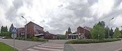
Äänekoski town hall and library | ||
| ||
 Location of Äänekoski in Finland | ||
| Coordinates: 62°36′N 025°43.5′E / 62.600°N 25.7250°ECoordinates: 62°36′N 025°43.5′E / 62.600°N 25.7250°E | ||
| Country | Finland | |
| Region | Central Finland | |
| Sub-region | Äänekoski sub-region | |
| Charter | 1911 | |
| City rights | 1973 | |
| Government | ||
| • Town manager | Matti Tuononen | |
| Area (2011-01-01)[1] | ||
| • Total | 1,138.38 km2 (439.53 sq mi) | |
| • Land | 884.54 km2 (341.52 sq mi) | |
| • Water | 253.84 km2 (98.01 sq mi) | |
| Area rank | 101st largest in Finland | |
| Population (2016-03-31)[2] | ||
| • Total | 19,609 | |
| • Rank | 54th largest in Finland | |
| • Density | 22.17/km2 (57.4/sq mi) | |
| Population by native language[3] | ||
| • Finnish | 98.7% (official) | |
| • Swedish | 0.1% | |
| • Others | 1.2% | |
| Population by age[4] | ||
| • 0 to 14 | 17.4% | |
| • 15 to 64 | 64% | |
| • 65 or older | 18.7% | |
| Time zone | EET (UTC+2) | |
| • Summer (DST) | EEST (UTC+3) | |
| Municipal tax rate[5] | 20.5% | |
| Website | www.aanekoski.fi | |

Äänekoski is an industrial town and municipality of Finland.
Geography
It is located in the province of Western Finland and is part of the Central Finland region. It is neighboured by Kannonkoski, Konnevesi, Laukaa, Saarijärvi, Uurainen, Vesanto and Viitasaari. The town has a population of 19,609 (31 March 2016)[6] and covers an area of 1,138.38 square kilometres (439.53 sq mi) of which 253.84 km2 (98.01 sq mi) is water.[1] There are altogether 170 lakes in Äänekoski. Biggest lakes are Keitele, Kuhnamo and Niinivesi[7] The population density is 22.17 inhabitants per square kilometre (57.4/sq mi).
Consolidation
The municipality of Äänekosken maalaiskunta was consolidated to Äänekoski in 1969 and the municipality of Konginkangas in 1993. The municipalities of Sumiainen and Suolahti were consolidated to Äänekoski in 2007.
Demographics
The municipality is unilingually Finnish.[3]
Disasters
In 2004, the worst road accident ever in Finland occurred in Äänekoski, the Konginkangas bus disaster.
Twin towns – Sister cities
The following cities or municipalities are twinned with Äänekoski:[8]
-
 Örnsköldsvik Municipality, Sweden
 -
 Brande, Brande Municipality, Denmark
 -
 Sigdal, Norway
 -
 Alushta, Alushta municipality Russia
 - Borovichi, Novgorod Oblast, Russia (status unknown)
- Sestroretsk, Russia
Gallery
 Falu red log building in Äänekoski
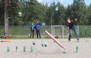 Finnish Skittles game in Äänekoski
 A pulp mill factory in Äänekoski.
 A lake and a bridge near the Äänekoski city centre.
 A porter locomotive of the Äänekoski-Suolahti narrow gauge railway.
 A harbour in Äänekoski.
 A freight train departing from a pulp mill in Äänekoski.
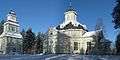 Konginkangas Church.
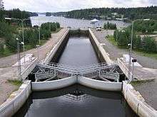 Kapeenkoski Lock of Keitele–Päijänne canal.
 A fisherman catching a small pike on Lake Kiimasjärvi.
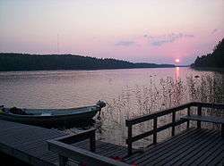 A sunset at the Lake Keitele.
 Sumiainen Church.
 Suolahti Church.
 Hietama Church.
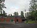 Äänekoski Church.
 Suolahti Harbour.
References
- 1 2 "Area by municipality as of 1 January 2011" (PDF) (in Finnish and Swedish). Land Survey of Finland. Retrieved 9 March 2011.
- ↑ "Ennakkoväkiluku sukupuolen mukaan alueittain, maaliskuu.2016" (in Finnish). Statistics Finland. Retrieved 31 March 2016.
- 1 2 "Population according to language and the number of foreigners and land area km2 by area as of 31 December 2008". Statistics Finland's PX-Web databases. Statistics Finland. Retrieved 29 March 2009.
- ↑ "Population according to age and gender by area as of 31 December 2008". Statistics Finland's PX-Web databases. Statistics Finland. Retrieved 28 April 2009.
- ↑ "List of municipal and parish tax rates in 2011". Tax Administration of Finland. 29 November 2010. Retrieved 13 March 2011.
- ↑ "Population by municipality as of 31 December 2006". Population Information System (in Finnish and Swedish). Population Register Center of Finland. Retrieved 2 May 2010.
- ↑ "Äänekoski". Järviwiki. Finland's Environmental Administration. 2012. Retrieved 27 February 2012.
- ↑ "Äänekosken kaupungin ystävyyskuntatoiminnan edistäminen" (in Norwegian). City of Äänekoski. Retrieved 2012-06-01.
External links
| Wikivoyage has a travel guide for Äänekoski. |
![]() Media related to Äänekoski at Wikimedia Commons
Media related to Äänekoski at Wikimedia Commons
- Town of Äänekoski – Official website, finnish
| Municipalities | ||
|---|---|---|
| Former municipalities |
| |