Roslyn Heights, New York
Roslyn Heights (also known as "The Heights") is both a hamlet and census-designated place (CDP) in Nassau County, New York, United States. It is considered part of the Greater Roslyn area, which is anchored by the Village of Roslyn.[1] The population was 6,577 at the 2010 census.
Roslyn Heights, New York | |
|---|---|
Hamlet and census-designated place | |
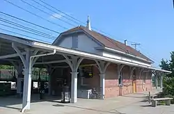 The Roslyn station on the Long Island Rail Road, located within the northern part of Roslyn Heights. | |
| Nickname(s): "The Heights" | |
 Location in Nassau County and the state of New York. | |
 Roslyn Heights, New York Location within the state of New York | |
| Coordinates: 40°46′57″N 73°38′29″W | |
| Country | |
| State | |
| County | |
| Government | |
| • Town Supervisor | Judi Bosworth (D) |
| Area | |
| • Total | 1.5 sq mi (3.9 km2) |
| • Land | 1.5 sq mi (3.9 km2) |
| • Water | 0.0 sq mi (0.0 km2) |
| Elevation | 174 ft (53 m) |
| Population (2010) | |
| • Total | 6,577 |
| Demonym(s) | Roslynian |
| Time zone | UTC-5 (Eastern (EST)) |
| • Summer (DST) | UTC-4 (EDT) |
| ZIP code | 11577 |
| Area code(s) | 516 |
| FIPS code | 36-63814 |
| GNIS feature ID | 0962934 |
Roslyn Heights is in the eastern part of the Town of North Hempstead, at exit 37 on the Long Island Expressway (Interstate 495).[2] The Zip Code for Roslyn Heights is 11577.
Geography
According to the United States Census Bureau, the CDP has a total area of 1.5 square miles (3.9 km2), all of it land.
Education
Although most of Roslyn Heights is served by the Roslyn Union Free School District, portions of the school-aged population are enrolled in the East Williston Union Free school district, the Herricks Union Free School District, as well as the Mineola Union Free School District.

Demographics
At the 2000 census there were 6,295 people, 2,168 households, and 1,773 families in the CDP. The population density was 4,223.6 per square mile (1,631.2/km2). There were 2,226 housing units at an average density of 1,493.5/sq mi (576.8/km2). The racial makeup of the CDP was 79.03% White, 6.45% African American, 0.11% Native American, 10.01% Asian, 2.00% from other races, and 2.40% from two or more races. Hispanic or Latino of any race were 6.45%.[3]
Of the 2,168 households 39.1% had children under the age of 18 living with them, 65.8% were married couples living together, 12.5% had a female householder with no husband present, and 18.2% were non-families. 15.6% of households were one person and 8.9% were one person aged 65 or older. The average household size was 2.89 and the average family size was 3.21.
The age distribution was 26.7% under the age of 18, 5.8% from 18 to 24, 25.8% from 25 to 44, 25.7% from 45 to 64, and 15.9% 65 or older. The median age was 40 years. For every 100 females, there were 93.6 males. For every 100 females age 18 and over, there were 90.6 males.
The median household income was $84,705 and the median family income was $100,474. Males had a median income of $76,812 versus $38,343 for females. The per capita income for the village was $40,132. About 4.5% of families and 5.7% of the population were below the poverty line, including 8.4% of those under age 18 and 2.7% of those age 65 or over.
Transportation
Rail
Roslyn Heights is served by the Oyster Bay Branch of the Long Island Rail Road. Two stations are located either within or on the border of Roslyn Heights:[2]
- Roslyn (located in the heart of the hamlet, just south of Lincoln Avenue)
- Albertson (located on the border between the hamlets of Albertson and Roslyn Heights, just north of I.U. Willets Road)
Bus
Roslyn Heights is served by two Nassau Inter-County Express (NICE) bus routes, as of July, 2020:[4][5]
- The n23 (Mineola-Manorhaven)
- The n27 (Hempstead-Glen Cove)
Highways
Two limited-access highways run through and serve Roslyn Heights:[2]
- The Long Island Expressway (I-495) (exit 37)
- The Northern State Parkway (exits 28, 29, & 30)
Notable people
- Gary Ackerman, former Democratic Congressman for the 5th District of New York State
- Eric Asimov, dining reporter for The New York Times
- Emile Zola Berman, litigator whose defense roster included Sirhan Sirhan
- Anthony Cumia, broadcaster, creator of Compound Media
- Katarzyna Dolinska, America's Next Top Model contestant
- Bernard Madoff, NASDAQ chairman who received 150-year sentence in 2009 for investor fraud
- Chris Miller, author and co-writer, Animal House
- Christopher Morley, children's author and journalist
- Van Toffler, president of MTV
- Fred Wilpon, owner of the New York Mets
- Jeff Wilpon, Chief Operating Officer of the New York Mets
- Richard Zimler, novelist
See also
References
- "Timeline of Roslyn History | Roslyn, NY". www.roslynny.gov. Retrieved 2020-08-10.
- "Roslyn Heights". Google Maps. Retrieved 2020-08-10.
- "U.S. Census website". United States Census Bureau. Retrieved 2008-01-31.
- "Nassau Inter-County Express - Maps and Schedules". www.nicebus.com. Retrieved 2020-08-10.
- "Nassau Inter-County Express Bus Route Map, July, 2020". Nassau Inter-County Express (NICE). Retrieved 2020-08-09.
External links
| Authority control |
|---|