Main Street (Queens)
Main Street is a major north-south street in the borough of Queens in New York City, extending from Queens Boulevard in Briarwood to Northern Boulevard in Flushing. Created in the 17th century as one of Flushing's main roads, Main Street has been lengthened at various points in its existence.
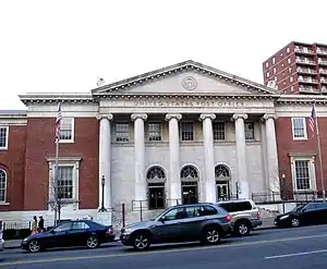 Flushing Main Post Office on Main Street | |
| Owner | City of New York |
|---|---|
| Maintained by | NYCDOT |
| Length | 3.9 mi[1] (6.3 km) |
| Location | Queens, New York City |
| South end | |
| Major junctions | |
| North end | |
Route description
Main Street runs relatively north to south with two to three lanes in either direction, and serves as the major road for Flushing, Queens. From the north, it begins at Northern Boulevard in Downtown Flushing, also known as Flushing Chinatown, one of New York City's largest Asian enclaves.[2][3] Just south of Roosevelt Avenue and the Long Island Rail Road overpass, Kissena Boulevard (formerly Jamaica Road) branches off from Main Street at a triangle, before traveling on a parallel course. After passing through Kissena Park, Main Street intersects with the Long Island Expressway north of Queens College.[4][5][6][7]
South of Queens College, it intersects with Jewel Avenue near the neighborhood of Pomonok.[4][5][6][7] The stretch of Main Street in Kew Gardens Hills south of the Long Island Expressway is home to a large Jewish community, including many Orthodox, Ashkenazi, and Bukharan Jews.[2][8][9] At the south end of Kew Gardens Hills near Jamaica, Main Street intersects with Union Turnpike and the Grand Central Parkway service road. Westbound Union Turnpike feeds into the Kew Gardens Interchange, connecting to the Grand Central, the Van Wyck Expressway, the Jackie Robinson Parkway, and Queens Boulevard.[4][5][6][7] Near its southern end, two entrance ramps branch off from the center of Main Street, feeding into the southbound Van Wyck. The two one-way spurs of Main Street run for three more blocks before ending in Briarwood, at adjacent intersections with Queens Boulevard.[4][5][6][7]
Traffic
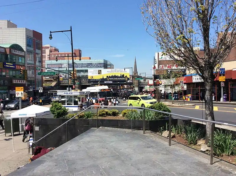

The most congested area of Main Street is at its northern end in Downtown Flushing, between Sanford Avenue and Northern Boulevard. Other congestion points include the intersections with the Long Island Expressway; the Union Turnpike/Grand Central Parkway (GCP) interchange, from 73rd Avenue south to the GCP; and its southern terminus, at Queens Boulevard.[7]
History
_(14779470611).jpg.webp)
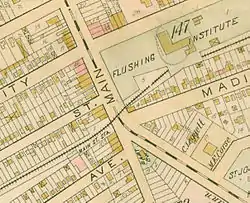
For much of its early history Main Street was a quiet, small-town street. In the beginning, it did not extend south of the Port Washington Branch of the Long Island Rail Road.[10] The intersection of Main Street and Northern Boulevard, built in the 17th century, is one of the oldest modern intersections in the United States.[11] As of 1891, it continued four blocks south to Franklin Avenue, as another street called Jaggar Avenue.[11][12]
The street was extended to Cedar Grove Cemetery in 1920.[11] By 1932, Main Street's south end was Reeves Avenue, at the former Spring Hill Golf Club.[10] In 1938, an extension opened to the Grand Central Parkway.[13] By 1940, the areas around Main Street's northern end, near Flushing, were largely developed. Kew Gardens Hills was built around Main Street after World War II.[10] On November 23, 1954 the extension south to Queens Boulevard and the Van Wyck Expressway was opened.[14]
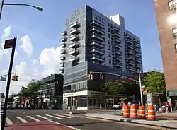
In the 1970s, in the wake of the 1976 fiscal crisis, more real estate became available. The area was quickly settled by Chinese and Koreans.[3] By the late 2000s, the area around Main Street was considered a very diverse community. The New York Times compared it to the classical Main Street and contrasted its character against Wall Street in Manhattan.[2] In the 2020s, Downtown Flushing is undergoing rapid gentrification by Chinese transnational entities.[15]
Transportation
Bus service
The primary public transportation on Main Street is the Q44 bus route, running from the Jamaica Center area through the entire length of Main Street before continuing to the Bronx.[6] In 1999, the Q44 was converted into a limited-stop service, supplemented by Q20A and Q20B local buses running from Jamaica to College Point.[6][16] Prior to 2010, the now-defunct Q74 bus served the southern portion of the street between 73rd and Reeves Avenues. The route, which ran between Kew Gardens – Union Turnpike station and Queens College, was eliminated in 2010 due to budget cuts within the MTA.[17][18][19] The X51 express bus served a portion of the street between Elder Avenue near Kissena Park and Horace Harding Expressway, before being discontinued in the 2010 cuts due to low ridership.[17][20]

The Main Street corridor, along with the parallel Kissena/Parsons Boulevards corridor and the 164th Street corridor, was studied by the NYC Department of Transportation in 2015 for the implementation of Select Bus Service (SBS) between Flushing and Jamaica. This would convert the Q44 route into a bus rapid transit line.[7][21][22][23] As part of the proposal, a bus only lane was proposed for installation on Main Street between Reeves Avenue and Northern Boulevard, as well as on parts of Hillside Avenue and Sutphin Boulevard. After backlash from local businesses, the bus lanes in the Queensboro Hill section of Flushing and in Kew Gardens Hills were dropped from the SBS proposal.[7][21][23][24] However, the Q44 route was approved for SBS conversion in June 2015, and was implemented on November 29, 2015.[21]
Many buses travel through or terminate on the section of Main Street located in Flushing. This includes several routes that run between Flushing and Jamaica, as well as the Q50 bus to Co-op City, Bronx.[4][6][7] Several other buses intersect with the street at other major streets along the route.[6]
Subway and rail
On the New York City Subway, the E, F, and <F> trains of the IND Queens Boulevard Line serve the street at the Briarwood station, where the street intersects with Queens Boulevard and the Van Wyck Expressway.[5][7]
The Downtown Flushing section of the route contains its busiest transit hub, revolving around the Flushing–Main Street terminal for the New York City Subway's 7 and <7> trains at Roosevelt Avenue.[4][25] The Long Island Rail Road serves the area at its elevated station one block south.[4]
Education
Schools
Flushing High School is located a few blocks away from the northern terminus.[4] The Queens College campus, which also houses Townsend Harris High School and John Bowne High School, is located between Reeves Avenue (near the Long Island Expressway) and Melbourne Avenue.[6] Archbishop Molloy High School is located at the southern end of Main Street.[5] An Orthodox Jewish girls' high school, Shevach High School, is located on Main Street between 75 Ave and 75 Rd.[26]
Libraries

Several branches of Queens Library are located on Main Street, including the large Flushing branch at Kissena Boulevard which was rebuilt in the 1990s.[3][4][11] The Kew Gardens Hills branch is near the south end of Main Street.[5]
Points of interest
Notable points of interest include:
- St. George's Church near Roosevelt Avenue[4]
- Flushing Main Post Office, between Sanford and Maple Avenues[4][10]
- Queens Botanical Garden and Kissena Corridor Park between Dahlia and 56th Avenues[4][10]
- NewYork–Presbyterian/Queens (formerly Booth Memorial Hospital and New York Hospital Queens), part of the NewYork–Presbyterian Healthcare System, at Booth Memorial Avenue.[10] Several additional buildings are located farther south.[4]
- Cedar Grove Cemetery, between Reeves Avenue and 68th Drive, north of Jewel Avenue[6]
Other Main Streets in New York City
There are four other Main Streets in the four other boroughs of New York City:
- In Edgewater Park, the Bronx, Main Street is so obscure that it is not notated on street signs. It is a short road in a 675-unit co-op. This Main Street is rarely referred to by its name.[2][11]
- In Dumbo, Brooklyn, Main Street is a two-block cobblestone street that still has old pieces of railroad track embedded into the cobblestones.[2][11][27]
- On Roosevelt Island in Manhattan, Main Street is the sole north-south artery on the island, and is lined mainly with apartment buildings, hospitals, and a small town center consisting of several businesses.[2][11]
- In Tottenville, Staten Island, Main Street is a six-block artery that runs north to south at the western end of the neighborhood.[2][11]
Of the five Main Streets in New York City, Queens's is the busiest and most notable.[2][10][11]
See also
- Flushing Chinatown, also known as Downtown Flushing
References
- Google (July 1, 2018). "Main Street (Queens)" (Map). Google Maps. Google. Retrieved July 1, 2018.
- Wilson, Michael (October 25, 2008). "Familiar and Foreign, It's Main Street, New York City". The New York Times. Retrieved 18 September 2015.
- Morrone, Francis (July 3, 2008). "Flushing, the New Face of the City". nysun.com. The New York Sun. Retrieved 6 July 2015.
- "MTA Neighborhood Maps: neighborhood". mta.info. Metropolitan Transportation Authority. 2018. Retrieved October 1, 2018.
- "MTA Neighborhood Maps: neighborhood". mta.info. Metropolitan Transportation Authority. 2018. Retrieved October 1, 2018.
- "Queens Bus Map" (PDF). MTA New York City Transit.
- "Flushing To Jamaica Select Bus Service: January 22, 2015: Public Open House" (PDF). nyc.gov. Metropolitan Transportation Authority, New York City Department of Transportation. January 22, 2015. Retrieved 6 July 2015.
- Onishi, Norimitsu (January 3, 1997). "Sam Brach Ruled in Kew Gardens Hills. Times Change". nytimes.com. The New York Times. Retrieved 6 July 2015.
- Larson, Hilary (July 13, 2010). "A Jewish Magnet In Central Queens: The increasingly popular Flushing-Kew Gardens area is in the midst of a property crunch". thejewishweek.com. The Jewish Week. Retrieved 6 July 2015.
- Walsh, Kevin (October 2010). "MAIN STREET, Flushing". Forgotten NY. Retrieved 17 September 2014.
- "EXILE ON MAIN STREET, NYC". Forgotten New York. 2010-11-10. Retrieved 2015-10-16.
- Map of Flushing, Queens, dated 1891
- "Main Street Extension Is A 'Hot Potato': With Coming of Fall, Civic Leaders Are Again Demanding Action". Long Island Daily Press. Fultonhistory.com. September 6, 1938. Retrieved 13 January 2016.
- "Queens Thoroughfare Extended" (PDF). The New York Times. November 24, 1954. Retrieved 15 January 2016.
- Sarah Ngu (January 29, 2021). "'Not what it used to be': in New York, Flushing's Asian residents brace against gentrification". The Guardian US. Retrieved August 13, 2020.
The three developers have stressed in public hearings that they are not outsiders to Flushing, which is 69% Asian. 'They’ve been here, they live here, they work here, they’ve invested here,' said Ross Moskowitz, an attorney for the developers at a different public hearing in February...Tangram Tower, a luxury mixed-use development built by F&T. Last year, prices for two-bedroom apartments started at $1.15m...The influx of transnational capital and rise of luxury developments in Flushing has displaced longtime immigrant residents and small business owners, as well as disrupted its cultural and culinary landscape. These changes follow the familiar script of gentrification, but with a change of actors: it is Chinese American developers and wealthy Chinese immigrants who are gentrifying this working-class neighborhood, which is majority Chinese.
- MTA Regional Bus Operations. "Q20A, Q20B, and Q44 bus schedule" (PDF).
- "Queens Bus Map" (PDF). nycityhealth.com. Metropolitan Transportation Authority. Archived from the original (PDF) on 16 September 2015. Retrieved 6 July 2015.
- Sheets, Connor Adams (December 15, 2010). "Seniors slam elimination of Q74". timesledger.com. Times Ledger. Retrieved 5 July 2015.
- "2010 NYC Transit Service Reductions - Revised: Queens Local Bus". mta.info. Metropolitan Transportation Authority. March 19, 2010. Retrieved 6 July 2015.
- "2010 NYC Transit Service Reductions - Revised: Express Bus". mta.info. Metropolitan Transportation Authority. March 19, 2010. Retrieved 6 July 2015.
- "Q44 Select Bus Service" (PDF). New York City Department of Transportation. 9 June 2015. Retrieved 16 October 2015.
- Toure, Madina (January 22, 2015). "NE Queens leaders wary of Select Bus Service proposal". timesledger.com. Times Ledger. Retrieved 6 July 2015.
- Cronin, Jon (June 4, 2015). "DOT Presents Updated SBS Plan For Main St". queenstribune.com. Queen Tribune. Retrieved 6 July 2015.
- Offner, Daniel (April 23, 2015). "No Bus-Only Lane For Part of Main Street". queenstribune.com. Queens Tribune. Retrieved 6 July 2015.
- Sheridan, Dick (April 12, 1999). "MOVING UP ON MAIN ST. ESCALATORS READY AT SUBWAY STATION". Daily News (New York). Retrieved 18 September 2015.
- "Shevach High School". Google.com/maps. Google Maps. Retrieved 2 October 2020.
- Douglass, Harvey (June 26, 1933). "Brooklyn's 'Main Street' Plays Minor Role". Brooklyn Daily Eagle. p. 15. Retrieved 4 July 2016 – via Newspapers.com.
External links
 Media related to Main Street (Queens) at Wikimedia Commons