Buchanan Township, Atchison County, Missouri
Buchanan Township is one of eleven townships in Atchison County, Missouri, United States. As of the 2010 census, its population was 83.[3] The northwest corner of the township is the northwest corner of the entire state.
Buchanan Township | |
|---|---|
 | |
| Coordinates: 40°32′26″N 095°37′16″W | |
| Country | |
| State | |
| County | Atchison |
| Area | |
| • Total | 108.84 km2 (42.02 sq mi) |
| • Land | 106.84 km2 (41.25 sq mi) |
| • Water | 2.00 km2 (0.77 sq mi) 1.84% |
| Elevation | 277 m (909 ft) |
| Population (2010) | |
| • Total | 83 |
| • Density | 0.8/km2 (2/sq mi) |
| FIPS code | 29-09244[2] |
| GNIS feature ID | 0766231 |
Buchanan Township was established in 1858, and named after James Buchanan, the 15th President of the United States.[4]
Geography
Buchanan Township covers an area of and contains no incorporated settlements. Buchanan Township has two cemeteries: Union, and Clayton- Lewis. Greys Lake is within this township.
References
- "US Board on Geographic Names". United States Geological Survey. 2007-10-25. Retrieved 2008-01-31.
- "U.S. Census website". United States Census Bureau. Retrieved 2008-01-31.
- "Geographic Identifiers: 2010 Demographic Profile Data (G001): Buchanan township, Atchison County, Missouri". U.S. Census Bureau, American Factfinder. Archived from the original on February 12, 2020. Retrieved June 25, 2013.
- "Atchison County Place Names, 1928-1945 (archived)". The State Historical Society of Missouri. Archived from the original on 24 June 2016. Retrieved 30 August 2016.CS1 maint: bot: original URL status unknown (link)
External links
Municipalities and communities of Atchison County, Missouri, United States | ||
|---|---|---|
| Cities | 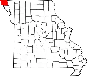 Map of Missouri highlighting Atchison County | |
| Village | ||
| Townships | ||
| CDPs | ||
| Unincorporated communities | ||
| Ghost towns | ||
| ||
This article is issued from Wikipedia. The text is licensed under Creative Commons - Attribution - Sharealike. Additional terms may apply for the media files.