1954 Rainbow Mountain-Fairview Peak-Dixie Valley earthquakes
In 1954, the state of Nevada was struck by a series of earthquakes that began with three M 6.0+ events in July and August that preceded the M 7.3 mainshock and M 6.9 aftershock, both on December 12. All five earthquakes remain some of the largest in the state, and the largest since the Cedar Mountain earthquake (M 7.2) of 1932 and Pleasant Valley event (M 6.8) in 1915. The earthquake was felt throughout much of the western United States.
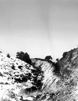 Fault scarp form the December 16 shock near Fairview Peak. Notice the person for scale. | |
 Winnemucca Battle Mountain Lovelock | |
| UTC time | 1954-07-06 11:13:20 |
|---|---|
| 1954-07-06 22:07:41 | |
| 1954-08-24 05:51:32 | |
| 1954-12-16 11:07:11 | |
| 1954-12-16 11:11:34 | |
| 1959-03-23 07:10:26 | |
| ISC event | 890822 |
| 890827 | |
| 890996 | |
| 891356 | |
| 891357 | |
| 881629 | |
| USGS-ANSS | ComCat |
| ComCat | |
| ComCat | |
| ComCat | |
| ComCat | |
| ComCat | |
| Local date | July 6, 1954 to March 23, 1959 |
| Magnitude | 6.8 M |
| 6.2 Mw | |
| 6.6 Mw | |
| 7.3 Mw | |
| 6.9-7.1 Mw | |
| 6.0 Mw | |
| Epicenter | 39.283°N 118.117°W |
| Type | Oblique-slip (Normal) |
| Areas affected | Nevada |
| Total damage | Yes |
| Max. intensity | XII (Extreme) |
| Landslides | Yes |
| Aftershocks | Many |
| Casualties | Some injured |
Geology
The state of Nevada sits within a geologic province known as the Basin and Range. The Basin and Range Province is bounded by the Colorado Plateau, Wasatch Fault, Rio Grande Rift and Trans-Mexican Volcanic Belt. This region in the North American continent is rifting apart in a northwest–southeast direction. Extension of the crust has resulted in a basin and range topography, dominated by dip-slip (normal) faults accommodating extension.[1] Fault block tilting has created many mountain range no more than 16 km wide and 130 km long.[1] In eastern Nevada, along the border with California, faulting mechanism is dominantly strike-slip in a shear zone known as Walker Lane. These faults also causes earthquakes to rattle the state, making Nevada the third most seismically active state in the USA, behind Alaska and California.
Earthquake sequence
Rainbow Mountain earthquakes
The first earthquake that would be followed-up by numerous large shocks occurred on July 6.[2] The event had a magnitude of 6.8 and its focal mechanism was oblique-slip along the Rainbow Mountain Fault. An aftershock of Mw 6.2 came just eleven hours after the M 6.8. It was situated at Salt Wells Marsh, next to the Austin Highway. The shock had a maximum intensity of IX to XII on the Mercalli intensity scale.
Stillwater earthquake
On August 24, an Mw 6.6 earthquake with similar mechanism struck north at the Stillwater National Wildlife Refuge. Surface rupture was measured for 33.1 km.[3] The maximum intensities for this earthquakes was IX (Violent).[4][5] It damaged dams and irrigation facilities around Lovelock.
Fairview earthquake
On December 16, the largest earthquake in the sequence, the Mw 7.3 earthquake was triggered by oblique-slip displacement along the Fairview Peak, West Gate and Gold King Faults for a total length of 64.4 km. Fault scarps of 7 meters in height were seen for 102 meters in the valley.[6] Shaking intensity from this earthquake reached X to XII (Extreme) on the Modified Mercalli Intensity Scale.[7][5] This earthquake was felt for an area of 518,000 square km.[8]
Dixie Valley earthquake
Four minutes and 20 seconds after the Fairview earthquake, an Mw 6.9-7.0 earthquake struck west of Humboldt Salt Marsh along the Dixie Valley Fault Zone.[5] This event ruptured a separate fault for 46.7 km.
Aftershocks
Numerous aftershocks were triggered in the wake of the earthquake including an Mw 6.0 on March 23, 1959.
| Mag | UTC | Ref |
|---|---|---|
| 6.8 | 1954-07-06 11:13:20 | |
| 5.5 | 1954-07-06 11:18:04 | [9] |
| 5.7 | 1954-07-06 11:49:00 | [10] |
| 5.2 | 1954-07-06 13:15:11 | [11] |
| 6.2 | 1954-07-06 22:07:41 | |
| 5.3 | 1954-07-08 19:31:57 | [12] |
| 5.1 | 1954-07-30 02:00:10 | [13] |
| 5.4 | 1954-08-02 10:18:53 | [14] |
| 6.6 | 1954-08-24 05:51:32 | |
| 5.2 | 1954-08-24 05:57:46 | [15] |
| 5.8 | 1954-08-31 22:20:32 | [16] |
| 5.5 | 1954-09-01 05:18:46 | [17] |
| 7.3 | 1954-12-16 11:07:11 | |
| 6.9 | 1954-12-16 11:11:34 | |
| 5.0 | 1954-12-16 11:50:36 | [18] |
| 5.0 | 1954-12-16 11:57:30 | [19] |
| 5.0 | 1954-12-16 13:15:03 | [20] |
| 5.8 | 1954-12-16 14:16:57 | [21] |
| 5.3 | 1954-12-16 14:24:10 | [22] |
| 5.1 | 1954-12-16 15:09:42 | [23] |
| 5.0 | 1954-12-17 20:27:06 | [24] |
| 5.0 | 1954-12-20 17:36:47 | [25] |
| 5.1 | 1956-07-26 09:53:17 | [26] |
| 6.0 | 1959-03-23 07:10:26 |
Aftermath
Numerous fault scarps and offset stream channels were reported as a result of surface ruptures.[27]
The July 6 earthquake caused some destruction in the town of Fallon. Old and poorly built, un-reinforced brick structures were severely damaged, and many chimneys fell as a result. Twelve sailors were injured at the Naval Auxiliary Air Station when shaking knocked heavy steel lockers and shattered glass onto them, the most serious injury was a broken leg.[28] At Lone Tree and Stillwater District, some limited was reported. Canals and drainage systems of the Newlands Reclamation Project near Fallon were damaged heavily due to liquefaction from dam failure.[3] Many culverts were damaged or had collapsed. Highways in the Fallon-Stillwater areas cracked and buckled in some places. A road dropped nearly a meter for more than 300 meters.[29] President Eisenhower declared the region a disaster area and made available $200,000 of disaster relief funding.[3]
The August earthquake caused further destruction to Fallon; seven more structures had to be torn down due to the severity of the damage. More windows, water pipelines and chimneys were broken. The earthquake also totally wrecked repair works done after the July shock.[3]
The December 16 main shocks frightened the residents of Fallon, many of them did not stay in their homes during the winter night. In Reno, the earthquake was felt strongly by many. Plasters fell from the Nevada State Capitol Building in Carson.[30] Fissures up to 30 inches wide opened in highways and the landscape.[31] The earthquakes also triggered rockfalls and deposited large boulders onto highways. US-50 experienced some buckling and cracks, and some roads dropped more than 1.5 meters due to surface faulting.[8]
In Sacramento, 322 km away, the earthquake caused some $20,000 in damages to a water tank belonging to the city's filtration plant.[8]
Fault scarps can still be visited in the affected area.
References
- Price, Jon (2004). "Geology of Nevada" (PDF) – via University of Nevada, Reno.
- "Significant Earthquake Information NEVADA: FALLON". NOAA NCEI. Retrieved November 22, 2020.
- "Nevada's Earthquake History" (PDF). shakeout.org. Retrieved November 22, 2020.
- "Significant Earthquake Information NEVADA: STILLWATER RANGE". NOAA NCEI. Retrieved November 22, 2020.
- Kathleen M. Hodgkinson Ross S. Stein Geoffrey C. P. King (1996). "The 1954 Rainbow Mountain‐Fairview Peak‐Dixie Valley earthquakes: A triggered normal faulting sequence". Journal of Geophysical Research: Atmospheres. 101 (B11): 25459–25471. Bibcode:1996JGR...10125459H. doi:10.1029/96JB01302 – via AGU.
- dePolo, Craig. "An Introduction to Nevada's Earthquake Hazards".
- "Significant Earthquake Information NEVADA: DIXIE VALLEY". NOAA NCEI. Retrieved November 22, 2020.
- Moreno, Rich (April 19, 2019). "All shook up in Fairview Valley". Nevada Appeal. Retrieved November 22, 2020.
- "M 5.5 - Nevada". USGS. Retrieved November 22, 2020.
- "M 5.7 - Nevada". USGS.
- "M 5.2 - Nevada". USGS.
- "M 5.3 - Nevada". USGS.
- "M 5.1 - Nevada". USGS.
- "M 5.4 - Nevada". USGS.
- "M 5.2 - Nevada". USGS.
- "M 5.8 - Nevada". USGS.
- "M 5.5 - Nevada". USGS.
- "M 5.0 - Nevada". USGS.
- "M 5.0 - Nevada". USGS.
- "M 5.0 - Nevada". USGS.
- "M 5.8 - Nevada". USGS.
- "M 5.3 - Nevada". USGS.
- "M 5.1 - Nevada". USGS.
- "M 5.0 - Nevada". USGS.
- "M 5.0 - Nevada". USGS.
- "M 5.1 - Nevada". USGS.
- S. John Caskey, John W. Bell, Alan R. Ramelli, and Steven G. Wesnousky (2004). "Historic Surface Faulting and Paleoseismicity in the Area of the 1954 Rainbow Mountain–Stillwater Earthquake Sequence, Central Nevada". Bulletin of the Seismological Society of America. 94 (4): 1255–1275. Bibcode:2004BuSSA..94.1255C. doi:10.1785/012003012.CS1 maint: multiple names: authors list (link)
- "Nevada earthquakes evoke memories of past quakes". Reno Gazette Journal. December 23, 2015. Retrieved November 22, 2020.
- "Fallon-Stillwater Earthquake – Nevada – July 6, 1954". Devastating Disasters. Retrieved November 22, 2020.
- "Earthquakes in Dixie Valley". Online Nevada. Retrieved November 22, 2020.
- Schwab, Brianna (April 10, 2019). "1954 Earthquake". Churchill County Museum and Archives. Retrieved November 22, 2020.