Trimble Township, Athens County, Ohio
| Trimble Township, Athens County, Ohio | |
|---|---|
| Township | |
|
Palos Covered Bridge | |
 Location of Trimble Township in Athens County | |
| Coordinates: 39°29′50″N 82°5′15″W / 39.49722°N 82.08750°WCoordinates: 39°29′50″N 82°5′15″W / 39.49722°N 82.08750°W | |
| Country | United States |
| State | Ohio |
| County | Athens |
| Area | |
| • Total | 37.5 sq mi (97.0 km2) |
| • Land | 37.1 sq mi (96.0 km2) |
| • Water | 0.4 sq mi (1.0 km2) |
| Elevation[1] | 679 ft (207 m) |
| Population (2010) | |
| • Total | 4,480 |
| • Density | 121/sq mi (46.7/km2) |
| Time zone | Eastern (EST) (UTC-5) |
| • Summer (DST) | EDT (UTC-4) |
| ZIP code | 45782 |
| Area code(s) | 740 |
| FIPS code | 39-77420[2] |
| GNIS feature ID | 1085758[1] |

Trimble Township is one of the fourteen townships of Athens County, Ohio, United States. The 2010 census found 4,480 people in the township,[3] 1,818 of whom lived in the unincorporated portions of the township.
Geography
Located in the far northern part of the county, it borders the following townships:
- Monroe Township, Perry County - north
- Homer Township, Morgan County - east
- Ames Township - southeast corner
- Dover Township - south
- York Township - southwest corner
- Ward Township, Hocking County - west
- Coal Township, Perry County - northwest corner
The farthest north township in Athens County, it is the only county township to border Perry County.
Three villages are located in eastern Trimble Township: Glouster in the north, Trimble in the centre, and Jacksonville in the south.
Name and history
Trimble Township was organized in 1827.[4] Named for Allen Trimble, Governor of Ohio,[5] it is the only Trimble Township statewide.[6]
Government
The township is governed by a three-member board of trustees, who are elected in November of odd-numbered years to a four-year term beginning on the following January 1. Two are elected in the year after the presidential election and one is elected in the year before it. There is also an elected township fiscal officer,[7] who serves a four-year term beginning on April 1 of the year after the election, which is held in November of the year before the presidential election. Vacancies in the fiscal officership or on the board of trustees are filled by the remaining trustees.
References
- 1 2 "US Board on Geographic Names". United States Geological Survey. 2007-10-25. Retrieved 2008-01-31.
- ↑ "American FactFinder". United States Census Bureau. Retrieved 2008-01-31.
- ↑ "Geographic Identifiers: 2010 Demographic Profile Data (G001): Trimble township, Athens County, Ohio". U.S. Census Bureau, American Factfinder. Retrieved July 10, 2013.
- ↑ Walker, Charles Manning (1869). History of Athens County, Ohio, And, Incidentally, of the Ohio Land Company and the First Settlement of the State at Marietta. Robert Clarke & Company. p. 519.
- ↑ Kilbourn, John (1833). "The Ohio Gazetteer, or, a Topographical Dictionary". Scott and Wright. p. 443. Retrieved 12 December 2013.
- ↑ "Detailed map of Ohio" (PDF). United States Census Bureau. 2000. Retrieved 2007-02-16.
- ↑ §503.24, §505.01, and §507.01 of the Ohio Revised Code. Accessed 4/30/2009.
External links
Municipalities and communities of Athens County, Ohio, United States | ||
|---|---|---|
| Cities | 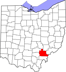 | |
| Villages | ||
| Townships | ||
| CDPs | ||
| Unincorporated communities | ||
| Footnotes | ‡This populated place also has portions in an adjacent county or counties | |