Shock, West Virginia
| Shock, West Virginia | |
|---|---|
| Unincorporated community | |
 Shock, West Virginia  Shock, West Virginia | |
| Coordinates: 38°46′42″N 80°57′59″W / 38.77833°N 80.96639°WCoordinates: 38°46′42″N 80°57′59″W / 38.77833°N 80.96639°W | |
| Country | United States |
| State | West Virginia |
| County | Gilmer |
| Elevation | 741 ft (226 m) |
| Time zone | Eastern (EST) (UTC-5) |
| • Summer (DST) | EDT (UTC-4) |
| ZIP code | 26638 |
| Area code(s) | 304 & 681 |
| GNIS feature ID | 1549928[1] |
Shock is an unincorporated community in Gilmer County, West Virginia, United States. Shock is 13 miles (21 km) southwest of Glenville, along the Right Fork Steer Creek.[2] Shock has a post office with ZIP code 26638.[3]
The community was named after the Shock family, original owners of the town site.[4]
Climate
The climate in this area is characterized by hot, humid summers and generally mild to cool winters. According to the Köppen Climate Classification system, Shock has a humid subtropical climate, abbreviated "Cfa" on climate maps.[5]
References
- ↑ "US Board on Geographic Names". United States Geological Survey. 2007-10-25. Retrieved 2008-01-31.
- ↑ West Virginia Atlas & Gazetteer. Yarmouth, Me.: DeLorme. 1997. p. 44. ISBN 0-89933-246-3.
- ↑ ZIP Code Lookup
- ↑ Kenny, Hamill (1945). West Virginia Place Names: Their Origin and Meaning, Including the Nomenclature of the Streams and Mountains. Piedmont, WV: The Place Name Press. p. 575.
- ↑ Climate Summary for Shock, West Virginia
Municipalities and communities of Gilmer County, West Virginia, United States | ||
|---|---|---|
| Towns | 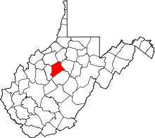 | |
| Unincorporated communities | ||
| Footnotes | ‡This populated place also has portions in an adjacent county or counties | |
This article is issued from Wikipedia - version of the 7/28/2016. The text is available under the Creative Commons Attribution/Share Alike but additional terms may apply for the media files.