Olex, Oregon
| Olex, Oregon | |
|---|---|
| Unincorporated community | |
 Olex, Oregon  Olex, Oregon | |
| Coordinates: 45°29′49″N 120°10′08″W / 45.49694°N 120.16889°WCoordinates: 45°29′49″N 120°10′08″W / 45.49694°N 120.16889°W | |
| Country | United States |
| State | Oregon |
| County | Gilliam |
| Elevation | 1,020 ft (310 m) |
| Time zone | Pacific (PST) (UTC-8) |
| • Summer (DST) | PDT (UTC-7) |
| GNIS feature ID | 1126141[1] |
| Coordinates and elevation from the Geographic Names Information System (GNIS)[1] | |
Olex is an unincorporated community in Gilliam County, Oregon, United States, at an elevation of 1,020 feet (310 m).[1] It is along Oregon State Route 19 about halfway between Condon and Arlington, at the bottom of the Rock Creek Grade.
Olex was named for Alex Smith, a local resident; the name was misspelled in transmission. The Olex post office operated from 1874 to 1976.[2] Olex is the birthplace of Oregon politician Earl Snell.[3]
References
- 1 2 3 "Olex". Geographic Names Information System. United States Geological Survey. November 28, 1980. Retrieved October 26, 2016.
- ↑ McArthur, Lewis A.; McArthur, Lewis L. (2003) [1928]. Oregon Geographic Names (7th ed.). Portland, Oregon: Oregon Historical Society Press. p. 721. ISBN 978-0875952772.
- ↑ "Governor Earl W. Snell's Administration: Biographical Note". Oregon State Archives. Retrieved January 30, 2015.
External links
- Photo of the Olex Elementary School by PGHolbrook
Municipalities and communities of Gilliam County, Oregon, United States | ||
|---|---|---|
| Cities | 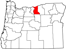 | |
| Unincorporated communities | ||
| Former communities | ||
This article is issued from Wikipedia - version of the 10/26/2016. The text is available under the Creative Commons Attribution/Share Alike but additional terms may apply for the media files.