Exeter, Pennsylvania
| Exeter, Pennsylvania | |
|---|---|
| Borough | |
|
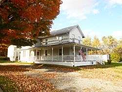
House on Slocum Avenue | |
 Exeter | |
| Coordinates: 41°19′32″N 75°49′10″W / 41.32556°N 75.81944°WCoordinates: 41°19′32″N 75°49′10″W / 41.32556°N 75.81944°W | |
| Country | United States |
| State | Pennsylvania |
| County | Luzerne |
| Region | Greater Pittston |
| Incorporated | 1884 |
| Government | |
| • Type | Borough Council |
| Area | |
| • Total | 5.0 sq mi (12.9 km2) |
| • Land | 4.7 sq mi (12.1 km2) |
| • Water | 0.3 sq mi (0.8 km2) |
| Population (2010) | |
| • Total | 5,652 |
| • Density | 1,100/sq mi (440/km2) |
| Time zone | Eastern (EST) (UTC-5) |
| • Summer (DST) | EDT (UTC-4) |
| Area code(s) | 570 |
Exeter is a borough in the Greater Pittston-Wilkes-Barre area of the center-west Wyoming Valley region in Luzerne County, Pennsylvania, United States, about 10 miles (16 km) west of Scranton and a few miles northwest of Wilkes-Barre on the opposite shore of the main Susquehanna River fork.
The borough was founded in the middle of a fertile agricultural area—once the heartlands of the Susquehannock Amerindian peoples—and much lumbering and coal-mining was carried out in the area from early in the 19th century. In the 1830s the region entered a boom period and began shipping coal by the Pennsylvania Canal, and by the 1840s even down the Lehigh Canal to Allentown, Philadelphia, Trenton, Wilmington, New York City, and other East Coast cities and ports via the connecting engineering works of the Lehigh Coal & Navigation Company such as the upper Lehigh Canal, the Ashley Planes and the early Lehigh and Susquehanna Railroad, along with other railroads that flocked to or were born in the area. After severe flooding ripped up the upper Lehigh Canal in the 1860s, the L&S was extended to the Delaware along the lower canal, keeping the big cities' markets connected to the still growing Wyoming Valley collieries and breakers. A second rail line was pushed up the Lehigh Gorge, the Lehigh Valley Railroad enabling a resurgent coal exportation to the East Coast cities and connecting the region to the Erie Railroad and Buffalo, New York. By 1900, the population consisted of 1,948 persons; in 1910, 3,537 persons; and in 1940, 5,802 persons. The town lost usable lands in 1959 in the Knox Mine Disaster, when the river broke into the roof of sub-river anthracite mines and, in one moment, all but killed the local anthracite mining industry. Subsequently, despite the local loss of industry, the fact that the population was 5,652 at the 2010 census[1] indicates that the former Indian and farmlands have been attractive to building developers.
Geography

Exeter is located along the right and west bank of the main branch Susquehanna River at 41°19′32″N 75°49′10″W / 41.32556°N 75.81944°W (41.325530, -75.819353),[2] and hosts the important Wyoming Valley connecting highway U.S. Route 11 siting between West Pittston and West Wyoming athwart the highway. The majority of its streets are arrayed to either side of the highway, as is true of most of the neighboring communities, there are many secondary streets that parallel both the highway and so the river bank and rising uplands away from the Wyoming Valley basin floor and flat bottomlands.
According to the United States Census Bureau, the borough has a total area of 5.0 square miles (12.9 km2), of which 4.7 square miles (12.1 km2) is land and 0.31 square miles (0.8 km2), or 6.52%, is water.[3] It lies on the west side of the Susquehanna River and has two distinct islands: Wintermoot and Scovell. It also has a number of smaller islands, some of which were 'grown' by efforts to dump rock and soil to plug up the mine roof breakthroughs, as had been done, for example, in many tunnel projects under the Thames in London, and other Victorian river tunnels. The Army Corp of Engineers, however, concluded corking a tunnel with one level floor limit and a host of interconnected mine shafts and galleries at many different levels were two very different problems only superficially related.
Its zip code is 18643, shared with West Pittston.
History
The name Exeter derives from the ancient city of Exeter in Devon, England. Numerous other places have also been given the name Exeter.
Poet Anthony Petrosky was born in Exeter.
Wyoming Massacre took place in present-day Exeter. See Wikipedia article on Wyoming, Pennsylvania.
Government
Mayor Cassandra Coleman was appointed to office in 2008 amid much contention. She was a 21-year-old political science student at King's College in Wilkes-Barre. She was recommended for the position to council by her grandfather, Mayor Joseph F. Coyne III, before his death.
Exeter Borough resides within the Wyoming Area School District. Wyoming Area Catholic School is a parochial school within the borough.
Demographics
| Historical population | |||
|---|---|---|---|
| Census | Pop. | %± | |
| 1890 | 790 | — | |
| 1900 | 1,948 | 146.6% | |
| 1910 | 3,537 | 81.6% | |
| 1920 | 4,176 | 18.1% | |
| 1930 | 5,724 | 37.1% | |
| 1940 | 5,802 | 1.4% | |
| 1950 | 5,130 | −11.6% | |
| 1960 | 4,747 | −7.5% | |
| 1970 | 4,670 | −1.6% | |
| 1980 | 5,493 | 17.6% | |
| 1990 | 5,691 | 3.6% | |
| 2000 | 5,955 | 4.6% | |
| 2010 | 5,652 | −5.1% | |
| Est. 2015 | 5,596 | [4] | −1.0% |
| Sources:[5][6][7] | |||
As of the census[6] of 2000, there were 5,955 people, 2,482 households, and 1,640 families residing in the borough. The population density was 1,278.4 people per square mile (493.4/km2). There were 2,641 housing units at an average density of 567.0 per square mile (218.8/km2). The racial makeup of the borough was 98.69% White, 0.49% African American, 0.13% Native American, 0.13% Asian, 0.03% from other races, and 0.52% from two or more races. Hispanic or Latino of any race were 0.57% of the population.
There were 2,482 households, out of which 26.0% had children under the age of 18 living with them, 48.8% were married couples living together, 13.1% had a female householder with no husband present, and 33.9% were non-families. 30.1% of all households were made up of individuals, and 14.7% had someone living alone who was 65 years of age or older. The average household size was 2.35 and the average family size was 2.92.
In the borough the population was spread out, with 21.0% under the age of 18, 6.9% from 18 to 24, 27.9% from 25 to 44, 23.4% from 45 to 64, and 20.9% who were 65 years of age or older. The median age was 41 years. For every 100 females there were 84.0 males. For every 100 females age 18 and over, there were 80.3 males.
The median income for a household in the borough was $31,681, and the median income for a family was $40,050. Males had a median income of $31,569 versus $21,693 for females. The per capita income for the borough was $16,022. About 7.6% of families and 8.5% of the population were below the poverty line, including 11.1% of those under age 18 and 5.8% of those age 65 or over.
References
- ↑ "Profile of General Population and Housing Characteristics: 2010 Demographic Profile Data (DP-1): Exeter borough, Pennsylvania". U.S. Census Bureau, American Factfinder. Retrieved April 12, 2012.
- ↑ "US Gazetteer files: 2010, 2000, and 1990". United States Census Bureau. 2011-02-12. Retrieved 2011-04-23.
- ↑ "Geographic Identifiers: 2010 Demographic Profile Data (G001): Exeter borough, Pennsylvania". U.S. Census Bureau, American Factfinder. Retrieved April 12, 2012.
- ↑ "Annual Estimates of the Resident Population for Incorporated Places: April 1, 2010 to July 1, 2015". Retrieved July 2, 2016.
- ↑ "Census of Population and Housing". U.S. Census Bureau. Retrieved 11 December 2013.
- 1 2 "American FactFinder". United States Census Bureau. Retrieved 2008-01-31.
- ↑ "Incorporated Places and Minor Civil Divisions Datasets: Subcounty Resident Population Estimates: April 1, 2010 to July 1, 2012". Population Estimates. U.S. Census Bureau. Retrieved 11 December 2013.
Municipalities and communities of Luzerne County, Pennsylvania, United States | ||
|---|---|---|
| Cities | 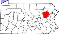 | |
| Boroughs |
| |
| Townships | ||
| CDPs | ||
| Unincorporated communities |
| |
| Footnotes | ‡This populated place also has portions in an adjacent county or counties | |